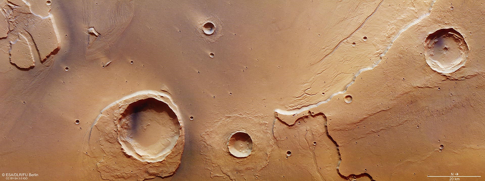
This image focuses on the mouth of Kasei Valles, as it transitions into Chryse Planitia. The region experienced extreme flooding billions of years ago, which has left its mark in this scene. The region was imaged by the High Resolution Stereo Camera on ESA’s Mars Express on May 25, 2016, during orbit 15714. The image is centered on 309ºE/27ºN and the ground resolution is about 15 m per pixel. It was created using data from the nadir channel, the field of view which is aligned perpendicular to the surface of Mars, and the camera’s color channels. North is to the right. Credit: ESA/DLR/FU Berlin, CC BY-SA 3.0 IGO
European Space Agency’s Mars Express has captured images of one of the largest outflow channel networks on Mars.
The Kasei Valles channel system extends around 3,000 km(1,900 mi) from its source region in Echus Chasma – which lies east of the bulging volcanic region Tharsis and just north of the Valles Marineris canyon system – to its sink in the vast plains of Chryse Planitia.

This context image shows a region of Mars where Kasei Vallis empties into the vast Chryse Planitia. The region outlined by the large white box indicates the area imaged during Mars Express orbit 15714, with the smaller inner box highlighted in an associated image release. In this context image, north is up. Credit: NASA MGS MOLA Science Team
A combination of volcanism, tectonics, collapse, and subsidence in the Tharsis region led to several massive groundwater releases from Echus Chasma, which subsequently flooded the Kasei Valles region around 3.6–3.4 billion years ago. These ancient mega-floods have left their mark on the features seen today.
Sections of Kasei Valles have already been imaged by Mars Express during its 14 years at the Red Planet, but this new image, taken on May 25, 2016, captures a portion right at its mouth.
A 25 km-wide (16 mi-wide) impact crater – Worcester Crater – just left to the center of the main color image, has done its best to stand up to the erosive forces of the mega-floods.
While much of the blanket of material surrounding the crater – which was originally thrown out from inside the crater during the impact – has been eroded, the section downstream of the flood has survived. Over time this has led to the overall appearance of a streamlined island, with its stepped topography downstream perhaps suggesting variations in water levels or different flood episodes.
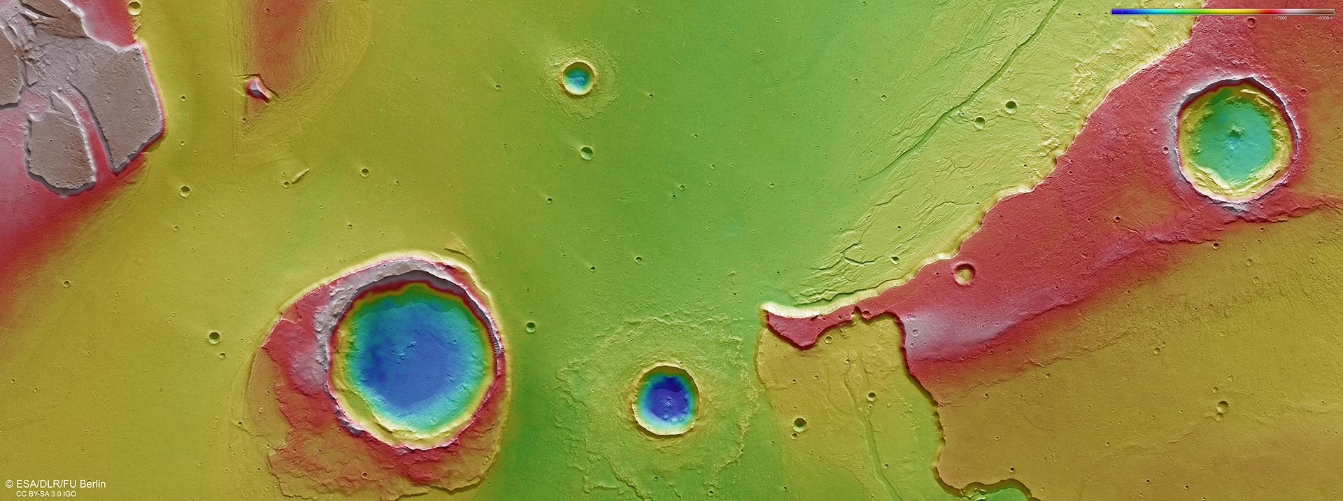
The color-coded topographic view shows relative heights and depths of terrain in the region of Mars where Kasei Vallis reaches Chryse Planitia. As indicated in the key at top right, whites and reds represent the highest terrain, while blue is the lowest. The image is based on a digital terrain model of the region, from which the topography of the landscape can be derived. This region was imaged by the High Resolution Stereo Camera on ESA’s Mars Express on 25 May 2016 during orbit 15714. The image is centered on 309ºE/27ºN and the ground resolution is about 15 m per pixel. North is to the right. Credit: ESA/DLR/FU Berlin, CC BY-SA 3.0 IGO
By contrast, the debris blanket surrounding the adjacent crater has remained intact. This suggests the impact producing that crater occurred after the major flooding.
Moreover, the appearance of the debris blanket tells a story on the nature of the subsurface: in this case it points to the floodplain being rich in water or water-ice.
Indeed, the pattern is reminiscent of a ‘splash’: the debris ejected from the crater was rich in water, allowing it to flow more easily. As it slowed, the debris behind it piled up, pushing up the material at its periphery into ramparts.
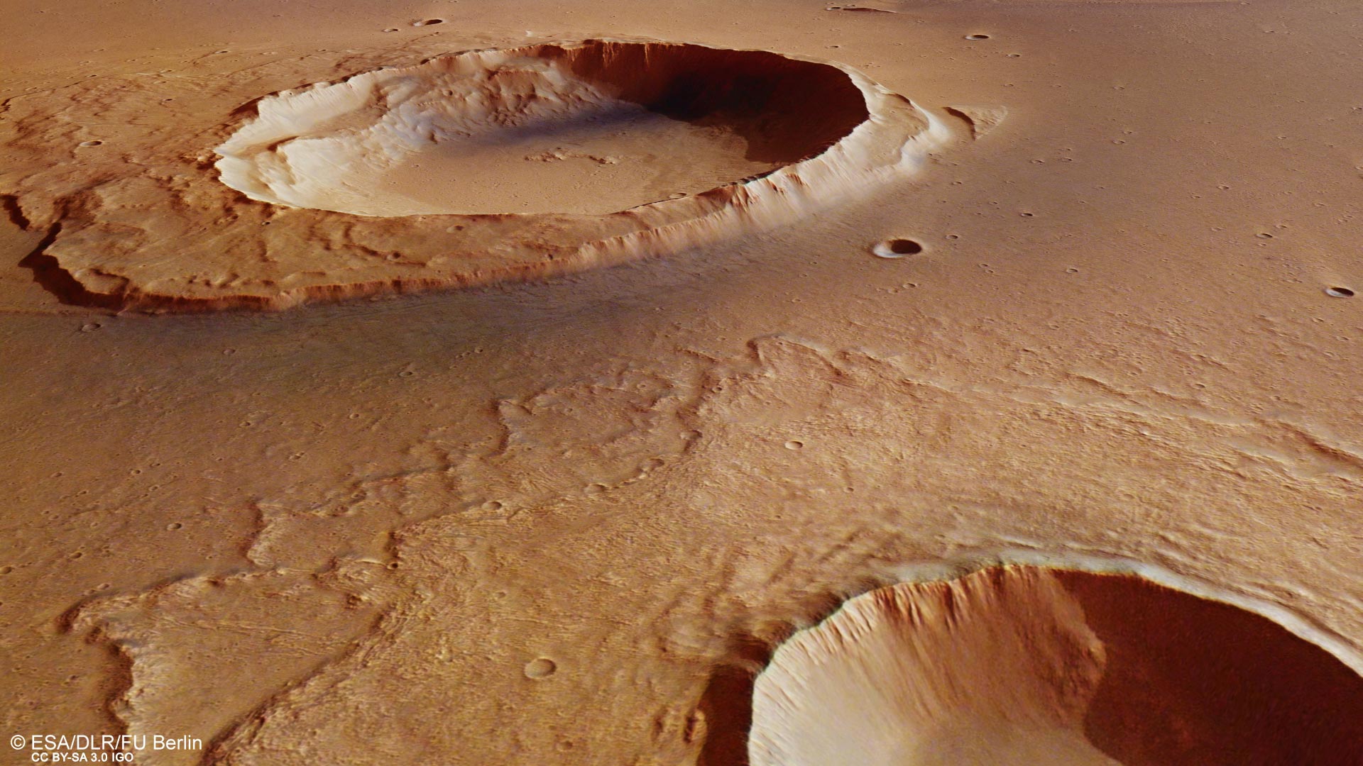
This perspective view looks from an unnamed crater at bottom right towards a 25 km-wide crater named Worcester Crater. The region sits at the mouth of Kasei Valles, where fierce floodwaters emptied into Chryse Planitia.
The image was generated using data from the high-resolution stereo camera on ESA’s Mars Express. This scene is part of the region imaged on May 25, 2016, during orbit 15714. The main image is centered on 309ºE/27ºN and the ground resolution is about 15 m per pixel. The view is looking approximately to the south. Credit: ESA/DLR/FU Berlin, CC BY-SA 3.0 IGO
The perspective view shows a close-up of this rampart feature and looks from the associated crater towards the eroded Worcester crater in the background.
The large crater at the northernmost part (right, top) of the main image does not appear to have penetrated as deep as Worcester crater and its neighbor. Indeed, it is located on a plateau at least 1 km (0.6 mi) higher than the plains below.
Nonetheless, there is a small depression in the center of the crater, which usually implies a weaker layer – such as ice – was buried underneath at the time of the impact.
Close inspection also reveals the faint outline of the crater’s ejecta blanket, including a portion that spilled over onto the plains below.
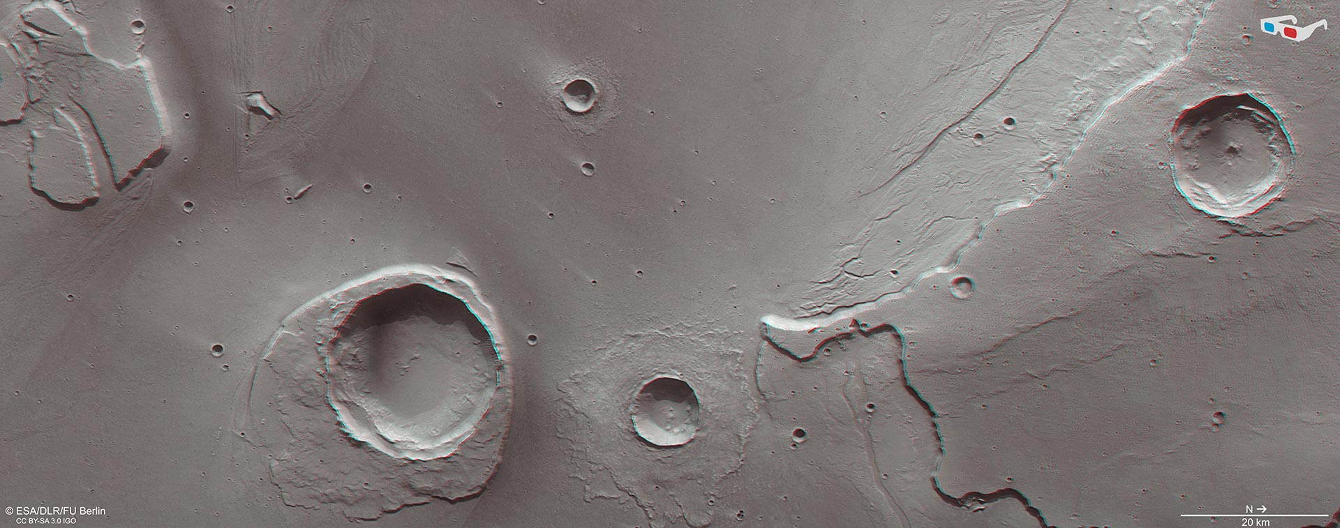
This anaglyph view, showing a portion of terrain at the mouth of Kasei Vallis, provides a 3D view of the landscape when viewed using red–green or red–blue glasses. The image is based on data acquired by the nadir channel and one stereo channel of the High Resolution Stereo Camera on Mars Express on May 25, 2016 during orbit 15714. The image is centered on 309ºE/27ºN and the ground resolution is about 15 m per pixel. North is to the right. Credit: ESA/DLR/FU Berlin, CC BY-SA 3.0 IGO
The ejecta shows an interesting grooved pattern that the other craters in this view seem to be lacking. This suggests a difference in the nature of the impact itself, perhaps either with the energy imparted during the impact, the way in which the ejecta was emplaced from the crater, or in the composition of the plateau material.
Small dendritic channels can be seen all around the plateau, which perhaps hint at the varying flood magnitudes during numerous episodes of flooding.
A number of smaller craters in the flat plains can also be found. These appear to have lighter-colored ‘tails’ pointing in the opposite direction to the flow of water coming from Kasei Valles.
These craters were formed by impacts that took place after the catastrophic flooding, their delicate tails created by winds blowing in a westwards direction ‘up’ valley. Their raised rims influence wind flow over the crater such that the dust immediately ‘behind’ the crater remains undisturbed in comparison to the surrounding, more exposed, plains.
This scene therefore preserves a record of geological activity spanning billions of years of the Red Planet’s history.


Be the first to comment on "ESA’s Mars Express View Remnants of Mega-Flood on Mars"