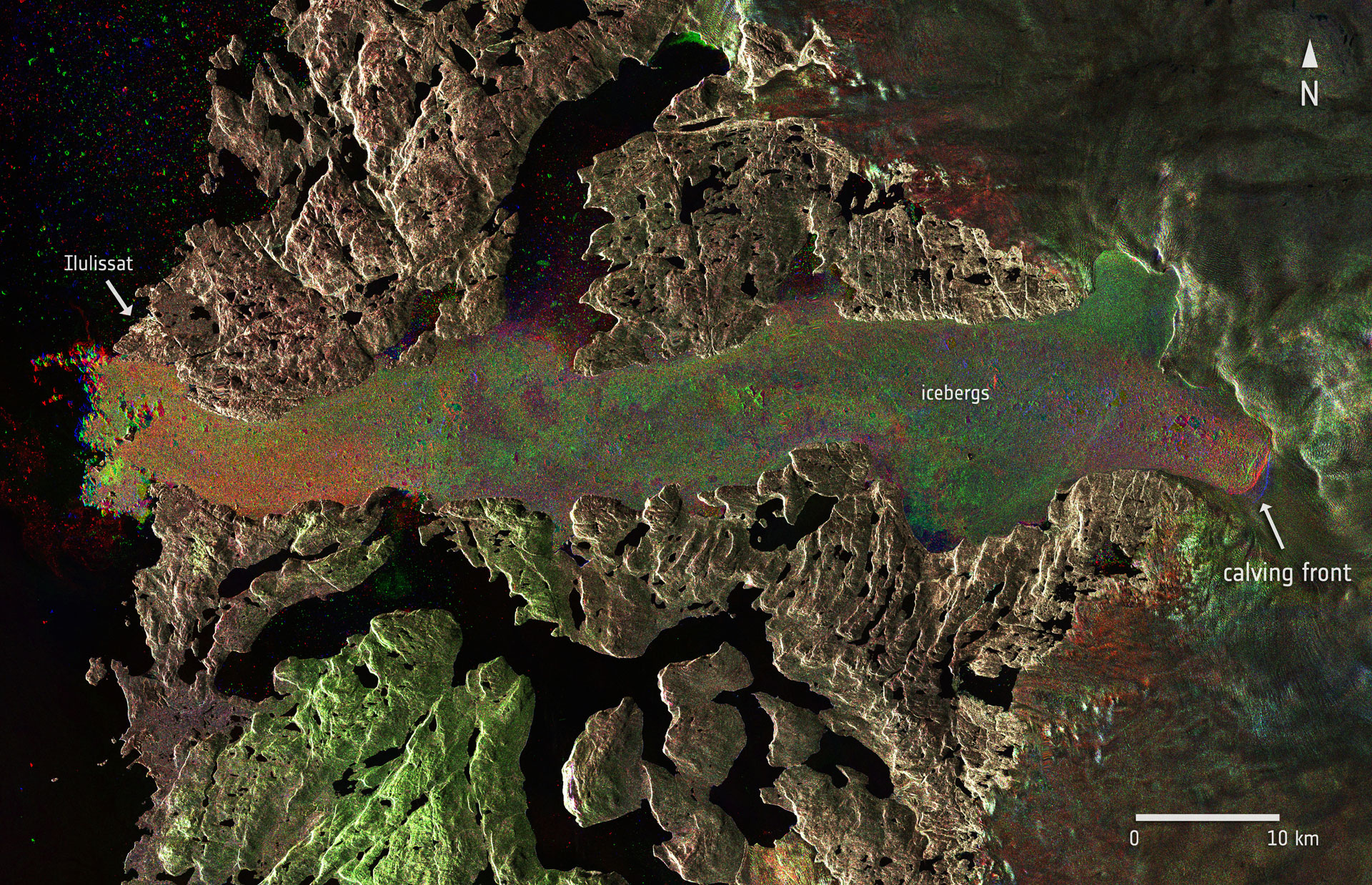
Radar images from Sentinel-1A captured the Jakobshavn glacier in western Greenland before and after a massive calving event, which took place between 14 and 16 August 2015. The image composite includes different Sentinel-1A images from 27 July, and 13 and 19 August. The red, green, and blue indicate the position of the calving front and other dynamic features on each respective date.
New ESA satellite images show that the fastest-moving glacier in the world (the Jakobshavn glacier) shed a massive chunk of ice measuring around 12.5 square kilometers – one of the most significant calving events on record.
Radar images from Sentinel-1A captured the Jakobshavn glacier in western Greenland before and after the event, which took place between 14 and 16 August.
Comparing images taken on 27 July, and 13 and 19 August, the new face of the glacier has been pushed inland by several kilometers to what appears to be its furthest easterly location since monitoring began in the mid-1880s.
The image time series suggests that between 27 July and 13 August, the glacier advanced westward before the calving caused the rapid retreat of the ice front to its position on 19 August.
It is estimated that the glacier lost a total area of 12.5 square kilometers (4.8 square miles). Assuming the ice is about 1,400m (4,600ft)deep, this equates to a volume of 17.5 cubic kilometers (4 cubic miles) – which could cover the whole of Manhattan Island with a layer of ice about 300m (1,000ft) thick.

This optical image of Jakobshavn glacier in western Greenland, acquired by Sentinel-2A on 16 August 2015, offers a valuable perspective of the scale of the calving event that took place between 14 and 16 August. The contour indicates the area of ice lost between images acquired on 6 and 16 August. All-weather radar images from the Sentinel-1A satellite provide a year-round view of glacier dynamics.
The history of this last calving event is also revealed in images taken by Sentinel-2A on 6 and 16 August.
Jakobshavn glacier drains 6.5% of the Greenland ice sheet, producing around 10% of its icebergs. This amounts to some 35 billion tonnes of ice that calve every year.
Other similar events have been documented where the glacier parted with 7 square kilometers (2.7 square miles) of ice, both earlier this year and back in 2010.
Icebergs are often so large that they cannot float away easily. They remain, sometimes for years, stuck on the bottom in shallower areas of the fjord until they finally melt enough to disperse, break into pieces, or are pushed out by icebergs coming up from behind.
Studied for over 250 years, the Jakobshavn glacier has helped to develop our understanding of the importance of ice streams and glaciers in climate change, icecap glaciology, and how they affect sea level.
Sentinel-1A and Sentinel-2A are the first two satellites in orbit for Europe’s Copernicus program. While Sentinel-1A is an all-weather, day-and-night radar imaging mission, Sentinel-2A carries a multispectral imager.
Since radar can ‘see’ through clouds and in the dark, Sentinel-1A is particularly useful for maritime surveillance, ship safety, sea-ice charting, and ice-sheet monitoring. Sentinel-2A also demonstrates here that it is also valuable for ice and climate monitoring.
Together, these and future Sentinels, in particular the upcoming Sentinel-3 mission, will add further complementary measurements for operational applications and scientific purposes.


Be the first to comment on "Jakobshavn Glacier Sheds a Massive Chunk of Ice"