
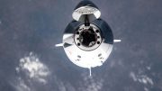
The Gulfstream IV-SP is a high altitude, high speed, twin turbofan jet aircraft acquired by NOAA in 1996. Credit: NOAA
Acquired in 1996 and typically used for studying hurricanes, the Gulfstream IV-SP (G-IV) operated by NOAA will have a new mission for the next two months. This highly specialized NOAA jet will be gathering data as it travels over the North Pacific Ocean to help meteorologists better predict winter storms over the North American continent.
A highly specialized NOAA jet typically used to study hurricanes will fly over the North Pacific Ocean during the next two months gathering data that will enhance winter storm forecasts for the entire North American continent.
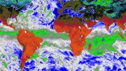
From its temporary base at U.S. Coast Guard Air Station Barbers Point in Honolulu, NOAA’s high-altitude, twin-engine Gulfstream IV-SP aircraft will deploy special sensors to collect information where the jet stream and moisture from the ocean interact and breed potentially powerful winter storms that impact North America several days later.
Data on wind speed and direction, pressure, temperature, and humidity from the sensors will be monitored and quality checked by meteorologists aboard the aircraft. NOAA then will use the information to predict the location and intensity of high winds, destructive surf conditions, severe weather, and flooding rainfall caused by winter storms.
“These atmospheric observations, combined with satellite and other data, have proven to significantly enhance four-to-seven-day winter weather forecasts,” said Captain Barry Choy, chief science officer for the National Centers for Environmental Prediction (NCEP), part of NOAA’s National Weather Service. “Improved forecasts mean longer warning lead times for the public, emergency managers, air carriers, utility companies, and others to prepare for significant winter storms, protect lives and property, and minimize economic impacts.”
The mission will take the Gulfstream IV north, east, and west of Hawaii, and occasionally as far as Alaska. Data gathered in the upper atmosphere by the NOAA aircraft, which flies at 45,000 feet, will be supplemented by data collected at lower altitudes by a U.S. Air Force Reserve weather reconnaissance plane. The flight tracks for both aircraft will be developed by NCEP.
“Together, these flights will help forecasters paint a detailed three-dimensional picture of weather systems over Pacific regions where more accurate information is needed for computer weather forecast models,” said Jack R. Parrish, flight director, and meteorologist with NOAA’s Office of Marine and Aviation Operations.
Based at the NOAA Aircraft Operations Center, located at MacDill Air Force Base in Tampa, Fla., the Gulfstream IV is part of the NOAA fleet of aircraft and ships operated, managed, and maintained by the NOAA Office of Marine and Aviation Operations.


Be the first to comment on "NOAA Gulfstream IV-SP Aircraft to Boost North American Weather Forecasting"