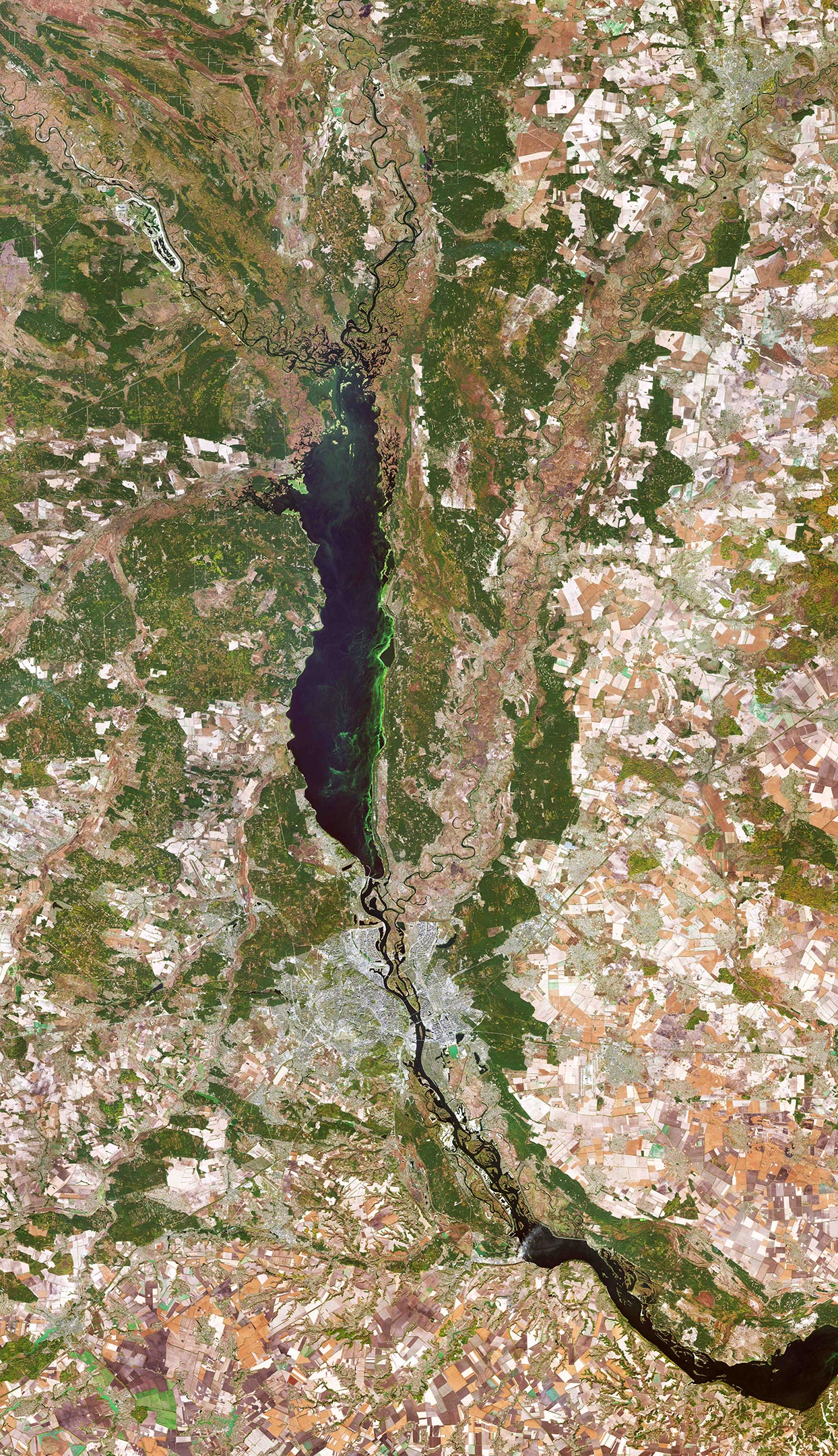
Kyiv, also spelled Kiev, is visible just below the center of this Copernicus Sentinel-2 satellite image, along the Dnieper River in north-central Ukraine. The city covers a total area of around 840 sq km (324 sq miles) and is home to approximately three million people. (Cropped: Click image for full view.) Credit: Contains modified Copernicus Sentinel data (2019), processed by ESA, CC BY-SA 3.0 IGO
This satellite image from the Copernicus Sentinel-2 mission takes us over Kyiv – the capital and most populous city of Ukraine. (Note that this image was captured in 2019, well before Russia’s invasion of Ukraine, which began on February 24, 2022.)
Kyiv, also spelled Kiev, is visible just below the center of the image, along the Dnieper River in north-central Ukraine. The city covers a total area of around 840 square km (324 square miles) and is home to approximately three million people.
Originally just on the west bank, today the city of Kyiv spans across both sides of the Dnieper River, which flows southwards through the city. The Dnieper is the fourth-longest river in Europe, after the Volga, Danube, and Ural rivers. It rises on the southern slopes of the Valdai Hills of Russia and flows in a southerly direction through western Russia, Belarus, and Ukraine to the Black Sea.
Directly above the city of Kyiv is the Kyiv Reservoir – a large water reservoir that is 110 km (68 miles) in length and 12 km (7 miles) in width. The reservoir is mainly used for irrigation, hydroelectricity generation, and industrial and public consumption.
The neon green colors in the Kyiv Reservoir indicate a high quantity of algae. Algal blooms are dense layers of microscopic plants that occur on the surface of lakes, or other bodies of water, when there is an overabundance of nutrients on which algae depend. These high levels of nutrients are often caused by human pollution, such as wastewater or fertilizer runoff from agriculture.
Owing to Ukraine’s climate and arable land, agriculture plays a large role in the country’s economy. Large, agricultural plots dominate this week’s image, with corn, wheat, and barley being the country’s main crops. With over 40 million hectares of agricultural land covering 70% of the country, agriculture is Ukraine’s largest export industry.
Copernicus Sentinel-2 is a two-satellite mission. Each satellite carries a high-resolution camera that images Earth’s surface in 13 spectral bands. The mission is mostly used to track changes in the way land is being used and to monitor the health of our vegetation.
This image is also featured on the Earth From Space video program, which is embedded above.

Be the first to comment on "Exploring Earth From Space: Kyiv, Ukraine"