
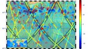
Credit: Contains modified Copernicus Sentinel data (2020-21), processed by ESA, CC BY-SA 3.0 IGO
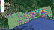
The Copernicus Sentinel-2 mission takes us over northwest Lesotho – a small, land-locked country surrounded entirely by South Africa.
Known for its tall mountains and narrow valleys, Lesotho is the only nation in the world that lies completely above 1000 m in elevation. Lesotho has an area of just 30,000 sq km (12,000 sq miles), around the same size as Belgium, and has a population of around two million.
Around 80% of the country’s population lives in rural areas and more than three-quarters of these people are engaged in agriculture – mostly traditional, rainfed cereal production and extensive animal grazing. The country’s agricultural system faces a growing number of issues, including a small portion of the land deemed arable, as well as other climate-related vulnerabilities such as drought, floods, and extreme temperatures occurring more frequently.
This composite image was created by combining three separate images from the near-infrared channel from the Copernicus Sentinel-2 mission over a period of nine months.
The first image, captured on November 27, 2020, is assigned to the red channel and represents the onset of the wet summer season; the second from March 12, 2021, represents green, and was captured towards the end of the wet season; and the third from August 19, 2021, covers the blue part of the spectrum, captured during the short, dry season.
All other colors visible in the image are different mixtures of red, green, and blue, and vary according to the stage of vegetation growth. A distinct pattern emerges due to topographical differences in this mountainous landscape, such as altitude and slope, which influence local water availability.
Maseru, the capital and largest urban center of Lesotho, lies directly on the Lesotho— South Africa border. The city is located on the left bank of the Caledon River, also known as the Mohokare River, visible in black.
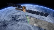
The Copernicus Sentinel-2 mission is designed to provide images that can be used to distinguish between different crop types as well as data on numerous plant indices, such as leaf area, leaf chlorophyll, and leaf water. The mission’s revisit time of just five days, along with the mission’s range of spectral bands, mean that changes in plant health and growth can be more easily monitored.
Be the first to comment on "Exploring Earth From Space: Lesotho – Small Country Surrounded Entirely by South Africa"