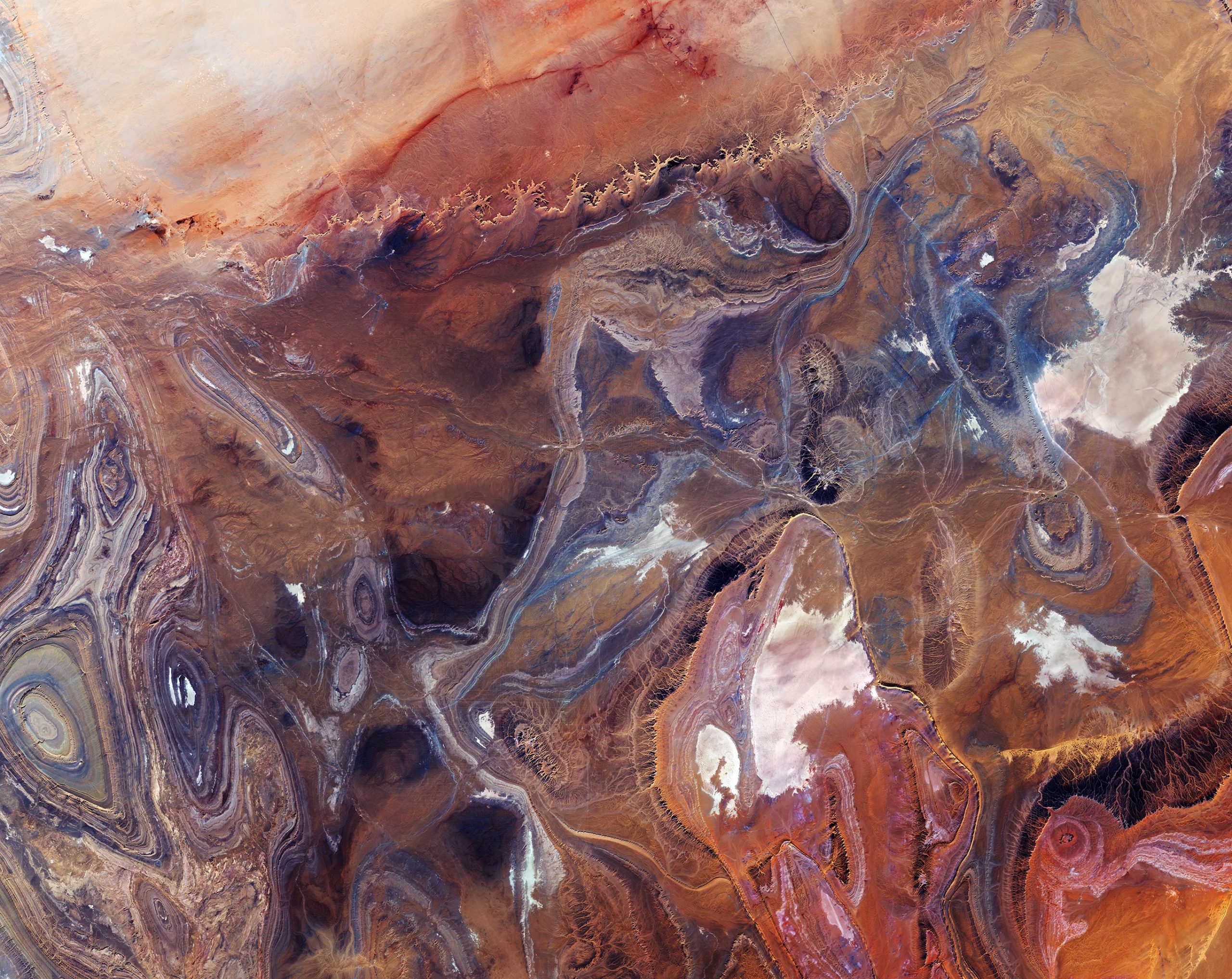
This image, also featured on the Earth from Space video program, was captured on January 12, 2020 by the Copernicus Sentinel-2 mission – a two-satellite mission to supply the coverage and data delivery needed for Europe’s Copernicus program. Credit: Contains modified Copernicus Sentinel data (2020), processed by ESA, CC BY-SA 3.0 IGO
The Copernicus Sentinel-2 mission takes us over the Tanezrouft Basin – one of the most desolate parts of the Sahara Desert.
Zoom in to see this image at its full 10 m (33 ft) resolution or click on the circles to learn more about the features in this image.
Tanezrouft is a region of the Sahara lying in southern Algeria and northern Mali. The hyperarid area is known for its soaring temperatures and scarce access to water and vegetation, a reason why it’s often referred to as the ‘Land of Terror’. There are no permanent residents that live here, only occasional Tuareg nomads.
The barren plain extends to the west of the Hoggar mountains and southeast of the sandy Erg Chech. The terrain shows evidence of water erosion that occurred many years ago, when the Sahara Desert’s climate was much wetter, as well as wind erosion caused by frequent sandstorms – exposing ancient folds in the Paleozoic rocks.
The region is characterized by dark sandstone hills, steep canyon walls, salt flats (visible in white in the image), stone plateaus, and seas of multi-story sand dunes known as ‘ergs’. Concentric rings of exposed sandstone strata create a stunning pattern predominantly visible in the left of the image.
White lines in the right of the image are roads that lead to In Salah – the capital of the In Salah Province and In Salah District. Just above the center-left of the image, an airstrip can be seen. An interesting, grid-like pattern can be seen in the bottom of the image and mostly consists of human-made clearings and roads.
This image was captured on January 12, 2020, by the Copernicus Sentinel-2 mission – a two-satellite mission to supply the coverage and data delivery needed for Europe’s Copernicus program.


The “interesting feature” — a grid-like pattern — at 2:15 in the movie cannot be seen in the GoogleEarth Landsat imagery. Inasmuch as the lines go across the topography without deviation, I suspect it is not a man-made ground feature, but instead, some sort of electronic noise or processing artifact!