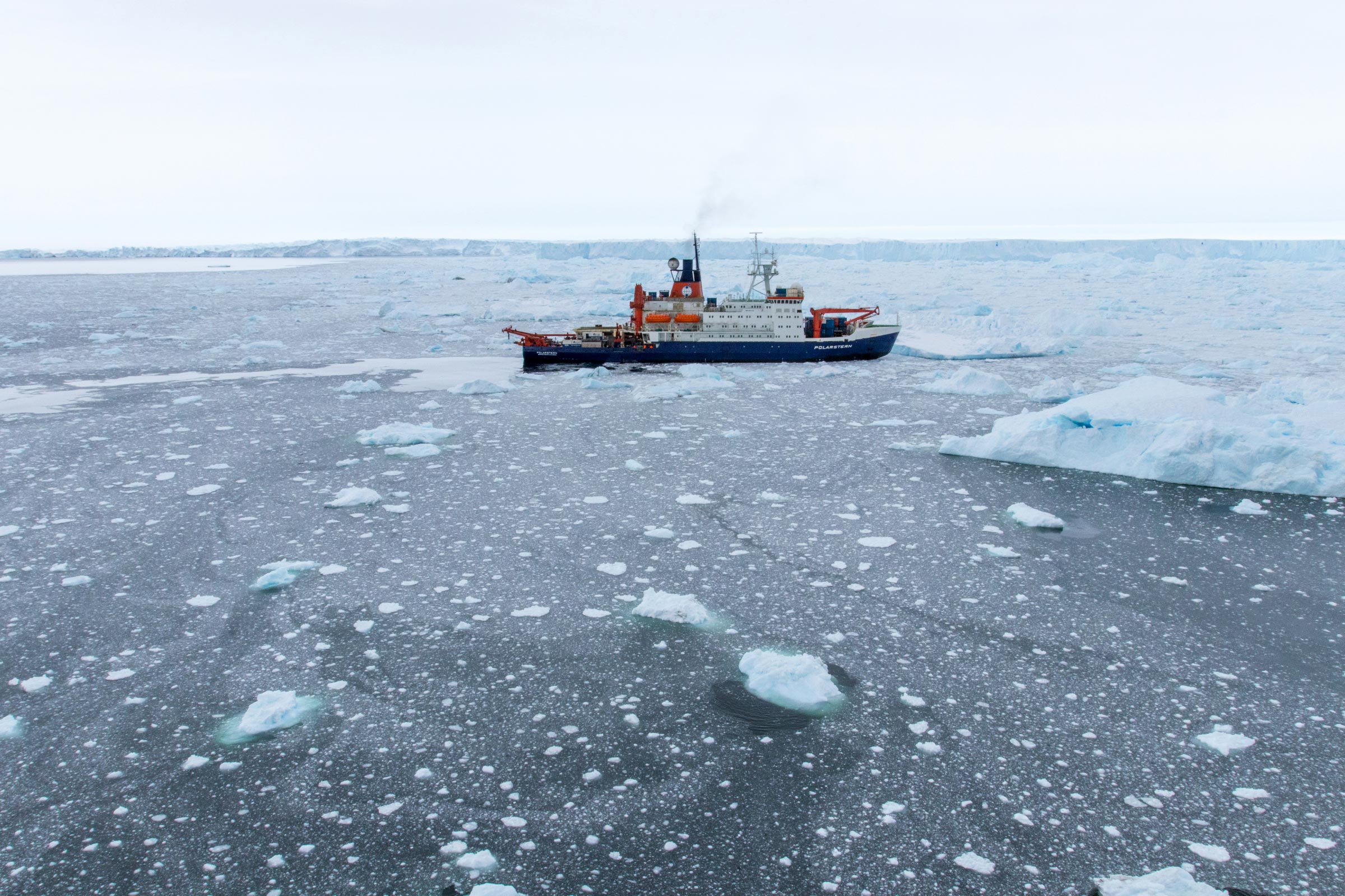
Germany’s icebreaking research vessel Polarstern (operated by the Alfred Wegener Institute Helmholtz Centre for Polar and Marine Research). Credit: Alfred-Wegener-Institut / Thomas Ronge
AWI experts confirm the delayed spread of the ice sheet 35 million years ago.
Roughly 35 million years ago, Earth cooled rapidly. At roughly the same time, the Drake Passage formed between South America and the Antarctic, paving the way for the Antarctic Circumpolar Current. Thanks to these two factors, Antarctica was soon completely covered in ice. As a study from the Alfred Wegener Institute now shows, this massive glaciation was delayed in at least one region. This new piece of the puzzle concerning the early history of the West Antarctic Ice Sheet could help to predict its unstable future. The study was just released in the Nature journal Communications Earth & Environment.
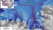
The West Antarctic has long been a focal point for climatologists. Here, the nearby Amundsen Sea is reachable by the West Antarctic Ice Sheet that covers the continent. The ice still makes direct contact with the ground close to the shore, but when it gets closer to open water, it floats. The ice shelf is being more and more eroded from below as a result of the saltwater becoming steadily warmer due to climate change. The grounding line, the last location where the ice is still on the ground, advances farther inland. The Thwaites Glacier, which empties into the Amundsen Sea, is losing twice as much ice as it did thirty years ago due to meltwater and iceberg calving. Global sea levels would increase by more than three meters if the West Antarctic Ice Sheet completely disintegrated.
“The stability of the West Antarctic Ice Sheet is critical to the future development of the global sea level,” says the study’s first author, Gabriele Uenzelmann-Neben from the Alfred Wegener Institute, Helmholtz Centre for Polar and Marine Research (AWI). “Accordingly, researchers around the world are working to predict the future behavior of the ice in a warmer world using numerical simulation. The more we know about the history of the West Antarctic Ice Sheet, the more accurate we can make these models. Its more recent history is well-documented, but we still know very little about its earlier years – particularly the formation phase. Our study delivers an important piece of the puzzle.”
In the course of two research cruises onboard the Polarstern, the Geophysicist and her team investigated sediments in the vicinity of Pine Island Trough, a channel-like furrow in the seafloor of the shallow part of the Amundsen Sea that stretches from north to south and leads directly toward the western coast of Antarctica. To collect data, the AWI team relied on the tried and proven reflection seismology method: the Polarstern towed a 3,000-meter-long measuring cable – or streamer – behind her. The streamer is equipped with hydrophones that utilize a total of 240 measuring channels. During survey cruises, an airgun is used to produce seismic pulses behind the ship. These pulses penetrate the seafloor and are reflected back at geological boundaries – e.g. between the sediment and hard rock – which is recorded by the streamer’s hydrophones. Based on the different travel times for the waves and the respective positions of the individual channels, the internal structure of the seafloor can be mapped.
The measurement data revealed a large sediment body, a sediment drift, on the eastern flank of Pine Island Trough, one with no counterpart on its western side. “Because of the Coriolis effect produced by Earth’s rotation, this asymmetrical deposition of a sediment drift on the trough’s eastern side but not the western one can only have been produced by a deep-water current that flowed toward the coast from north to south,” says Uenzelmann-Neben. “In order for that to occur, the ocean circulation at the time of the deposition had to be similar to today’s conditions, that is, the prevailing westerlies and the Antarctic Circumpolar Current had to have been located far to the south. And similar to today, the deep water upwelled through the trough must have been comparatively warm.”
Additional study of pollen from sediment cores gathered near the trough indicate that the base of the sediment drift was formed roughly 34 to 36 million years ago. At precisely the same time – the Eocene-Oligocene boundary – temperatures plummeted around the globe, and the Antarctic continent became covered in ice. “Our study offers compelling evidence that at the time of the great glaciation, warmer deep water upwelled near the Amundsen Sea shelf and delayed the West Antarctic Ice Sheet’s expansion to the sea,” the AWI Geophysicist explains. “This important and unexpected finding emphasizes the tremendous importance that ocean currents had even during the formation phase of the West Antarctic Ice Sheet and continue to have today. Armed with this additional knowledge concerning the ice sheet’s earliest phase, forecasts on its future stability and ice retreat can now be improved.”
Reference: “Deep water inflow slowed offshore expansion of the West Antarctic Ice Sheet at the Eocene-Oligocene transition” by Gabriele Uenzelmann-Neben, Karsten Gohl, Katharina Hochmuth, Ulrich Salzmann, Robert D. Larter, Claus-Dieter Hillenbrand, Johann P. Klages and Science Team of Expedition PS104, 21 February 2022, Communications Earth & Environment.
DOI: 10.1038/s43247-022-00369-x


“At precisely the same time – the Eocene-Oligocene boundary – temperatures plummeted around the globe, and the Antarctic continent became covered in ice.”
The Oligocene was a period of extensive effusive vulcanism. In California’s Sierra Nevada, deep ash buried the Eocene landscape, ultimately resulting in what is today called a “reversed topography.” It shouldn’t be a great surprise that the world cooled with widespread, long-lasting volcanic activity that threw ash and sulfate aerosols into the atmosphere. Modern civilization and our moderate climate are a result of low rates of vulcanism.
The Oligocene was a period of extensive effusive vulcanism. In California’s Sierra Nevada, deep ash buried the Eocene landscape, ultimately resulting in what is today called a “reversed topography.” It shouldn’t be a great surprise that the world cooled with widespread, long-lasting volcanic activity that threw ash and sulfate aerosols into the atmosphere. Modern civilization and our moderate climate are a result of low rates of vulcanism.
No mention of the many active volcanoes under the west Antarctic ice sheet. Gee could that be another cause of ice melt?
The Eemian Period, during the last interglacial (such as we’re in now) was 1-2°C warmer at lower elevations and 5-6°C warmer at higher elevations with sea levels 6 meters higher than they are now. You would think the “experts” would all know this and prepare accordingly but they would rather point fingers than educate everyone that the West Antarctic ice sheet may have collapsed at that time (and there wasn’t anyone to blame for carbon emissions). Maybe we are doomed to repeat our history since we don’t know it very well.
Give or take a few million years! Very accurate.