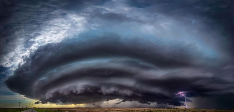
Supercell Storm
The most devastating tornadoes are often preceded by a cloudy plume of ice and water vapor billowing above a severe thunderstorm. New research reveals the mechanism for these plumes could be tied to “hydraulic jumps” – a phenomenon Leonardo Da Vinci observed more than 500 years ago.
When a cloudy plume of ice and water vapor billows up above the top of a severe thunderstorm, there’s a good chance a violent tornado, high winds or hailstones bigger than golf balls will soon pelt the Earth below.
A new Stanford University-led study, published on September 10, 2021, in Science, reveals the physical mechanism for these plumes, which form above most of the world’s most damaging tornadoes.
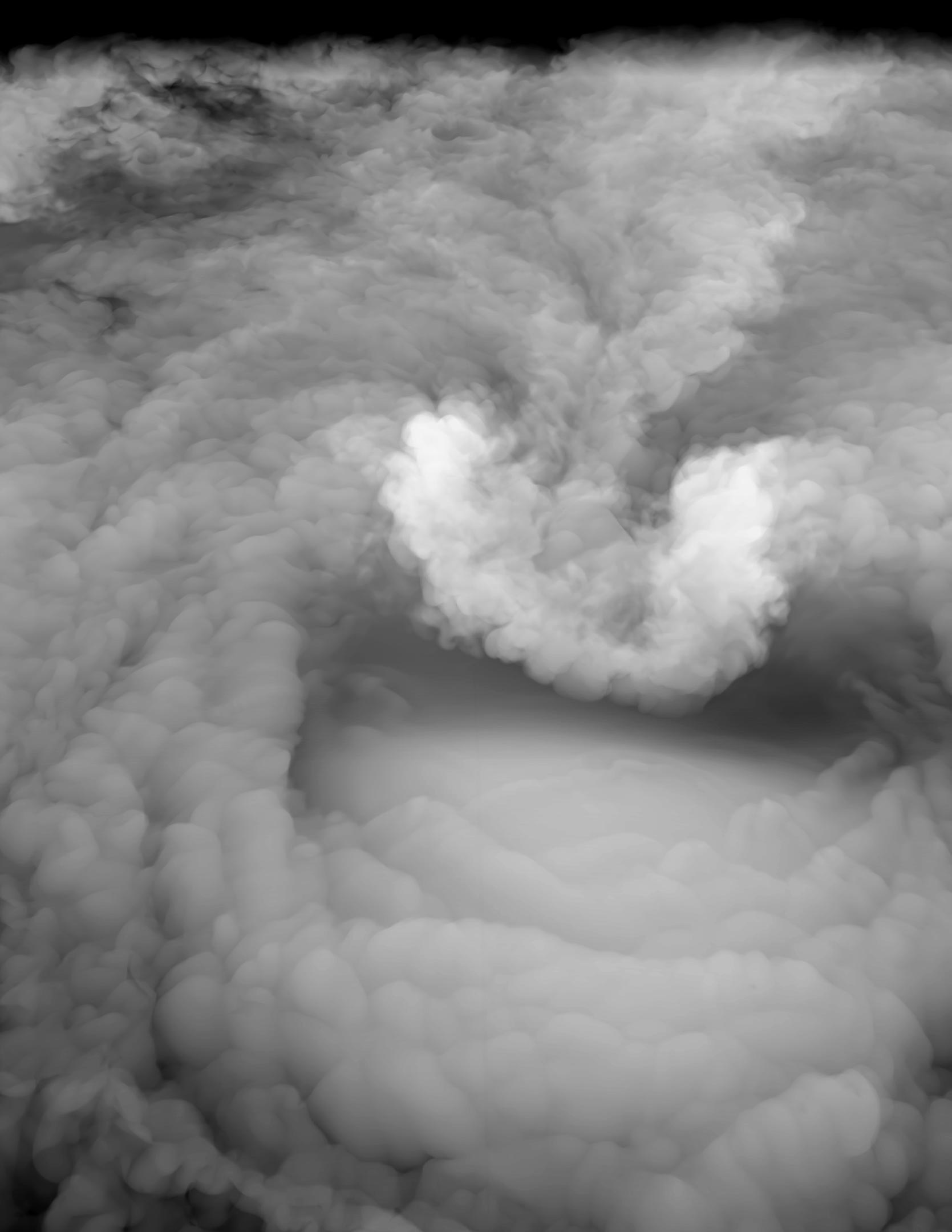
A 3D rendering of the simulation experiment that produces the AACP in the sheltered side or lee of the overshooting top. Credit: Leigh Off, David Semeraro
Previous research has shown they’re easy to spot in satellite imagery, often 30 minutes or more before severe weather reaches the ground. “The question is, why is this plume associated with the worst conditions, and how does it exist in the first place? That’s the gap that we are starting to fill,” said atmospheric scientist Morgan O’Neill, lead author of the new study.
The research comes just over a week after supercell thunderstorms and tornadoes spun up among the remnants of Hurricane Ida as they barreled into the U.S. Northeast, compounding devastation wrought across the region by record-breaking rainfall and flash floods.
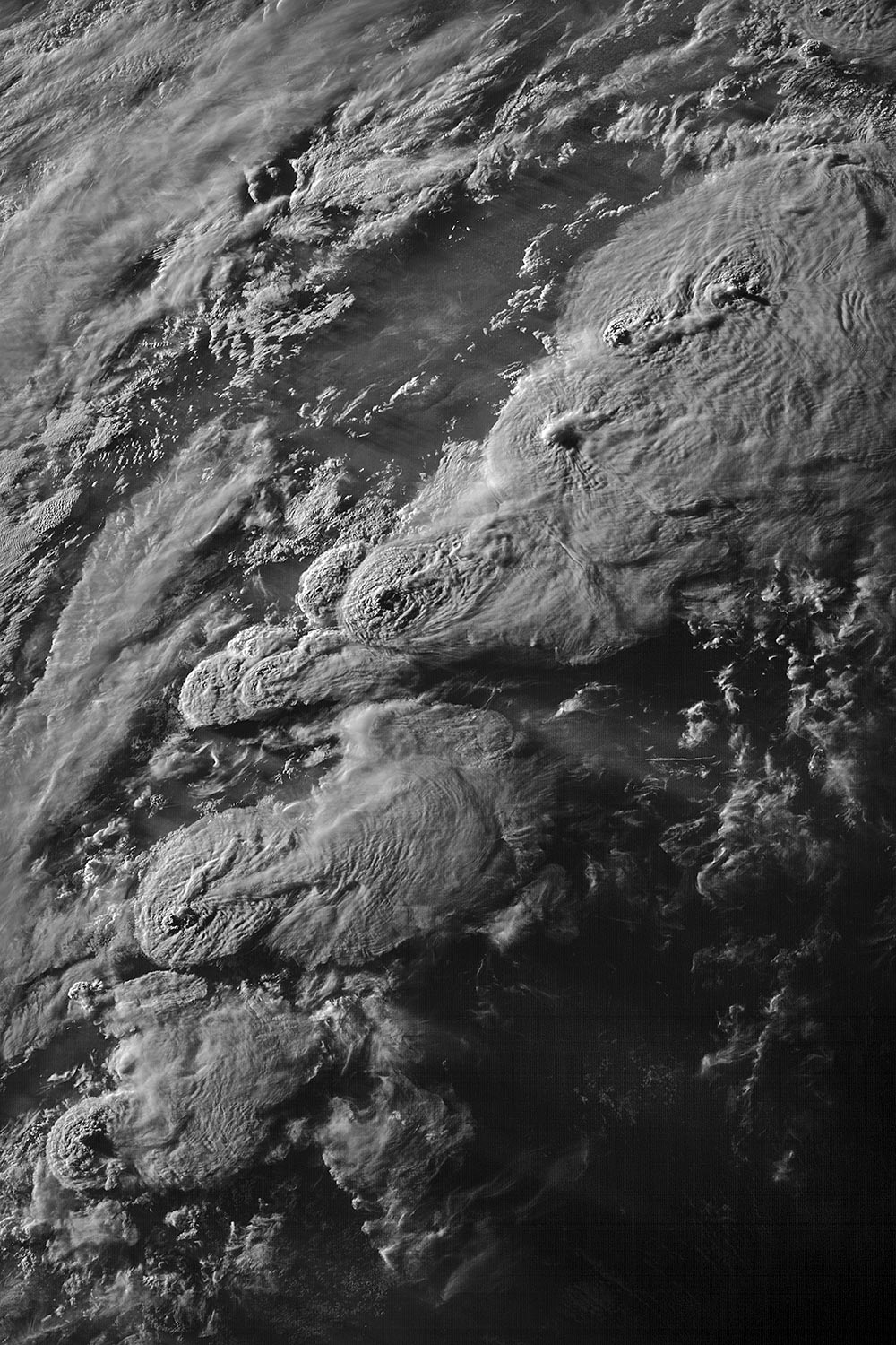
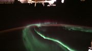
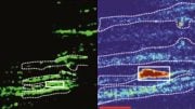
A string of storms producing AACPs on May 27, 2021, over the Southern and Central Great Plains. Credit: Kelton Halbert/NOAA/NASA
Understanding how and why plumes take shape above powerful thunderstorms could help forecasters recognize similar impending dangers and issue more accurate warnings without relying on Doppler radar systems, which can be knocked out by wind and hail – and have blind spots even on good days. In many parts of the world, Doppler radar coverage is nonexistent.
“If there’s going to be a terrible hurricane, we can see it from space. We can’t see tornadoes because they’re hidden below thunderstorm tops. We need to understand the tops better,” said O’Neill, who is an assistant professor of Earth system science at Stanford’s School of Earth, Energy & Environmental Sciences (Stanford Earth).
Supercell storms and exploding turbulence
The thunderstorms that spawn most tornadoes are known as supercells, a rare breed of storm with a rotating updraft that can hurtle skyward at speeds faster than 150 miles an hour, with enough power to punch through the usual lid on Earth’s troposphere, the lowest layer of our atmosphere.
In weaker thunderstorms, rising currents of moist air tend to flatten and spread out upon reaching this lid, called the tropopause, forming an anvil-shaped cloud. A supercell thunderstorm’s intense updraft presses the tropopause upward into the next layer of the atmosphere, creating what scientists call an overshooting top. “It’s like a fountain pushing up against the next layer of our atmosphere,” O’Neill said.
As winds in the upper atmosphere race over and around the protruding storm top, they sometimes kick up streams of water vapor and ice, which shoot into the stratosphere to form the tell-tale plume, technically called an Above-Anvil Cirrus Plume, or AACP.
The rising air of the overshooting top soon speeds back toward the troposphere, like a ball that accelerates downward after cresting aloft. At the same time, air is flowing over the dome in the stratosphere and then racing down the sheltered side.
Using computer simulations of idealized supercell thunderstorms, O’Neill and colleagues discovered that this excites a downslope windstorm at the tropopause, where wind speeds exceed 240 miles per hour. “Dry air descending from the stratosphere and moist air rising from the troposphere join in this very narrow, crazy-fast jet. The jet becomes unstable and the whole thing mixes and explodes in turbulence,” O’Neill said. “These speeds at the storm top have never been observed or hypothesized before.”
Hydraulic jump
Scientists have long recognized that overshooting storm tops of moist air rising into the upper atmosphere can act like solid obstacles that block or redirect airflow. And it’s been proposed that waves of moist air flowing over these tops can break and loft water into the stratosphere. But no research to date has explained how all the pieces fit together.
The new modeling suggests the explosion of turbulence in the atmosphere that accompanies plumed storms unfolds through a phenomenon called a hydraulic jump. The same mechanism is at play when rushing winds tumble over mountains and generate turbulence on the downslope side, or when water speeding smoothly down a dam’s spillway abruptly bursts into froth upon joining slower-moving water below.
Leonardo DaVinci observed the phenomenon in flowing water as early as the 1500s, and ancient Romans may have sought to limit hydraulic jumps in aqueduct designs. But until now atmospheric scientists have only seen the dynamic induced by solid topography. The new modeling suggests a hydraulic jump can also be triggered by fluid obstacles in the atmosphere made almost entirely of air and which are changing shape every second, miles above the Earth’s surface.
The simulations suggest the onset of the jump coincides with a surprisingly rapid injection of water vapor into the stratosphere, upwards of 7000 kilograms per second. That’s two to four times higher than previous estimates. Once it reaches the overworld, water may stay there for days or weeks, potentially influencing the amount and quality of sunlight that reaches Earth via destruction of ozone in the stratosphere and warming the planet’s surface. “In our simulations that exhibit plumes, water reaches deep into the stratosphere, where it possibly could have more of a long-term climate impact,” said co-author Leigh Orf, an atmospheric scientist at the University of Wisconsin-Madison.
According to O’Neill, high-altitude NASA research aircraft have only recently gained the ability to observe the three-dimensional winds at the tops of thunderstorms, and have not yet observed AACP production at close range. “We have the technology now to go verify our modeling results to see if they’re realistic,” O’Neill said. “That’s really a sweet spot in science.”
Reference: “Hydraulic jump dynamics above supercell thunderstorms” by Morgan E O’Neill, Leigh Orf, Gerald M. Heymsfield and Kelton Halbert, 10 September 2021, Science.
DOI: 10.1126/science.abh3857
This research was supported by the National Science Foundation and the NASA Precipitation Measurement Mission and Ground Validation program.
O’Neill is also a center fellow (by courtesy) of Stanford Woods Institute for the Environment. Additional co-authors are affiliated with Cooperative Institute for Meteorological Satellite Studies in Madison, Wis.; and NASA Goddard Space Flight Center in Greenbelt, Md.
What goes UP, must come DOWN. Patent, elementary Physics. But CAUSE and EFFECT are often a more tangled relationship. This clarification is greatly appreciated. I am neither an atmospheric Scientist nor a meteorologist, nor would I want to be. Turning a vested interest into a JOB doesn’t work for me. Too much would be lost to the practical bargain of Time, against what is essentially “sacred” knowledge, Scientific writ aside. I can speak with some “authority” on the volatility of thunderstorm cells: I was flying second seat, transporting a twin-engine, Beachcraft Baron from Western NY to Philadelphia, PA. Somewhere south of the State Line, we passed in close proximity to a thunderstorm cell. We were vectored to the West of the cell. As we passed, a massive, fast-moving downdraft (in excess of 180 knots, estimated post event), spilling off the upwind side of the Column, caught us. We stalled (zero lift, zero airspeed) and, after a “pregnant” millisecond or three, set into a flat spin, headed for the ground, riding the down-burst. Luckily, the pilot, a veteran AIR FORCE pilot who “flew through” The Nam in an A-37B Dragonfly, still had his shyte together. “Keep a tight sphincter”, he cautioned, and we rode it down to within about 1800 ft (from Angels 9), where the downdraft turned to updraft after impacting the ground. He neutralized the controls, restarted the engines, and we (essentially) side-slipped out of there to the West. This experience “solidified” my perception of the Order of Nature, and how “mere” Humans harness knowledge to suborn that same Nature, not in its essential principles, but in the attempt to defeat and/or comprehend the probabilities induced of its essentially mindless CAUSE against the desired EFFECT: survival.
Thank you, again.
🦋