
NASA’s Curiosity Mars rover used its Mast Camera, or Mastcam, to capture this 360-degree view on July 3, 2021. The panorama is made up of 129 individual images that were sent to Earth, after which they are stitched together. Credit: NASA/JPL-Caltech/MSSS
A new video rings in the rover’s ninth year on Mars, letting viewers tour Curiosity’s location on a Martian mountain.
Images of knobbly rocks and rounded hills are delighting scientists as NASA’s Curiosity rover climbs Mount Sharp, a 5-mile-tall (8-kilometer-tall) mountain within the 96-mile-wide (154-kilometer-wide) basin of Mars’ Gale Crater. The rover’s Mast Camera, or Mastcam, highlights those features in a panorama captured on July 3, 2021 (the 3,167th Martian day, or sol, of the mission).
This location is particularly exciting: Spacecraft orbiting Mars show that Curiosity is now somewhere between a region enriched with clay minerals and one dominated by salty minerals called sulfates. The mountain’s layers in this area may reveal how the ancient environment within Gale Crater dried up over time. Similar changes are seen across the planet, and studying this region up close has been a major long-term goal for the mission.
“The rocks here will begin to tell us how this once-wet planet changed into the dry Mars of today, and how long habitable environments persisted even after that happened,” said Abigail Fraeman, Curiosity’s deputy project scientist, at NASA’s Jet Propulsion Laboratory in Southern California.
This video tour highlights a new panorama from NASA’s Curiosity Mars rover, captured on July 3, 2021 (the 3,167th Martian day, or sol of the mission). Credit: NASA/JPL-Caltech/MSSS
Nine Years on Mars
Curiosity landed nine years ago, on August 5, 2012 PDT (August 6, 2012 EDT), to study whether different Martian environments could have supported microbial life in the planet’s ancient past, when lakes and groundwater existed within Gale Crater.
The rover pulverizes rock samples with a drill on its robotic arm, then sprinkles the powder into the rover’s chassis, where a pair of instruments determines which chemicals and minerals are present. Curiosity recently drilled its 32nd rock sample from a target nicknamed “Pontours” that will help detail the transition from the region of clay minerals to the one dominated by sulfates.
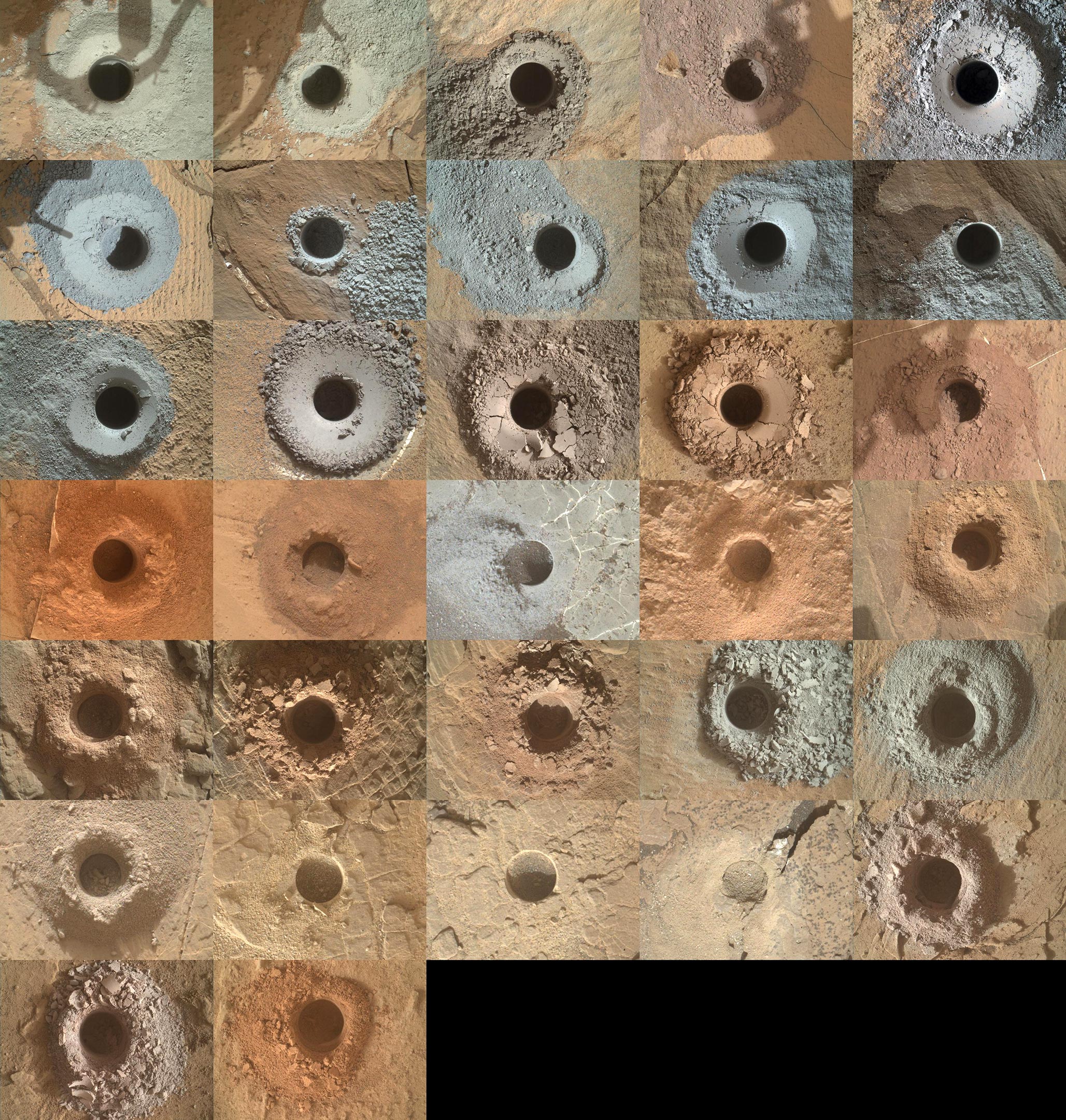
NASA’s Curiosity Mars rover has used the drill on its robotic arm to take 32 rock samples to date. The Mars Hand Lens Imager (MAHLI), a camera on the end of the robotic arm, provided the images in this mosaic. Credit: NASA/JPL-Caltech/MSSS
Because it’s winter at Curiosity’s location, the skies in the new panorama are relatively dust-free, providing a clear view all the way down to Gale Crater’s floor. It’s provided an opportunity for the mission team to reflect on the 16 miles (26 kilometers) Curiosity has driven during the mission.
“Landing day is still one of the happiest days of my professional career,” said the mission’s new project manager, Megan Richardson Lin of NASA’s Jet Propulsion Laboratory in Southern California. Lin started working on Curiosity just before it launched, joining the surface operations team shortly afterward. She’s held several roles on the mission since then. “We’re driving a robot as it explores another planet. Seeing how new discoveries and scientific results guide each day’s activities is extremely rewarding.”
There’s more to discover on the road ahead. Curiosity has already started up a path winding between “Rafael Navarro Mountain,” recently nicknamed to honor a deceased mission scientist, and a towering butte that’s taller than a four-story building. In the coming year, the rover will drive past these two features into a narrow canyon before revisiting the “Greenheugh Pediment,” a slope with a sandstone cap that the rover briefly summited last year.


What happened in Mars once is applicable to Earth too. I do call it : The Gravitational Collapse of planet. Unlike the stars, the role of gravity is small. The gravity will still be the weakest force.But a shift in it can see the disappearance of water, overnight.
Your Blue sky is showing idiots.
Its earth.
Where is the science. Lots of stupid pictures that could be from anywhere. NASA lies and lies. All they care about is getting funding. Just like the rest of us.
No ethics. No fear of discovery. The narrative is all theirs to write. With the press in the pocket of big finance, you get fed sh*t and kept in the dark…bunch of mushrooms we are.