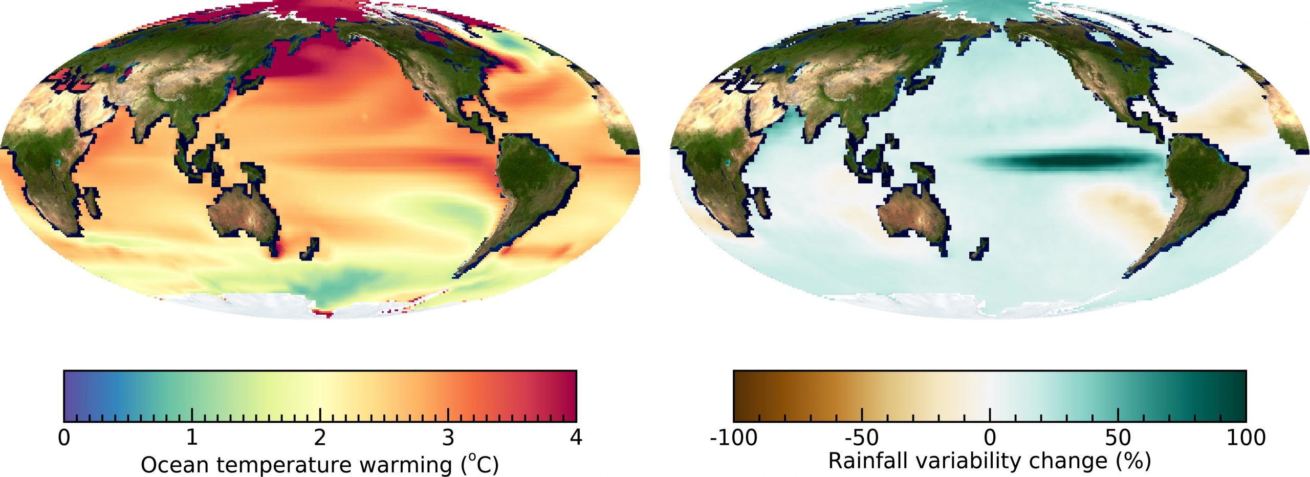
(Left) Predicted change of ocean surface temperature in 2050-2099 relative to 1950-1999 using an ensemble of climate models. (Right) Predicted change in amplitude of rainfall fluctuations (year-to-year standard deviation) in 2050-2099 relative to 1950-1999. Credit: Kyung-Sook Yun
Ocean warming predicted to cause a twofold increase in amplitude of rainfall fluctuations over the tropical Pacific.
The El Niño-Southern Oscillation (ENSO) is the most energetic naturally occurring year-to-year variation of ocean temperature and rainfall on our planet. The irregular swings between warm and wet “El Niño” conditions in the equatorial Pacific and the cold and dry “La Niña” state influence weather conditions worldwide, with impacts on ecosystems, agriculture, and economies. Climate models predict that the difference between El Niño- and La Niña-related tropical rainfall will increase over the next 80 years, even though the temperature difference between El Niño and La Niña may change only very little in response to global warming. A new study published in Communications Earth & Environment uncovers the reasons for this surprising fact.
Using the latest crop of climate models, researchers from the IBS Center for Climate Physics at Pusan National University, the Korea Polar Research Institute, the University of Hawai’i at Mānoa, and Environment and Climate Change Canada, worked together to unravel the mechanisms involved. “All climate models show a pronounced intensification of year-to-year tropical rainfall fluctuations in response to global warming.” says lead author Dr. Kyung-Sook Yun from the IBS Center for Climate Physics (Image, right panel). “Interestingly the year-to-year changes in ocean temperature do not show such a clear signal. Our study therefore focuses on the mechanisms that link future ocean warming to extreme rainfall in the tropical Pacific,” she goes on to say.
The research team found that the key to understanding this important climatic feature lies in the relationship between tropical ocean surface temperature and rainfall. There are two important aspects to consider: 1) the ocean surface temperature threshold for rainfall occurrence, and 2) the rainfall response to ocean surface temperature change, referred to as rainfall sensitivity. “In the tropics, heavy rainfall is typically associated with thunderstorms and deep clouds shaped like anvils. These only form once the ocean surface is warmer than approximately 27.5 degrees Celsius or 81 degrees Fahrenheit in our current climate,” says co-author Prof. Malte Stuecker from the University of Hawai’i at Mānoa.
This ocean surface temperature threshold for intense tropical rainfall shifts towards a higher value in a warmer world and does not contribute directly to an increase in rainfall variability. “However, a warmer atmosphere can hold more moisture which means that when it rains, rainfall will be more intense. Moreover, enhanced warming of the equatorial oceans leads to upward atmospheric motion on the equator. Rising air sucks in moist air from the off-equatorial regions, which can further increase precipitation, in case other meteorological conditions for a rain event are met.” says co-lead author Prof. June-Yi Lee from IBS Center for Climate Physics.
This increase in rainfall sensitivity is the key explanation for why there will be more extreme ENSO-related swings in rainfall in a warmer world.
Reference: “Increasing ENSO–rainfall variability due to changes in future tropical temperature–rainfall relationship” by Kyung-Sook Yun, June-Yi Lee, Axel Timmermann, Karl Stein, Malte F. Stuecker, John C. Fyfe and Eui-Seok Chung, 22 February 2021, Communications Earth & Environment.
DOI: 10.1038/s43247-021-00108-8


Once again, an un-vetted model, which should be of academic interest only, is trotted out to warn about impending problems. Global Circulation Models (GCM) are ‘tuned’ with fudge factors to approximate the past in the hope that the future projections will be correct; however, most run warm. Anyone who is familiar with using least-squares regression to fit a polynomial function to a time-series, knows full well that while the fit is good within the limits of the available data, extrapolations are very unreliable; they can, and often do, diverge in directions and rates that are un-physical.
There are many natural feed-back systems that constrain what can happen in ocean and air. I wonder if the precipitation modelers considered those for this Nostradamus-worthy forecast? One of the issues is that while warm air may hold more water vapor, will it precipitate out in deluges, or just rain for a longer period of time? Will the increased rainfall result in local cooling as a result of transfer of latent heat of evaporation? Did the modelers attempt to include that effect in their models, or just rely on the GCM predictions?
I’m all for using computer models to try to understand dynamic systems. However, one should recognize their limitations and remember that they are research tools, not reality.
I loved Clyde Spencer’s analysis. That’s science not the usual rubbish written everywhere by amateurs.
Thank you, Gerald. I wish that the articles were above reproach. Unfortunately, it seems that most articles that are about climatology are of poor research design and the conclusions are often not warranted. It seems that most of today’s young scientists have never read Chamberlain’s “Method of Multiple Working Hypotheses.” Fortunately, it was required undergraduate reading for me, and I have taken it to heart.