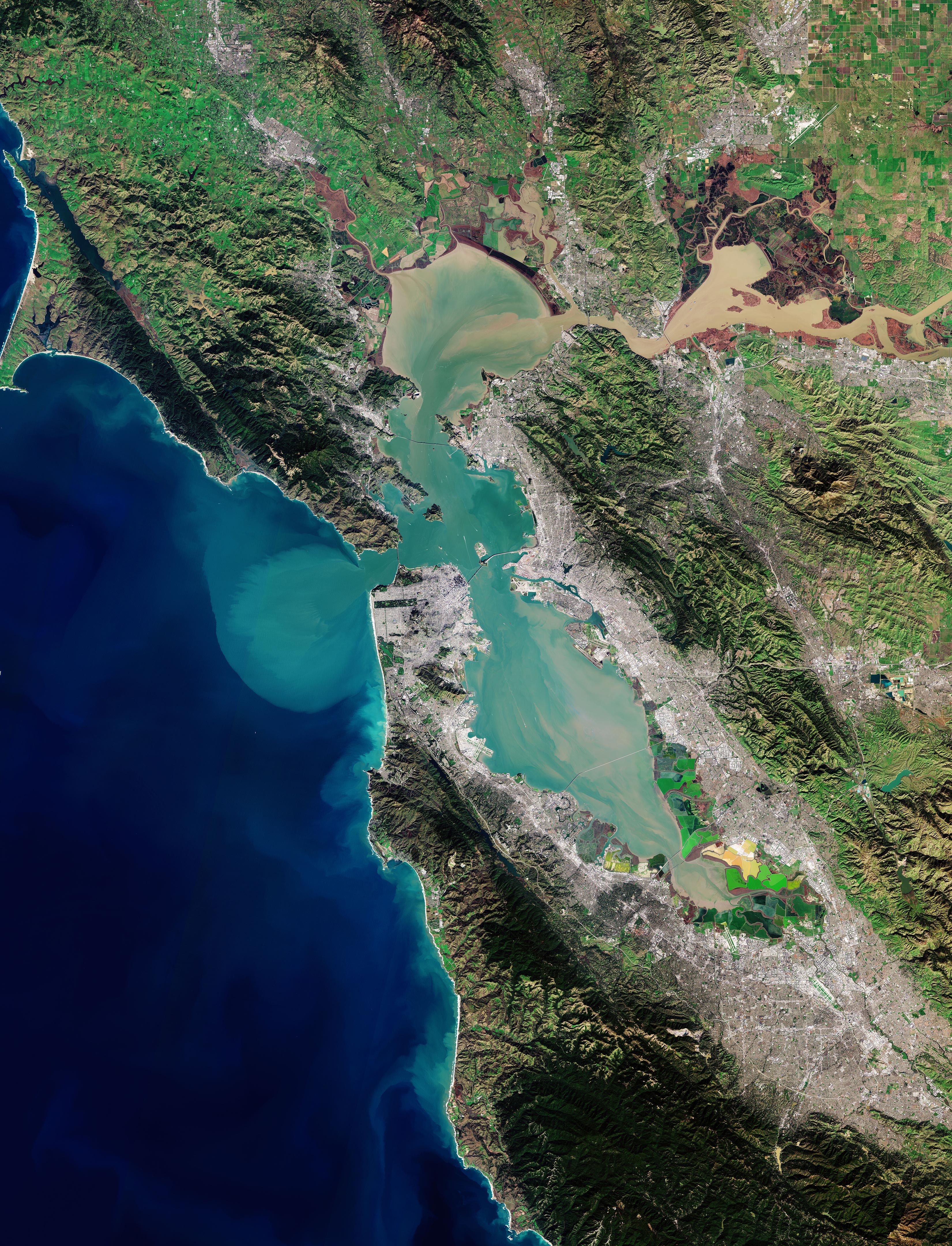
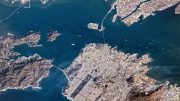
(Click image for full view.) San Francisco Bay captured on January 25, 2019, by the Copernicus Sentinel-2 mission. Credit: Contains modified Copernicus Sentinel data (2019), processed by ESA, CC BY-SA 3.0 IGO
The Copernicus Sentinel-2 mission takes us over San Francisco Bay in the US state of California.
San Francisco Bay, almost 100 km (62 mi) in length, is a shallow estuary surrounded by the San Francisco Bay Area – an extensive metropolitan region that is dominated by large cities such as San Francisco, Oakland, and San Jose. The densely populated urban areas around the bay contrast strongly with the surrounding green forest and park areas.
In the upper right of the image, the delta of the Sacramento and San Joaquin rivers is visible – with the brown, sediment-filled water flowing down into San Pablo Bay. Here, the murky waters mix before flowing into the larger bay area, which is connected to the Pacific Ocean via the Golden Gate Strait. A large sediment plume can be seen traveling westward into the Pacific in the left of the image.
The Golden Gate Bridge, around 2.7 km(1.7 mi) long, is visible crossing the opening of the bay into the Pacific Ocean between Marin County and the city of San Francisco – which can be seen at the tip of the southern peninsula in the center of the image. Treasure, Angel, and Alcatraz islands can be seen sticking out of the waters of the bay, with several bridges connecting its east and west shores. Several boats are also visible.
The bright green and yellow colors in the bottom right of the image are salt ponds and are part of the Don Edwards National Wildlife Refuge. Covering an area of around 120 sq km (46 sq mi), the refuge contains salt marsh, mudflat, and vernal pool habitats for millions of migratory birds and endangered species.
Sentinel-2 is a two-satellite mission to supply the coverage and data delivery needed for Europe’s Copernicus program. The mission’s frequent revisits over the same area and high spatial resolution allow changes in water bodies to be closely monitored.

Very nice view. I loved him so much 💞💞💞
I was waiting for a statement on how often it is clear enough to get this shot as I suspect it has a lot of smog?
Most all the waist treatment plants are aling the bay water discharging into the bay. Although the water been treated it still polluted
I have a 1986 San Francisco Bay From Space poster that says (Cultivate Understanding Poster)
I was wondering if there was any value here. Thanks for your time, Wendy.