
Central Alps of Switzerland have been lifted to today’s height. Credit: ETH Zurich
ETH researchers have used a computer model to test a new hypothesis about the formation of the Alps while simulating seismic activity in Switzerland. This will help improve current earthquake risk models.
For a long time, geoscientists have assumed that the Alps were formed when the Adriatic plate from the south collided with the Eurasian plate in the north. According to the textbooks, the Adriatic plate behaved like a bulldozer, thrusting rock material up in front of it into piles that formed the mountains. Supposedly, their weight subsequently pushed the underlying continental plate downwards, resulting in the formation of a sedimentary basin in the north adjacent to the mountains – the Swiss Molasse Plateau. Over time, while the mountains grew higher the basin floor sank deeper and deeper with the rest of the plate.
A few years ago, however, new geophysical and geological data led ETH geophysicists Edi Kissling and Fritz Schlunegger, a sediment specialist from the University of Bern, to express doubts about this theory. In light of the new information, the researchers postulated an alternative mechanism for the formation of the Alps.
Altitude of the Alps has barely changed
Kissling and Schlunegger pointed out that the topography and altitude of the Alps have barely changed over the past 30 million years, and yet the trench at the site of the Swiss Plateau has continued to sink and the basin extended further north. This leads the researchers to believe that the formation of the Central Alps and the sinking of the trench are not connected as previously assumed. They argue that if the Alps and the trench indeed had formed from the impact of two plates pressing together, there would be clear indications that the Alps were steadily growing. That’s because, based on the earlier understanding of how the Alps formed, the collision of the plates, the formation of the trench, and the height of the mountain range are all linked. Furthermore, seismicity observed during the past 40 years within the Swiss Alps and their northern foreland clearly documents extension across the mountain ranges rather than the compression expected for the bulldozing Adria model.
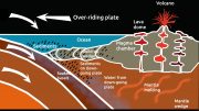
The behavior of the Eurasian plate provides a possible new explanation. Since about 60 Ma ago, the former oceanic part of the Eurasian plate sinks beneath the continental Adriatic microplate in the south. By about 30 Ma ago, this process of subduction is so far advanced that all oceanic lithosphere has been consumed and the continental part of the Eurasian plate enters the subduction zone. This denotes the beginning of the so-called continent-continent collision with the Adriatic microplate and the European upper, lighter crust separates from the heavier, underlying lithospheric mantle. Because it weighs less, the Earth’s crust surges upwards, literally creating the Alps for the first time around 30 Ma ago. While this is happening, the lithospheric mantle sinks further into the Earth’s mantle, thus pulling the adjacent part of the plate downwards.
This theory is plausible because the Alps are mainly made up of gneiss and granite and their sedimentary cover rocks like limestone. These crustal rocks are significantly lighter than the Earth’s mantle – into which the lower layer of the plate, the lithospheric mantle, plunges after the detachment of the two layers that form the continental plate. “In turn, this creates strong upward forces that lift the Alps out of the ground,” Kissling explains. “It was these upward forces that caused the Alps to form, not the bulldozer effect as a result of two continental plates colliding,” he says.
New model confirms lift hypothesis
To investigate the lift hypothesis, Luca Dal Zilio, a former doctoral student in ETH geophysics professor Taras Gerya’s group, has now teamed up with Kissling and other ETH researchers to develop a new model. Dal Zilio used ETH’s Euler mainframe to simulate the subduction zone under the Alps: the plate tectonic processes, which took place over millions of years, and the associated earthquakes.
“The big challenge with this model was bridging the time scales. It takes into account lightning-fast shifts that manifest themselves in the form of earthquakes, as well as deformations of the crust and lithospheric mantle over thousands of years,” says Dal Zilio, lead author of the study recently published in the journal Geophysical Review Letters.
Five important stages in the orogeny:
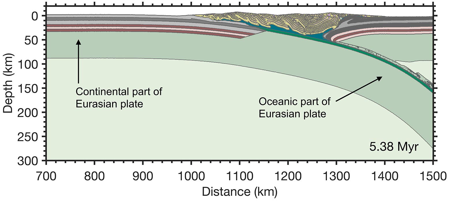
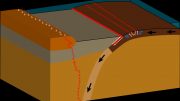
Thirty-seven million years ago, subduction of the heavier oceanic part of the Eurasian Plate (from the left) under the lighter continental Adriatic Plate (right) in the south is in full swing. A shallow “mountain range” (yellow, striped area) forms above the zone where the plates converge, initially as isolated islands that barely protrude above sea level. Light green area: Earth’s mantle; green band: lithosphere; dark green, narrow band: oceanic crust; pink/ruby red bands: lower crust; grey bands: upper crust.

Over millions of years, the oceanic plate becomes increasingly curved, practically curling in on itself. The Eurasian plate as a whole remains stationary. This causes the subducting plate to start exerting a suction effect on the much smaller Adriatic plate, pulling it northwards (to the left in the diagram).

Continent-Continent Collision. When this process of subduction is so far advanced that the lighter, continental part of the Eurasian plate enters the subduction zone and begins to collide with the Adriatic microplate, the subduction process slows down. The buoyant continental part of the Eurasian plate resists being subducted while the previously subducted oceanic part continues to pull downward leading to steepening of the slab and eventually to the necking of the plate and the beginning of the separation of the upper, lighter crust from the heavier, underlying lithospheric mantle.

Post-collisional evolution I. A decisive moment takes place 30 million years ago when the oceanic part of the subducted plate breaks away. This reduces its tremendous weight. It relaxes like a leaf spring and retracts. This enhances the lifting effect on the mountains, causing them to rise almost to their present height. At the same time, however, the continuing separation of the Eurasian continental crust from its mantle lithosphere allows the latter to further sink into the mantle.
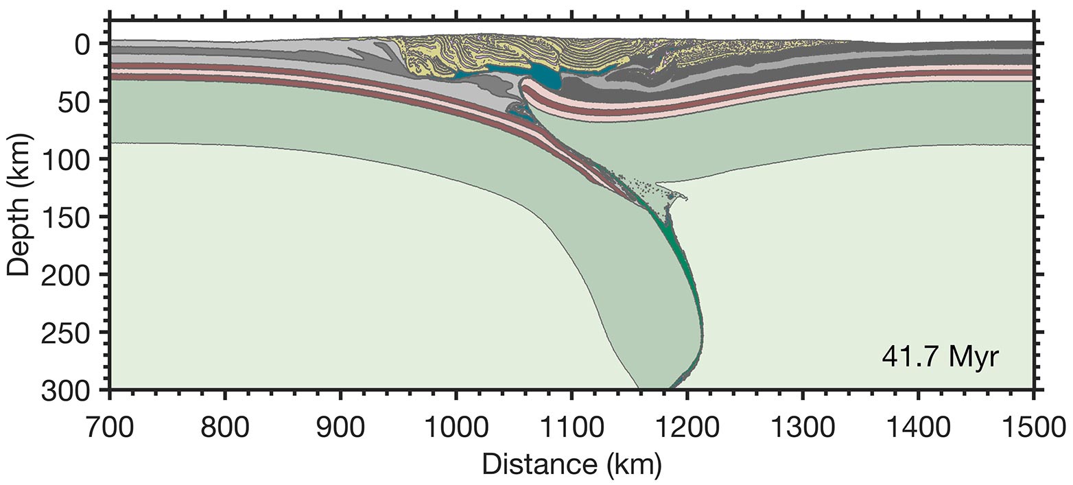
Post-collisional evolution II. Subduction of the mantle lithosphere of the Eurasian plate continues, albeit at a slower rate and controlled by the rate of detachment of the buoyant crust. By suction forces, the Adriatic plate is pulled further northwards. On the surface, the effects of uplift and erosion balance each other out, meaning that the Alps have remained at about the same height for the last 30 million years.
The entire process as video Credit: Dal Zilio et al, Geophys.Res.Letters, 2020
According to Kissling, the model is an excellent way to simulate the uplifting processes that he and his colleague are postulating. “Our model is dynamic, which gives it a huge advantage,” he says, explaining that previous models took a rather rigid or mechanical approach that did not take into account changes in plate behavior. “All of our previous observations agree with this model,” he says.
The model is based on physical laws. For instance, the Eurasian plate would appear to subduct southwards. In contrast to the normal model of subduction, however, it doesn’t actually move in this direction because the position of the continent remains stable. This forces the subducting lithosphere to retreat northwards, causing the Eurasian plate to exert a suction effect on the relatively small Adriatic plate. Kissling likens the action to a sinking ship. The resulting suction effect is very strong, he explains. Strong enough to draw in the smaller Adriatic microplate so that it collides with the crust of the Eurasian plate. “So, the mechanism that sets the plates in motion is not in fact a pushing effect but a pulling one,” he says, concluding that the driving force behind it is simply the pull of gravity on the subducting plate.
Rethinking seismicity
In addition, the model simulates the occurrence of earthquakes, or seismicity, in the Central Alps, the Swiss Plateau, and below the Po Valley. “Our model is the first earthquake simulator for the Swiss Central Alps,” says Dal Zilio.
According to the model, seismic activity below the Alps varies significantly from that below the Swiss Plateau, the Jura Mountains, and the Po Valley. It shows that earthquakes occur more frequently and at shallower depths below the Alps; below the Swiss Plateau and the Jura, by contrast, they occur less frequently and at greater depths. Furthermore, the new model explains the extension-dominated seismicity within the mountain range whereas the seismicity in the upper crust beneath the forelands exhibits compression. According to Kissling, the model is an excellent way to simulate the uplifting processes that he and his colleague are postulating. “Our model is dynamic, which gives it a huge advantage,” he says, explaining that previous models took a rather rigid or mechanical approach that did not take into account changes in plate behavior. “All of our previous observations agree with this model,” he says.
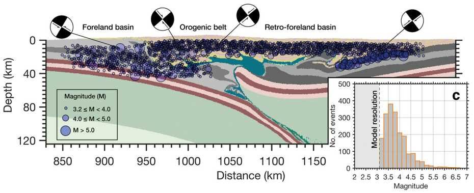
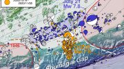
Clusters of seismicity display a broad pattern of different styles of faulting, which are consistent with the local tectonic regime. Credit: Dal Zilio et al, Geophys. Res. Letters, 2020
The advantage of this earthquake simulator is that it covers a very long period of time, meaning that it can also simulate very strong earthquakes that occur extremely rarely.
“Current seismic models are based on statistics,” Dal Zilio says, “whereas our model uses geophysical laws and therefore also takes into account earthquakes that occur only once every few hundreds of years.” Current earthquake statistics tend to underestimate such earthquakes. The new simulations therefore improve the assessment of earthquake risk in Switzerland.
Reference: “Slab Rollback Orogeny Model: A Test of Concept” by Luca Dal Zilio, Edi Kissling, Taras Gerya and Ylona van Dinther, 25 August 2020, Geophysical Research Letters.
DOI: 10.1029/2020GL089917
The model was created as part of the AlpArray initiative, which aims to advance understanding of how the Alps formed and of seismic risk in the region. As part of the project, scientists from 11 countries and 36 institutions installed 600 sensors all over the Alps. Together, the participants operate the largest academic seismographic network in the world. AlpArray is supported by the Swiss National Science Foundation.


Extremely interesting.
Major breakthrough in Earthquake and Geological Sciences.
This simulator may be applicable to both instances where the Mountains are rising (like Everest) and also where they are not. Not sure if its is broad enough to be applicable to instances where the tectonic plates are scraping against each other. Like reportedly happening in California.
Should be appied to all Major and Minor Tectonic Plates and used for Earthquake forccasting and moving away from pobabilistic forecasting to remove uncertainty. May save many lives.
Watching California Fires, Repeated Earthquakes with concern. Develop a Simulator for all possible instances please.
Finally on a lighter note, remember the classic movie ” Sound of Music” and the Von Trapp Family and Julie Andrews singing , “Climb every mountain” , and “How do you solve a problem like Maria” picturised in the beautiful Alps. Certainly on our list of places to visit before we kick the bucket.
The problem with Science is a lot of Science is based on assumptions made by earilier generations and making an ASS UM pt Ion makes an ASS out of You, Me & I. Probabilistic
and statistical methodoligies and Science has its uses, but introduces uncertainty into the picture. So Data Science in alignment with the laws of physics is probably much better. Ofcourse we still dont now all the laws of physics especially at the quantum level,
Another THought.
Why cant we build in Fire Reatrdants into the Forests and Greenary getting destroyed every year or adopt forestry technologies and practices which will minimize such loss of flora and fauna on a gaint scale ?
“… adopt forestry technologies and practices which will minimize such loss of flora and fauna on a gaint scale?”
That’s why foresters thin forests and use controlled burns in an attempt to reduce the fuel. They also maintain bombers to drop fire retardant on small fires, in the hopes of preventing them from becoming conflagrations. Unfortunately, sometimes these common sense activities are opposed by self-appointed stewards of the land who have no background in forestry.
Over tens of millions yrs forests evolved with occasional fires. So if you stop fires you will fundamentally change healthy forests to something else.
The diagrams are absolutely rotten. Close to eight percent of the audience has no chance to understand them because they use shades of green and red that are indistinguishable for those with color vision deficiency. EIGHT PERCENT of people just don’t count. There is insufficient reason to highlight the key features using shades of red and green, and certainly no justifiable reason to use the faint hues rather than vivid ones. Good lord, if they want to keep the diagrammed information secret, they could just refuse to publish. What a poor example of public communication!