
Close Menu
    Facebook X (Twitter) Instagram
    SciTechDaily
    • Biology
    • Chemistry
    • Earth
    • Health
    • Physics
    • Science
    • Space
    • Technology
    Facebook X (Twitter) Pinterest YouTube RSS
    SciTechDaily
    Home»Earth»NASA’s Terra Satellite Sees Arizona’s Massive Bighorn Fire Burn Scar From Space
    Earth

    NASA’s Terra Satellite Sees Arizona’s Massive Bighorn Fire Burn Scar From Space

    By Jet Propulsion LaboratoryJuly 1, 2020No Comments3 Mins Read
    Facebook Twitter Pinterest Telegram LinkedIn WhatsApp Email Reddit
    Share
    Facebook Twitter LinkedIn Pinterest Telegram Email Reddit
    Arizona Bighorn Fire Burn Scar
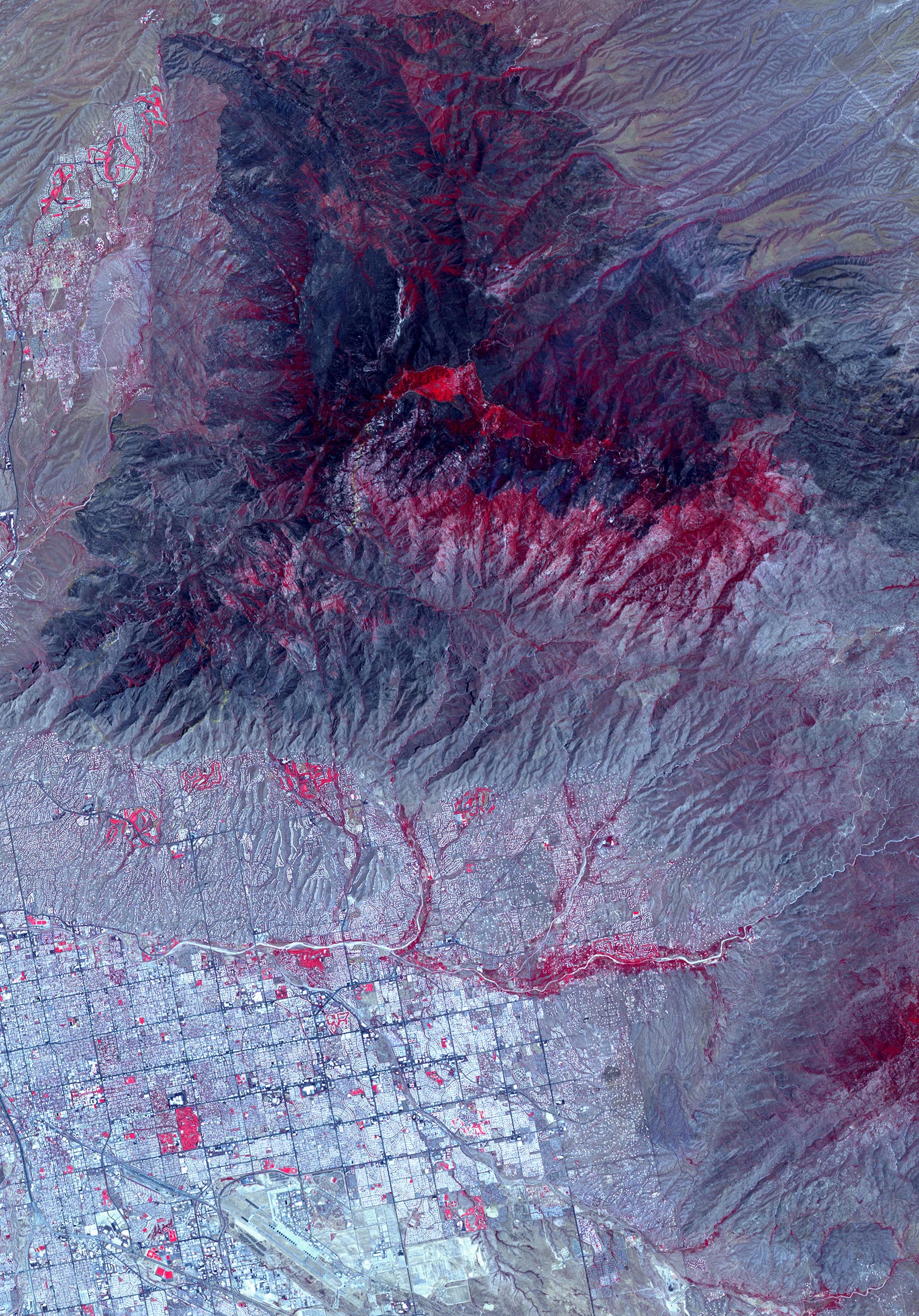
    (Click image for full view.) NASA’s Advanced Spaceborne Thermal Emission and Reflection Radiometer (ASTER) instrument imaged areas burned by the Bighorn Fire north of Tucson, Arizona, on June 29. Vegetation is shown in red and burned areas are shown in dark gray. It covers an area of 20 by 30 miles (33 by 48 kilometers). Credit: NASA

    From the vantage point of the Terra satellite, the instrument can detect the scarred land that the wildfire, burning north of Tucson, is leaving in its wake.

    On the night of June 5, a lightning strike started the Bighorn Fire in the Santa Catalina Mountains north of Tucson, Arizona. Extremely dry vegetation and windy conditions caused the fire to spread quickly. By June 30, the multi-agency incident information system, InciWeb, reported that it had ballooned to more than 114,000 acres (461 square kilometers)  and that it was about 45% contained.

    NASA’s Advanced Spaceborne Thermal Emission and Reflection Radiometer (ASTER) instrument aboard the Terra satellite imaged some of the burned areas on June 29. In this image, vegetation is shown in red and burned areas appear dark gray. It covers an area of 20 by 30 miles (33 by 48 kilometers).

    Efforts to contain the fire continue with 21 hand crews, 10 helicopters, and dozens of fire engines deployed to the area. Smoke impacts to surrounding communities are being carefully monitored.

    With its 14 spectral bands from the visible to the thermal infrared wavelength region and its high spatial resolution of about 50 to 300 feet (15 to 91 meters), ASTER images Earth to map and monitor the changing surface of our planet. It is one of five Earth-observing instruments launched on December 18, 1999, on Terra. The instrument was built by Japan’s Ministry of Economy, Trade and Industry. A joint U.S./Japan science team is responsible for the validation and calibration of the instrument and data products.

    The broad spectral coverage and high spectral resolution of ASTER provide scientists in numerous disciplines with critical information for surface mapping and monitoring of dynamic conditions and temporal change. Example applications are monitoring glacial advances and retreats; monitoring potentially active volcanoes; identifying crop stress; determining cloud morphology and physical properties; wetlands evaluation; thermal pollution monitoring; coral reef degradation; surface temperature mapping of soils and geology; and measuring surface heat balance.

    The U.S. science team is located at NASA’s Jet Propulsion Laboratory in Southern California. The Terra mission is part of NASA’s Science Mission Directorate, Washington.

    Never miss a breakthrough: Join the SciTechDaily newsletter.
    Follow us on Google and Google News.

    JPL NASA Wildfires
    Share. Facebook Twitter Pinterest LinkedIn Email Reddit

    Related Articles

    California Fire Led To Spike in Fecal Bacteria in Coastal Waters

    NASA’s MISR Sees California Wildfire Smoke Plumes Traveling Miles Into the Atmosphere

    NASA Takes Flight to Study California’s Wildfire Damage With Smoke-Penetrating Technology

    NASA Monitors Atmospheric Carbon Monoxide From California Wildfires

    NASA Tracks California’s Wildfires From Space and in the Air

    NASA: Amazon Fires Were Fueled by Drought-Stressed Forest

    NASA’s Terra Satellite Images California’s Kincade Fire Burn Scar From Space

    NASA’s ECOSTRESS Detects Amazon Fires from International Space Station

    Carbon Monoxide From Brazil Fires Mapped by NASA Satellite

    Leave A Reply Cancel Reply

    • Facebook
    • Twitter
    • Pinterest
    • YouTube

    Don't Miss a Discovery

    Subscribe for the Latest in Science & Tech!

    Trending News

    Don’t Miss: A Brilliant Venus and Glowing Harvest Moon Light Up the Sky

    New Twist on the Einstein Problem Reveals Unexpected Physics

    JWST Captures Stunning Evidence of How Supermassive Black Holes Feed

    Early Exercise May Permanently Change How Much Energy the Body Uses To Move

    New Molecule Wipes Out Aggressive Lymphoma Tumors in Mice in Just 11 Days

    The Human Family Tree May Need a Major Rewrite

    Scientists Find a Surprising Cancer-Fighting Effect in Dark Sweet Cherries

    New AI Detects Hidden Warning Signs of Solar Eruptions Hours Before They Emerge

    Follow SciTechDaily
    • Facebook
    • Twitter
    • YouTube
    • Pinterest
    • Newsletter
    • RSS
    SciTech News
    • Biology News
    • Chemistry News
    • Earth News
    • Health News
    • Physics News
    • Science News
    • Space News
    • Technology News
    Recent Posts
    • Africa’s Giant Herbivores Were Disappearing Millions of Years Before Humans Could Hunt Them
    • This Utah Mountain Is Hiding Enough Ice To Fill 600 Olympic Pools
    • Vagus Nerve Stimulation Could Unlock the Brain’s Hidden Learning Potential
    • Your Mother’s Age May Leave a Biological Mark That Lasts for Generations
    • Women Who Ate More Antioxidants Had Strikingly Lower Rates of Cervical Cancer
    Copyright © 1998 - 2026 SciTechDaily. All Rights Reserved.
    • Science News
    • About
    • Contact
    • Editorial Board
    • Privacy Policy
    • Terms of Use

    Type above and press Enter to search. Press Esc to cancel.