Close Menu
    Facebook X (Twitter) Instagram
    SciTechDaily
    • Biology
    • Chemistry
    • Earth
    • Health
    • Physics
    • Science
    • Space
    • Technology
    Facebook X (Twitter) Pinterest YouTube RSS
    SciTechDaily
    Home»Earth»Exploring Earth From Space: Strait of Gibraltar
    Earth

    Exploring Earth From Space: Strait of Gibraltar

    By European Space Agency (ESA)March 13, 2021No Comments3 Mins Read
    Facebook Twitter Pinterest Telegram LinkedIn WhatsApp Email Reddit
    Share
    Facebook Twitter LinkedIn Pinterest Telegram Email Reddit
    Strait of Gibraltar
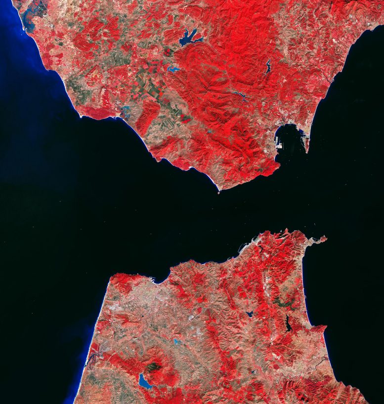
    The Strait of Gibraltar is featured in this false-color image captured by the Copernicus Sentinel-2 mission on October 28, 2020. Credit: Contains modified Copernicus Sentinel missions (2020), processed by ESA, CC BY-SA 3.0 IGO

    The Strait of Gibraltar is featured in this false-color image captured by the Copernicus Sentinel-2 mission.

    The Strait of Gibraltar connects the Mediterranean Sea with the Atlantic Ocean and separates southernmost Spain from northernmost Africa. The channel is 58 km (36 mi) long and narrows to 13 km (8 mi) in width between Point Marroquí (Spain) and Point Cires (Morocco). Ferries and vessels can be seen traveling across the strait and crossing between the two continents.

    This false-color image, captured on October 28, 2020, was processed in a way that included the near-infrared channel. This type of band combination from Copernicus Sentinel-2 is most commonly used to assess plant density and health, as plants reflect near-infrared and green light, while absorbing red. Since they reflect more near-infrared than green, dense, plant-covered land appears in bright red.

    Water bodies, such as the Mediterranean Sea and the Atlantic Ocean, appear in dark blue or black while turbid waters, such as those visible along the Spanish coast in the top-left of the image, appear in cyan or light blue. This is most likely due to sediment-laden waters flowing from rivers into the sea. Inland water bodies, such as the Barbate Reservoir visible at the top of the image, can be spotted in various shades of azure owing to their turbidity.

    Several prominent cities can be seen in the image in grey. These include Tangier, the port and principal city of northern Morocco which lies just 27 km (17 mi) from the southern tip of Spain. Tétouan lies along the Martil Valley and can be seen in the bottom-right of the image. Its medina is a designated UNESCO World Heritage site since 1997.

    At the southern end of the Iberian Peninsula, the Bay of Gibraltar can be seen. The shoreline is densely populated and the shore is divided, from west to east, between the Spanish municipalities of Algeciras, Los Barrios, San Roque, La Línea de la Concepción, and the British Overseas Territory of Gibraltar.

    Copernicus Sentinel-2 is a two-satellite mission. Each satellite carries a high-resolution camera that images Earth’s surface in 13 spectral bands. The mission is mostly used to track changes in the way land is being used and to monitor the health of vegetation.

    Never miss a breakthrough: Join the SciTechDaily newsletter.

    European Space Agency Geography
    Share. Facebook Twitter Pinterest LinkedIn Email Reddit

    Related Articles

    Breathtaking View of Andros, Bahamas From Space [Video]

    Stunning Views of Houston Texas From Copernicus Sentinel-1 Satellite

    Earth From Space: Bolivian Highland Heart [Video]

    Flevoland, Netherlands From Space: One of the Largest Land Reclamation Projects in the World

    Earth From Space: Lake George, Uganda – A Center for Biological Diversity [Video]

    Deforestation in Bolivia Spied From Space Satellite

    Earth From Space: Japanese Archipelago [Video]

    Earth From Space: Faroe Islands [Video]

    Earth From Space: Tromsø, Norway [Video]

    Leave A Reply Cancel Reply

    • Facebook
    • Twitter
    • Pinterest
    • YouTube

    Don't Miss a Discovery

    Subscribe for the Latest in Science & Tech!

    Trending News

    Worse Than We Thought: “Forever Chemicals” Are Far More Acidic Than Previously Believed

    Scientists Find a Way to Stop Breast Cancer From Coming Back

    Inexpensive New Liquid Battery Could Replace $10,000 Lithium Systems

    New Research Reveals Not All Ultra-Processed Foods Are Bad

    Lost for a Century: First-Ever Images Reveal Sunken WWI Submarine’s Final Resting Place

    Astronomers Just Found a “Zombie Star” With a Shocking Backstory

    The Famous “Unhappiness Hump” Has Vanished, and Youth Are Paying the Price

    Weight-Loss Drug Mounjaro Shrinks Breast Cancer Tumors in Mice

    Follow SciTechDaily
    • Facebook
    • Twitter
    • YouTube
    • Pinterest
    • Newsletter
    • RSS
    SciTech News
    • Biology News
    • Chemistry News
    • Earth News
    • Health News
    • Physics News
    • Science News
    • Space News
    • Technology News
    Recent Posts
    • MIT Physicists Propose First-Ever “Neutrino Laser”
    • Scientists Grow “Gold Quantum Needles” for Sharper Biomedical Imaging
    • Chemists Create Next-Gen Rocket Fuel Compound That Packs 150% More Energy
    • Purpose in Life Linked to 28% Lower Risk of Cognitive Impairment and Dementia
    • Nearly Half of People With Diabetes Don’t Know They Have It
    Copyright © 1998 - 2025 SciTechDaily. All Rights Reserved.
    • Science News
    • About
    • Contact
    • Editorial Board
    • Privacy Policy
    • Terms of Use

    Type above and press Enter to search. Press Esc to cancel.