
Close Menu
    Facebook X (Twitter) Instagram
    SciTechDaily
    • Biology
    • Chemistry
    • Earth
    • Health
    • Physics
    • Science
    • Space
    • Technology
    Facebook X (Twitter) Pinterest YouTube RSS
    SciTechDaily
    Home»Earth»Stunning Views of Houston Texas From Copernicus Sentinel-1 Satellite
    Earth

    Stunning Views of Houston Texas From Copernicus Sentinel-1 Satellite

    By ESA - European Space AgencyFebruary 21, 2020No Comments3 Mins Read
    Facebook Twitter Pinterest Telegram LinkedIn WhatsApp Email Reddit
    Share
    Facebook Twitter LinkedIn Pinterest Telegram Email Reddit
    Houston Texas From Space Crop
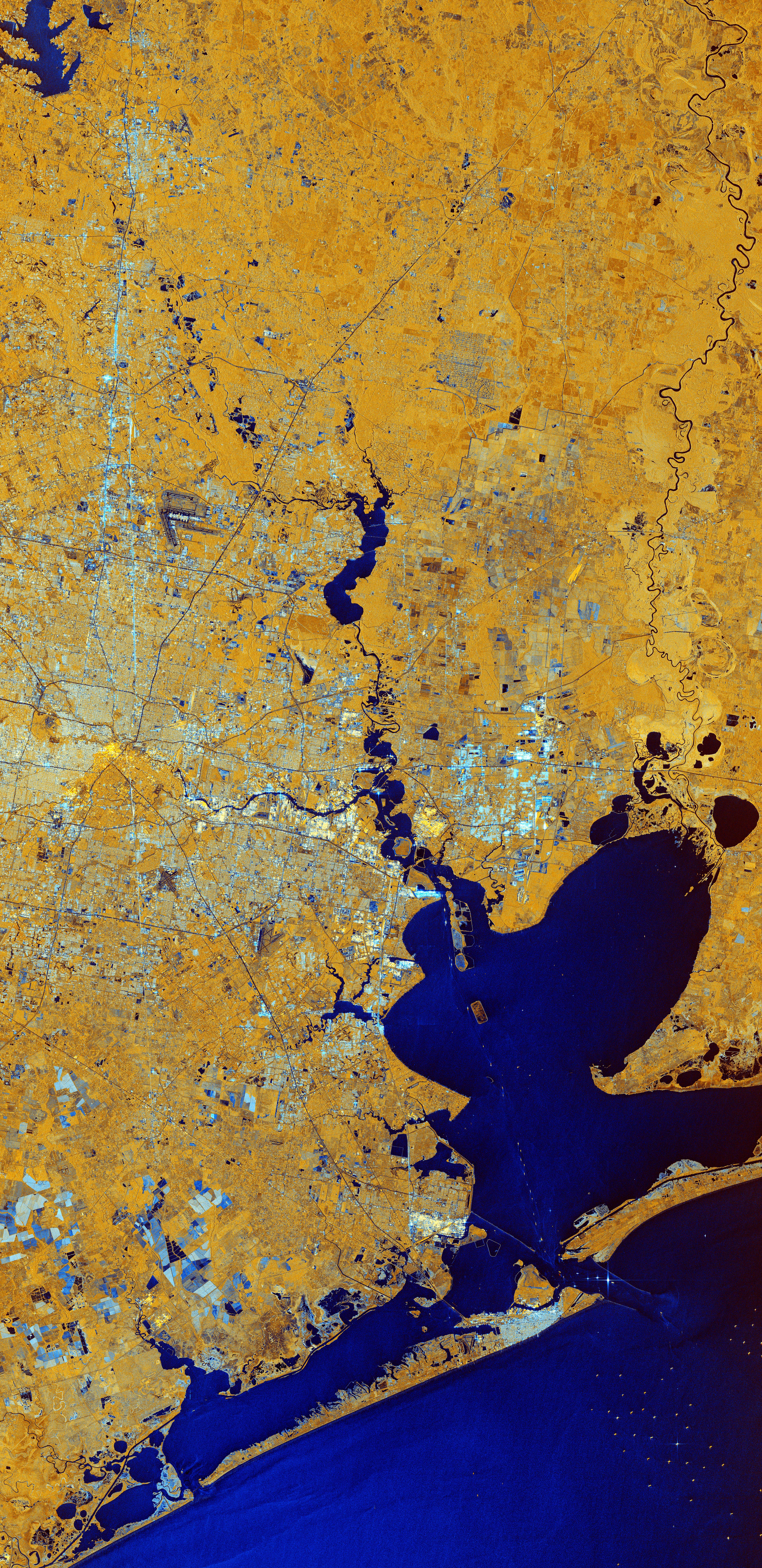
    (Click image for full view.) Houston, Texas, US, is featured in this composite image, captured on June 21, 2019, by the Copernicus Sentinel-1 mission. The city of Houston appears in shades of white and grey which contrasts with the yellow tones of the surrounding land and the dark blue waters of the Gulf of Mexico. Credit: Contains modified Copernicus Sentinel data (2019), processed by ESA, CC BY-SA 3.0 IGO

    Houston, Texas, US, is featured in this image captured by the Copernicus Sentinel-1 mission.

    The two identical Copernicus Sentinel-1 satellites carry radar instruments to image Earth’s surface. Images acquired with radar are interpreted by studying the intensity of the signal scattered back to the satellite – which is related to the roughness of the ground.

    The colors of this week’s image come from the combination of two polarisations from the Copernicus Sentinel-1 radar mission, which have been converted into a single RGB image. Interpreting polarisation can help scientists analyze the Earth’s surface.

    In this composite image, captured on June 21, 2019, the city of Houston appears in shades of white and grey which contrasts with the yellow tones of the surrounding land and the dark blue waters of the Gulf of Mexico.

    With a population of over two million and covering an area of over 1600 sq km (600 sq mi), Houston is the state’s most populous city and the fourth largest city in the US.

    Houston is dissected by a series of bayous passing. Buffalo Bayou can be seen cutting through Houston, before joining Galveston Bay visible at the bottom of the image. Galveston Bay is around 55 km (34 mi) long and around 30 km (19 mi) wide, making it the largest estuary in Texas. The shallow bay has an average depth of around 2 m (7 ft), which is unusually shallow for its size.

    The Port of Houston, which spreads across the northwest section of the bay, is one of the world’s largest ports, and many ships can be seen as multi-colored dots in the bottom-right of the image.

    Houston is home to the NASA Lyndon B. Johnson Space Center, which lies west of Galveston Bay. The center acts as NASA’s lead center for astronaut training as well as the International Space Station mission operations. It was identified as mission control or simply ‘Houston’ during the Apollo, Gemini, and Space Shuttle flights.

    The center also collaborates with other international facilities in a variety of scientific and engineering programs related to human space flight and planetary exploration. The Johnson Space Center is where many ESA astronauts are sent as part of their training and preparation for future space missions. This is where Luca Parmitano, who recently returned to Earth, trained for his Beyond mission to the International Space Station.

    Never miss a breakthrough: Join the SciTechDaily newsletter.
    Follow us on Google and Google News.

    European Space Agency Geography
    Share. Facebook Twitter Pinterest LinkedIn Email Reddit

    Related Articles

    Earth From Space: Magnificent Canadian Arctic Archipelago

    Breathtaking View of Andros, Bahamas From Space [Video]

    Earth From Space: Bolivian Highland Heart [Video]

    Flevoland, Netherlands From Space: One of the Largest Land Reclamation Projects in the World

    Earth From Space: Lake George, Uganda – A Center for Biological Diversity [Video]

    Deforestation in Bolivia Spied From Space Satellite

    Earth From Space: Japanese Archipelago [Video]

    Earth From Space: Faroe Islands [Video]

    Earth From Space: Tromsø, Norway [Video]

    Leave A Reply Cancel Reply

    • Facebook
    • Twitter
    • Pinterest
    • YouTube

    Don't Miss a Discovery

    Subscribe for the Latest in Science & Tech!

    Trending News

    These Toads Are Surviving a Deadly Fungus – Scientists May Finally Know Why

    These Brain Cells May Explain Why We Eventually Have To Sleep

    Tomatoes Contain an Invisible Ingredient With Surprising Effects on Liver Health

    World’s First Heat-Powered Cooling System Turns Waste Heat Into Cold

    Antarctica Gained a Record 695 Billion Tons of Ice in Just Two Years

    Don’t Miss: A Brilliant Venus and Glowing Harvest Moon Light Up the Sky

    New Twist on the Einstein Problem Reveals Unexpected Physics

    JWST Captures Stunning Evidence of How Supermassive Black Holes Feed

    Follow SciTechDaily
    • Facebook
    • Twitter
    • YouTube
    • Pinterest
    • Newsletter
    • RSS
    SciTech News
    • Biology News
    • Chemistry News
    • Earth News
    • Health News
    • Physics News
    • Science News
    • Space News
    • Technology News
    Recent Posts
    • Scientists Discover a Hidden Defect That Could Explain Why IBD Keeps Coming Back
    • Millions Take Blood Pressure Drugs, but Many May Be Missing Their Heart-Protective Benefits
    • Could Alien Life Be Conscious in Ways We Can’t Imagine?
    • Scientists Develop a Fruit Wash That Removes Pesticide Residues and Keeps Produce Fresh Longer
    • Scientists May Have Finally Explained Why Astronauts Get Constipated in Space
    Copyright © 1998 - 2026 SciTechDaily. All Rights Reserved.
    • Science News
    • About
    • Contact
    • Editorial Board
    • Privacy Policy
    • Terms of Use

    Type above and press Enter to search. Press Esc to cancel.