The Sentinel-6 Michael Freilich satellite is advancing sea-level monitoring with unmatched precision, , continuing a 30-year record and setting new standards in climate monitoring.
Sea-level rise is one of the most immediate consequences of climate change, as highlighted recently through urgent pleas from leaders of island nations at the COP26 summit. Global measures of sea-level rise are imperative to underpinning global policy and for strategies to protect coastlines and low-lying lands. Measuring tiny differences in the height of the sea surface from space is no easy task – but that’s exactly what the Copernicus Sentinel-6 Michael Freilich satellite is doing. And, after a year of exhaustive testing, this new mission is now delivering the world’s most accurate data on sea-level rise.
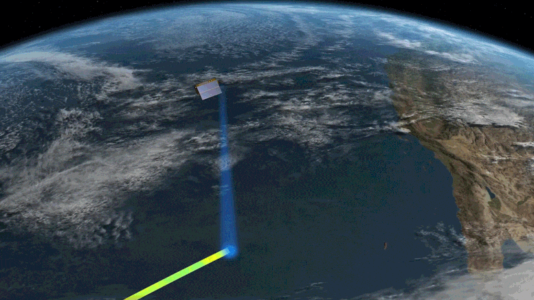
Launched on November 21, 2020, Copernicus Sentinel-6 Michael Freilich uses the latest radar altimetry technology, developed by ESA, to advance the long-term record of sea-surface height measurements that began in 1992 by the French–US Topex-Poseidon satellite and that were followed by the Jason series of satellite missions.
With the importance of monitoring sea-level rise so high on the global agenda, numerous organizations have been involved in making Copernicus Sentinel-6 the gold standard reference mission to take the record of sea-surface height measurements into the future, and to do this with greater precision than ever before.
So while Sentinel-6 is one of the European Union’s family of Copernicus missions, its implementation is the result of an exceptional cooperation between the European Commission ESA, Eumetsat, NASA, and NOAA, with support from the CNES French space agency.
Eumetsat – the European Organisation for the Exploitation of Meteorological Satellites, is responsible for operating the satellite and for making the data available to users.
The first data products, which were low-resolution products, were released in June. This was an important step in the transition to the higher-resolution products being released today. The data have been used for weather forecasting and seasonal forecasting models, and to forecast the development and track of hurricanes.
Sentinel-6’s Poseidon-4 altimeter was designed to bring new high-resolution Ku-band synthetic aperture radar measurements into the altimetry reference time series. It, therefore, delivers simultaneous low-resolution measurements and high-resolution measurements. The low-resolution measurements are matched with measurements from the mission’s predecessor, Jason-3, and, therefore, critical to ensuring continuity, and the enhanced high-resolution data can then be offered with absolute confidence.
To make sure that differences between the historical low-resolution time series and the new data from Copernicus Sentinel-6 Michael Freilich are fully understood, a 12-month tandem flight has been taking place. This involves Sentinel-6 flying 30 seconds behind its predecessor satellite, Jason-3, following the same ground track.
Following months of careful testing, the stream of Copernicus Sentinel-6 high-resolution data are now available.
Eumetsat’s ocean altimetry program manager, Julia Figa Saldana, said, “Experts from around the globe have closely examined and validated the data, confirming that the Copernicus Sentinel-6 mission is robust, precise, and highly reliable. By cross-calibrating Sentinel-6 against its predecessor Jason-3 to within 1 mm, we ensure that the 30-year record of mean sea level, as captured by satellite radar altimeters, continues uninterrupted.
“The data released today is critical for monitoring the impact of climate change on Earth’s oceans.”
ESA’s Sentinel-6 mission scientist, Craig Donlon, added, “Measurements of sea-level rise provide a unique but integrated view of climate change since a warming ocean expands and increased melting of ice on land both lead to an increase in sea level.
“Sentinel-6 Michael Freilich securely brings a new synthetic aperture radar measurement technique into the reference altimeter time series for the first time. This allows Sentinel-6 to provide improved sea state and wind speed measurements, enhanced capabilities for river and lake hydrology applications while maintaining the stability of sea-level rise estimates. These measurements provide evidence that is critical to develop and implement robust societal policy for our future.”
ESA’s Copernicus Sentinel-6 project manager, Pierrik Vuilleumier, noted, “The collaboration with NASA, EUMETSAT, NOAA and CNES has, today, come to fruition with the timely release of mission products to operational users, providing both continuity with previous reference missions and new high-resolution synthetic aperture radar products. The Poseidon-4 altimeter’s digital technology brings unprecedented level of performance.”
“While Sentinel-6 Michael Freilich is exceeding expectations in orbit, we are busy with its follow on, Sentinel-6B. The satellite is now at IABG’s facilities in Ottobrunn, Germany, undergoing an environmental test campaign that will run through until next March. In the middle of the year it will be put into storage until we prepare it for launch at the end of 2025.”
Never miss a breakthrough: Join the SciTechDaily newsletter.
Follow us on Google and Google News.
1 Comment
As measured by imaging satellites, most Pacific Islands are growing in area, rather than shrinking!
While they may be able to tease out 1 mm precision of altitude over calibration ground-stations, over the open oceans, they are ultimately dependent on relatively coarse gravity models. They must assume that the gravity field isn’t substantially modified by isostatic adjustment of the ocean basins as the volume of ocean water increases.
My suspicion is that the propagation of uncertainties through all the systems, which will be additive, will be at least an order of magnitude greater than the 1 mm cited. Even at 1 mm, that amounts to about 1/2 to 1/3 of the estimated annual average global rise in sea level. Would you be satisfied if the manufacturer of your car informed you that you could expect gas mileage of 30 MPG +/-15 MPG?
Note that the technical specifications for the Sentinel-6 system have every page marked with the following: “Proprietary information: no part of this document may be reproduced divulged or used in any form without prior permission from CLS.” So much for open, transparent communication.
https://www.eumetsat.int/media/38625