
NASA and France’s SWOT satellite has captured rare, detailed measurements of a tsunami generated by a powerful 8.8 magnitude earthquake near Russia’s Kamchatka Peninsula.
This data, including wave height, shape, and direction, is helping NOAA fine-tune its tsunami forecast models, which are crucial for early warnings to coastal communities. Even seemingly small waves in the open ocean can become towering threats near shore, and SWOT’s real-world observations allow scientists to better match forecasts to reality, potentially revolutionizing tsunami prediction capabilities worldwide.
SWOT Satellite Captures Rare Kamchatka Tsunami
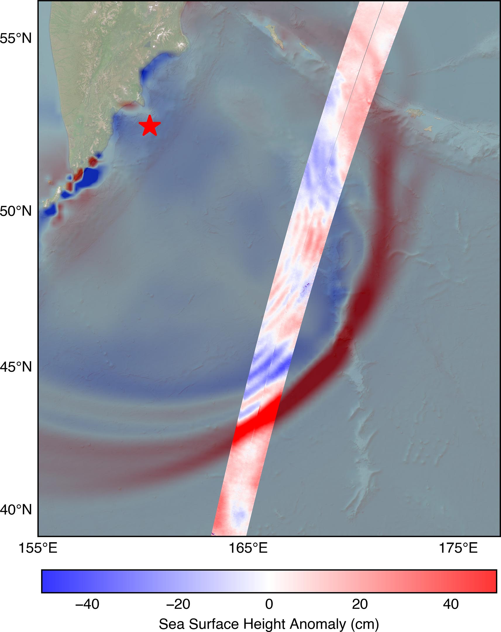
On July 30 at 11:25 a.m. local time, the SWOT (Surface Water and Ocean Topography) satellite recorded a tsunami generated by an 8.8 magnitude earthquake off Russia’s Kamchatka Peninsula. Developed through a partnership between NASA and the French space agency CNES (Centre National d’Études Spatiales), the satellite captured the event roughly 70 minutes after the quake occurred.
Tsunamis form when powerful disturbances, such as major earthquakes or underwater landslides, force an entire column of seawater to move from the ocean floor to the surface. This sudden shift produces waves that spread outward from the source, much like ripples radiating across a pond after a stone is dropped in.
A New Era in Ocean Observation
“The power of SWOT’s broad, paintbrush-like strokes over the ocean is in providing crucial real-world validation, unlocking new physics, and marking a leap towards more accurate early warnings and safer futures,” said Nadya Vinogradova Shiffer, NASA Earth lead and SWOT program scientist at NASA Headquarters in Washington.
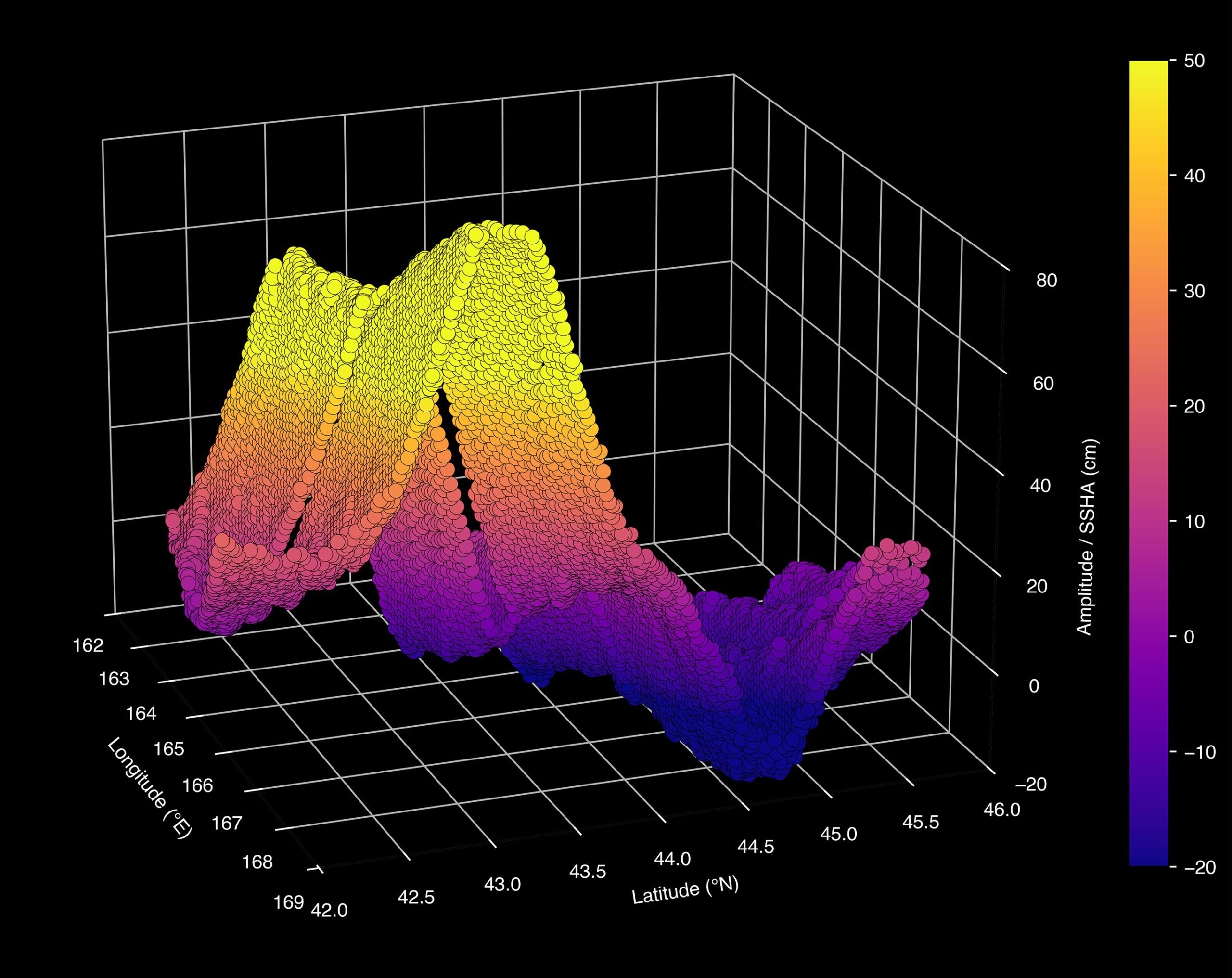
Using its advanced instruments, SWOT delivered a detailed, multidimensional view of the tsunami’s leading edge. The satellite measured a wave height of more than 1.5 feet (45 centimeters), indicated in red on the visual track, and captured its shape and movement direction. This swath of data, stretching from the southwest to the northeast, was compared to a forecast model from the U.S. National Oceanic and Atmospheric Administration (NOAA) Center for Tsunami Research. The comparison allowed scientists to confirm the model’s accuracy and strengthen its reliability for future forecasts.
Why Small Waves at Sea Can Become Giants on Shore
“A 1.5-foot-tall wave might not seem like much, but tsunamis are waves that extend from the seafloor to the ocean’s surface,” said Ben Hamlington, an oceanographer at NASA’s Jet Propulsion Laboratory in Southern California. “What might only be a foot or two in the open ocean can become a 30-foot wave in shallower water at the coast.”
The tsunami measurements SWOT collected are helping scientists at NOAA’s Center for Tsunami Research improve their tsunami forecast model. Based on outputs from that model, NOAA sends out alerts to coastal communities potentially in the path of a tsunami. The model uses a set of earthquake-tsunami scenarios based on past observations as well as real-time observations from sensors in the ocean.
Reverse Engineering Tsunamis for Accuracy
The SWOT data on the height, shape, and direction of the tsunami wave is key to improving these types of forecast models. “The satellite observations help researchers to better reverse engineer the cause of a tsunami, and in this case, they also showed us that NOAA’s tsunami forecast was right on the money,” said Josh Willis, a JPL oceanographer.
The NOAA Center for Tsunami Research tested their model with SWOT’s tsunami data, and the results were exciting, said Vasily Titov, the center’s chief scientist in Seattle. “It suggests SWOT data could significantly enhance operational tsunami forecasts — a capability sought since the 2004 Sumatra event.” The tsunami generated by that devastating quake killed thousands of people and caused widespread damage in Indonesia.
More About SWOT
The Surface Water and Ocean Topography (SWOT) satellite is a joint mission developed by NASA and CNES (French space agency), with key contributions from the Canadian Space Agency (CSA) and the UK Space Agency. NASA’s Jet Propulsion Laboratory (managed by Caltech in Pasadena, California) leads the U.S. portion of the project, supplying critical instruments including the Ka-band Radar Interferometer (KaRIn), a GPS science receiver, a laser retroreflector, a two-beam microwave radiometer, and instrument operations.
CNES contributed the Doppler Orbitography and Radioposition Integrated by Satellite (DORIS) system, the dual-frequency Poseidon altimeter (built by Thales Alenia Space), the KaRIn radio-frequency subsystem (with Thales Alenia Space and UK Space Agency support), as well as the satellite platform and ground operations. The KaRIn high-power transmitter assembly was provided by CSA. Together, these components enable SWOT to measure the height and movement of water surfaces across Earth’s oceans, lakes, and rivers with unprecedented detail.
Never miss a breakthrough: Join the SciTechDaily newsletter.
Follow us on Google and Google News.
12 Comments
You think that. But tsunamis have killed thousands of people. And it was a thirty foot wave because it was from ground up. Not on the surface like normal waves. Aloha
I thought that at first as well. Then I read the article. 1.5 feet waves are not normal in the middle of the ocean. When one is detected, they know that is the beginning of a huge tsunami on its way. This is a huge advancement in saving people’s lives.
It always helps to read the article.
I didn’t need to read but a handful of sentences to get the gist of the article. It’s not Shakespeare. You just gotta read it for more than five seconds. I would absorb three, maybe four paragraphs, as a rule of thumb. Before I ventured an opinion. Just so people don’t think I’m, well you know. Not me, but some folks might ! Say, something.
We can get all the information. But people need to be proactive and educate themselves. Watch for what’s coming there way not wait until the last minute and alot of people do that. Sad but true.
When are you dumb American reporters ever get it right its a SNOT SATELLITE NOT A SWOT SATELLITE, Les dingbats
Surface Water and Ocean Topography = SWOT. You are seriously calling people “dumb” when you can’t read a simple acronym? But I suppose you know more than NASA, JPL, and CNES.
Le sot…
If that data is correct (not!), we would be losing our beauty sleep over every buoy’s dance across the Pacific Ocean. Only at the USGS was such an event as reported – nowhere else. Yearly, rogue waves, higher than 25 meters, unluckily ride our seas every so often, without the fake-news. I think it’s about time that some peer reviews cross periodicals pages to clear out the hook, line-and-sinker trash piling to clear publication dates.
A 25 meter rogue wave at sea will likely have only very local effect. A tsunami, perhaps only 1.5 in height, may travel thousands of miles, growing to catastrophic amplitude as it approaches shore. That’s not “fake news”, that’s reality.
does a tsunami go Florida
Don’t worry, tsunamis are banned in Florida.
You should be more gruntled. The image doesn’t represent the 1.5 foot wave at sea. It represents the resulting killer wave approaching the shore.