
Close Menu
    Facebook X (Twitter) Instagram
    SciTechDaily
    • Biology
    • Chemistry
    • Earth
    • Health
    • Physics
    • Science
    • Space
    • Technology
    Facebook X (Twitter) Pinterest YouTube RSS
    SciTechDaily
    Home»Earth»South African Town Covered in Mining Waste After Dam Collapse
    Earth

    South African Town Covered in Mining Waste After Dam Collapse

    By Kathryn Hansen, NASA Earth ObservatoryOctober 23, 2022No Comments3 Mins Read
    Facebook Twitter Pinterest Telegram LinkedIn WhatsApp Email Reddit
    Share
    Facebook Twitter LinkedIn Pinterest Telegram Email Reddit
    Jagersfontein Mining Waste Dam Collapse
    A dam collapse at a diamond mine in Jagersfontein, South Africa, on September 11, 2022, released sludge that poured across the landscape, destroying homes, inundating rivers and grazing land, and injuring dozens.

    Nearly one month after the collapse of a tailings dam, the South African mining town Jagersfontein and nearby water systems remained capped with muddy debris.

    On September 11, 2022, at a diamond mine in Jagersfontein, South Africa, a dam collapsed, releasing a watery mixture of mining waste known as tailings. The sludge streamed across the landscape, inundating rivers and grazing land, destroying homes, and injuring dozens.
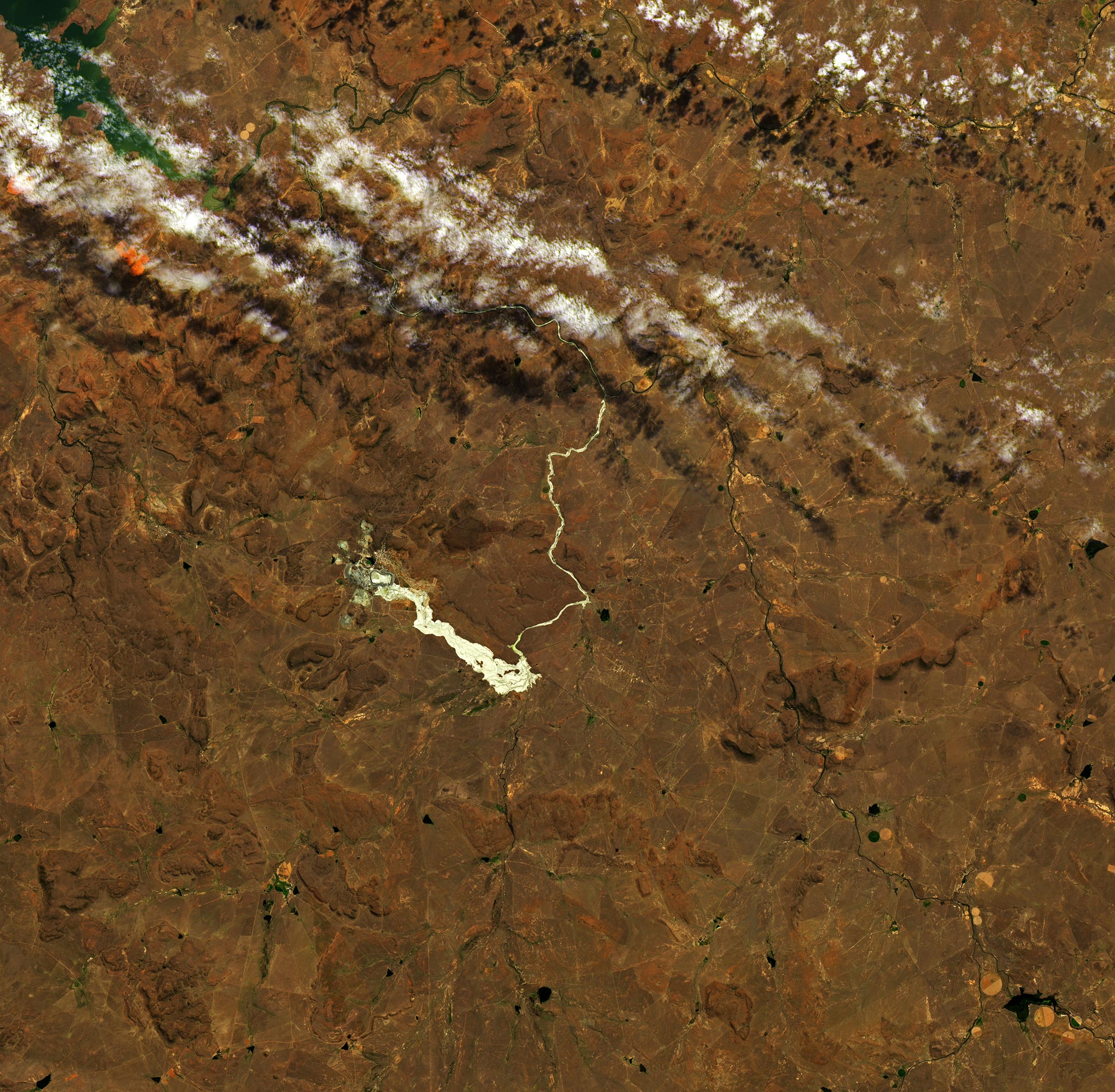
    Jagersfontein South Africa October 2022 Annotated
    October 4, 2022 – After the dam collapsed at Jagersfontein.

    Almost one month after the incident, satellite images reveal that the landscape remains altered by the coating of sludge. This can be seen in the image above, which was captured on October 4, 2022, by the Operational Land Imager-2 (OLI-2) on Landsat 9. For comparison, the other image (below) was acquired by the Operational Land Imager (OLI) on Landsat 8 on September 10, the day before the dam collapse.
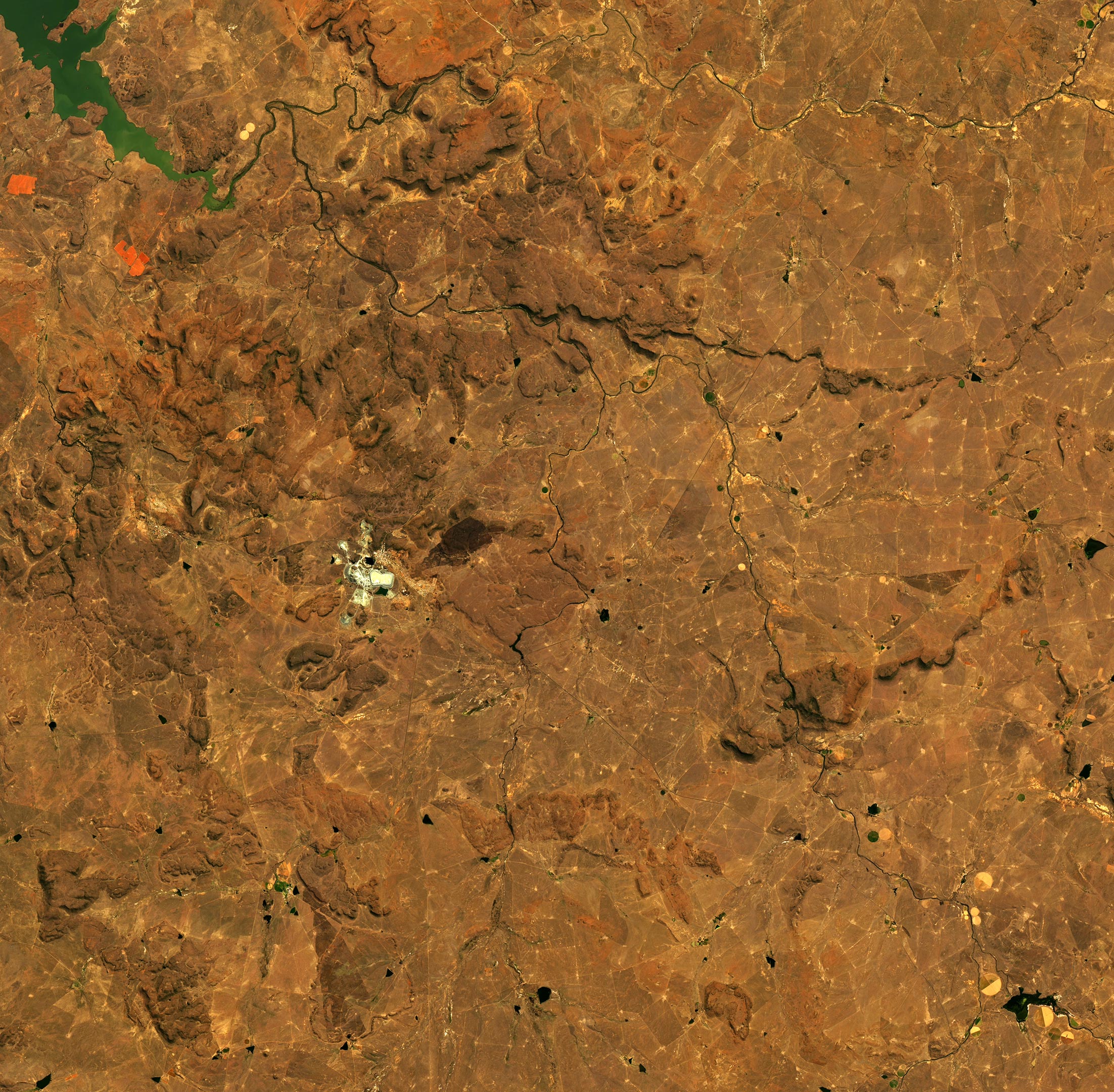
    Jagersfontein South Africa September 2022 Annotated
    September 10, 2022 – Before the dam collapsed at Jagersfontein.

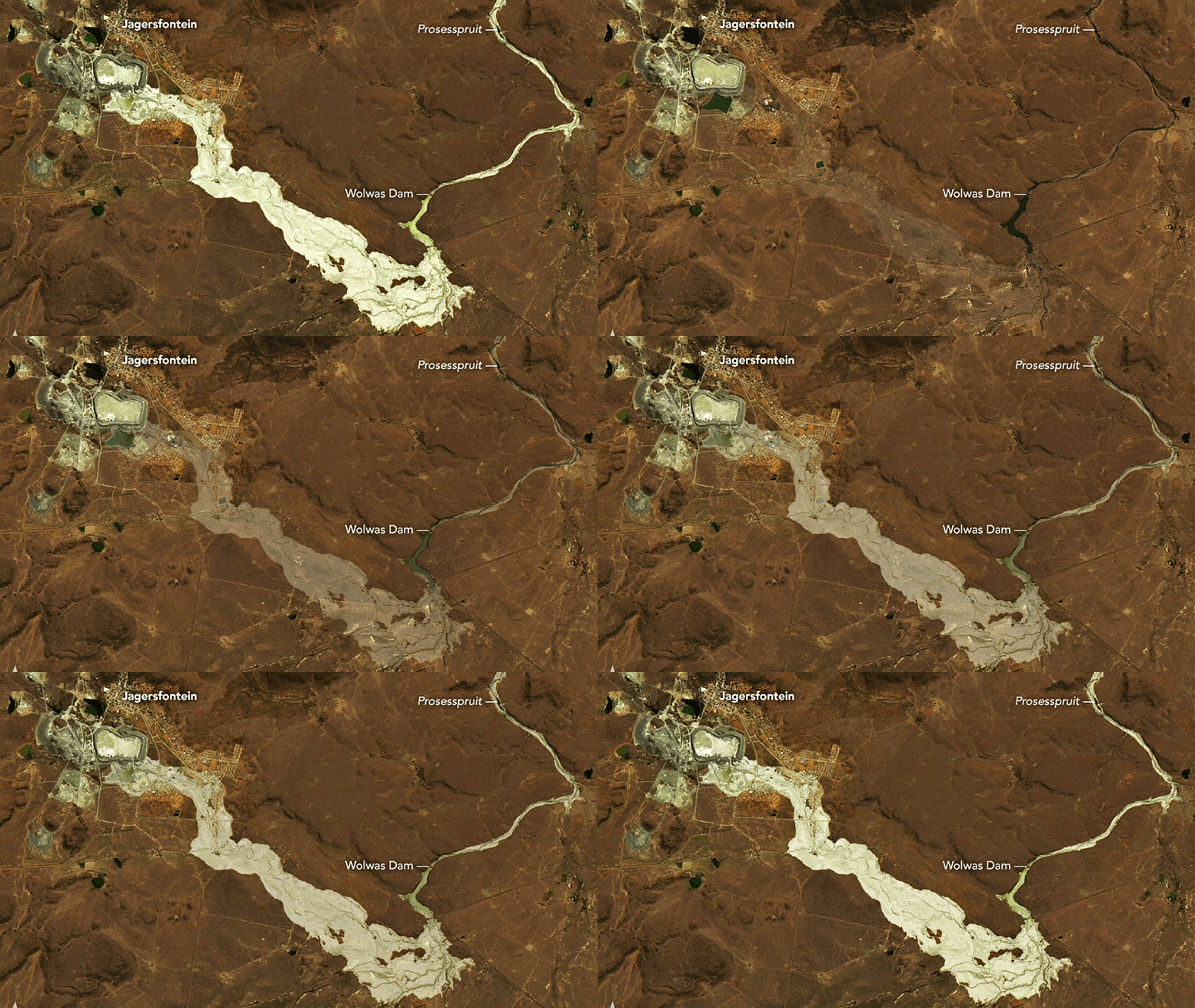
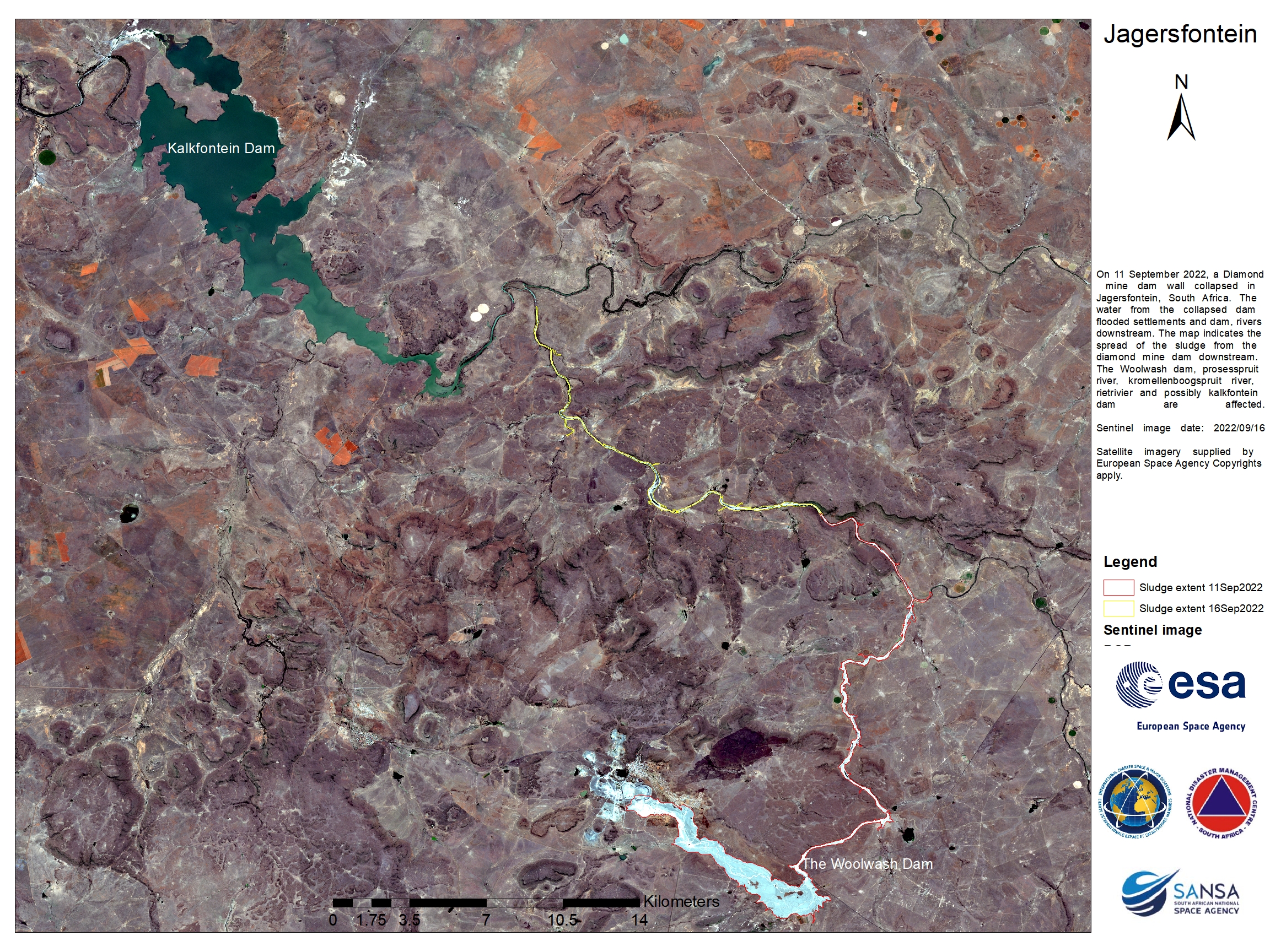
    The breach in the dam is visible on its southern side, through which most of the tailings poured out. Analysis of satellite images by geologist Dave Petley indicated that the plume reached up to 1 mile (1.5 kilometers) wide and extended about 5.3 miles (8.5 kilometers) toward the southeast. The sludge then turned north and entered several streams and rivers, including the Prosesspruit, and continued to at least Kalkfontein Dam (north of this image). It reached water systems used for drinking water and for agriculture.
    As the water receded, it left behind white and tan deposits. The lightest areas in this image are likely dried tailings and mud. Notice that the banks of the Prosesspruit appear wider after being eroded and damaged by the flood.

    According to news reports, the flood destroyed more than 160 homes, killed at least one person and hundreds of animals, and damaged more than 10 square miles (26 square kilometers) of grazing land. It remains to be seen how long the muck will persist. As the material dries out and hardens it could begin to blow away with the wind or be washed away by rain.

    NASA Earth Observatory images by Lauren Dauphin, using Landsat data from the U.S. Geological Survey.

    Never miss a breakthrough: Join the SciTechDaily newsletter.
    Follow us on Google and Google News.

    Geography NASA NASA Earth Observatory
    Share. Facebook Twitter Pinterest LinkedIn Email Reddit

    Related Articles

    NASA Picturing Earth: Astronaut Photography In Focus [Video]

    Coloring the Great Salt Lake – Astronaut Takes Beautiful Photograph From Space Station

    Sea Ice in Denmark Strait – Drifted More Than 1,000 Km (600 Miles) From the Arctic Ocean

    NASA Scientists Map Beirut Blast Damage – Devastating Explosion Rocked Port Area

    NASA Advanced Rapid Imaging Satellite Maps Blast Damage: Beirut Explosion Aftermath

    NASA/NOAA Satellites Observe Surprisingly Rapid Increase in Scale and Intensity of Fires in Siberia

    Mars Terraforming: Cultivating Ideas for Mars on Earth

    Meandering Mississippi River: Photo Taken by Astronaut on Space Station Shows Divergence From State Boundaries

    Incredible Rare Peek at Patagonia in Winter

    Leave A Reply Cancel Reply

    • Facebook
    • Twitter
    • Pinterest
    • YouTube

    Don't Miss a Discovery

    Subscribe for the Latest in Science & Tech!

    Trending News

    Giant Plasma Waves May Be Stripping Away Mars’ Atmosphere

    Scientists Thought SuperAgers Had Lucky Genes. They Were Wrong

    Astronomers Find Ancient Black Holes Shining With the Power of a Trillion Suns

    Researchers Solve Mystery Behind Contradictory Weight-Loss Drug Paradox

    Long-Lost Megalodon Fossils Found Hiding on a Museum Shelf

    Experimental Eye Drops Restore Sight in Blind Mice

    Scientists Discover the Brain May Enter a New Biological Phase Between 50 and 75

    New Research Reveals Autistic Brains Process Faces Differently

    Follow SciTechDaily
    • Facebook
    • Twitter
    • YouTube
    • Pinterest
    • Newsletter
    • RSS
    SciTech News
    • Biology News
    • Chemistry News
    • Earth News
    • Health News
    • Physics News
    • Science News
    • Space News
    • Technology News
    Recent Posts
    • Lost in Space: Rare Cosmic Flare Exposes a Wandering Black Hole Far From Its Galaxy’s Center
    • Dark Matter May Be Leaving a Signal in Earth’s Atmosphere
    • Scientists Find Remarkable New Snail Species in Montenegro’s Mountains
    • Scientists Discover a 300-Million-Year-Old Geological Time Capsule Inside Fossilized Wood
    • Why Are Wasps Disappearing This Summer?
    Copyright © 1998 - 2026 SciTechDaily. All Rights Reserved.
    • Science News
    • About
    • Contact
    • Editorial Board
    • Privacy Policy
    • Terms of Use

    Type above and press Enter to search. Press Esc to cancel.