Arctic sea ice is subject to some serious travel restrictions. Penned in by major land masses, most ice that forms in the Arctic Ocean stays there for the duration of its existence—typically one to four years before melting. Some ice, however, escapes the Arctic Ocean through a handful of passages and then drifts south.
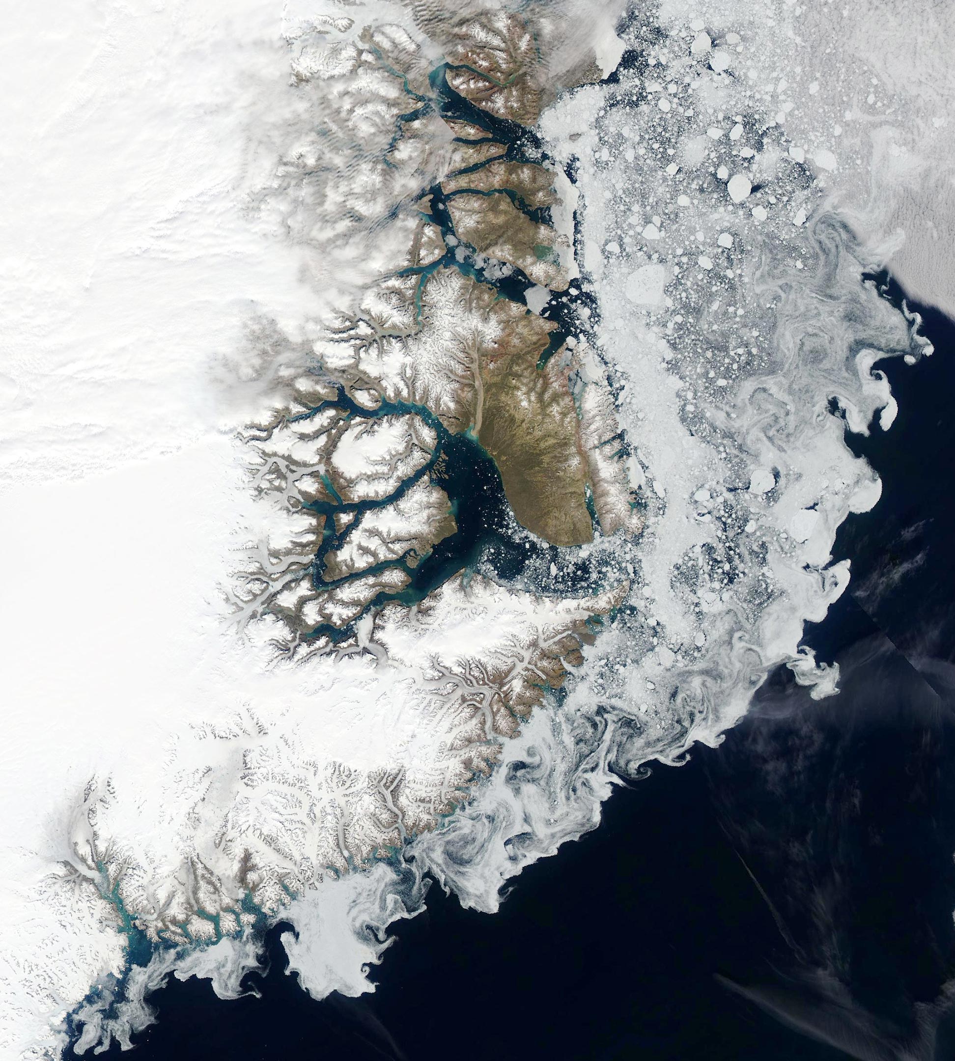
That’s the origin of the sea ice pictured here. When satellites acquired these images in July 2020, the ice had drifted more than 1,000 kilometers (600 miles) from the Arctic Ocean. The wide view above, acquired on July 2 with the Moderate Resolution Imaging Spectroradiometer (MODIS) on NASA’s Aqua satellite, shows sea ice hugging the coast of East Greenland. The detailed image below, acquired July 3 with the Operational Land Imager (OLI) on Landsat 8, shows ice south of the Scoresby Sound (Kangertittivaq) fjord system along the Denmark Strait.

“The pack-ice you see in the image is remnant ice that exited the Arctic through Fram Strait,” wrote Robert Pickart, a high-latitude oceanographer at Woods Hole Oceanographic Institution. “It is in the process of melting out as it is carried southward by the East Greenland Current.”
The Fram Strait is the primary route for sea ice exiting the Arctic Ocean. This 450-kilometer (280-mile) wide passage between Greenland and Svalbard connects the Arctic Ocean with the Greenland Sea. The East Greenland Current originates north of the Fram Strait and moves seawater, along with some sea ice, southward toward the southern tip of Greenland.
Pickart, who was sailing on the R/V Armstrong near the southern tip of Greenland at the time of this interview, noted that the current is unstable and tends to meander. The instability causes vortices of water, or “eddies,” to propagate offshore, which can deform the seaward edge of the sea ice.
“This is a graphic example of how fresh water—both liquid and frozen—originating from the Arctic gets transferred to the interior of the Nordic seas, which modulates the wintertime transformation of the interior water,” Pickart said. “If this changes in the future, it has implications for the global overturning circulation that helps regulate our climate.”
NASA Earth Observatory images by Lauren Dauphin, using Landsat data from the U.S. Geological Survey and MODIS data from NASA EOSDIS/LANCE and GIBS/Worldview.
Never miss a breakthrough: Join the SciTechDaily newsletter.
Follow us on Google and Google News.
1 Comment
From a Risk management Perspective , shipping companies need to look out for such icebergs and detect and avoid a future Titanic like collision and consequential Disaster. The likelihood of the same will continue to increase rapidly as as Climate Change and Temperature Rise increass inexorably and many more chunks of Icebergs from the Artic Sea break away and float into major shipping lanes. Thank God for modern technology and Sateelite Technology. The Problem with Icebergs is most of it is not visible and underwater. Not sure , whether satellites can determine the size and how much of the Iceberg is not visible and could cause damage..
The US President was not unwise in making an offer to buy Greenland from the danes. People may think he is stupid and does not know what he is doing. However, one does not become a billionaire without being crafty as a Fox. My personal opinion.