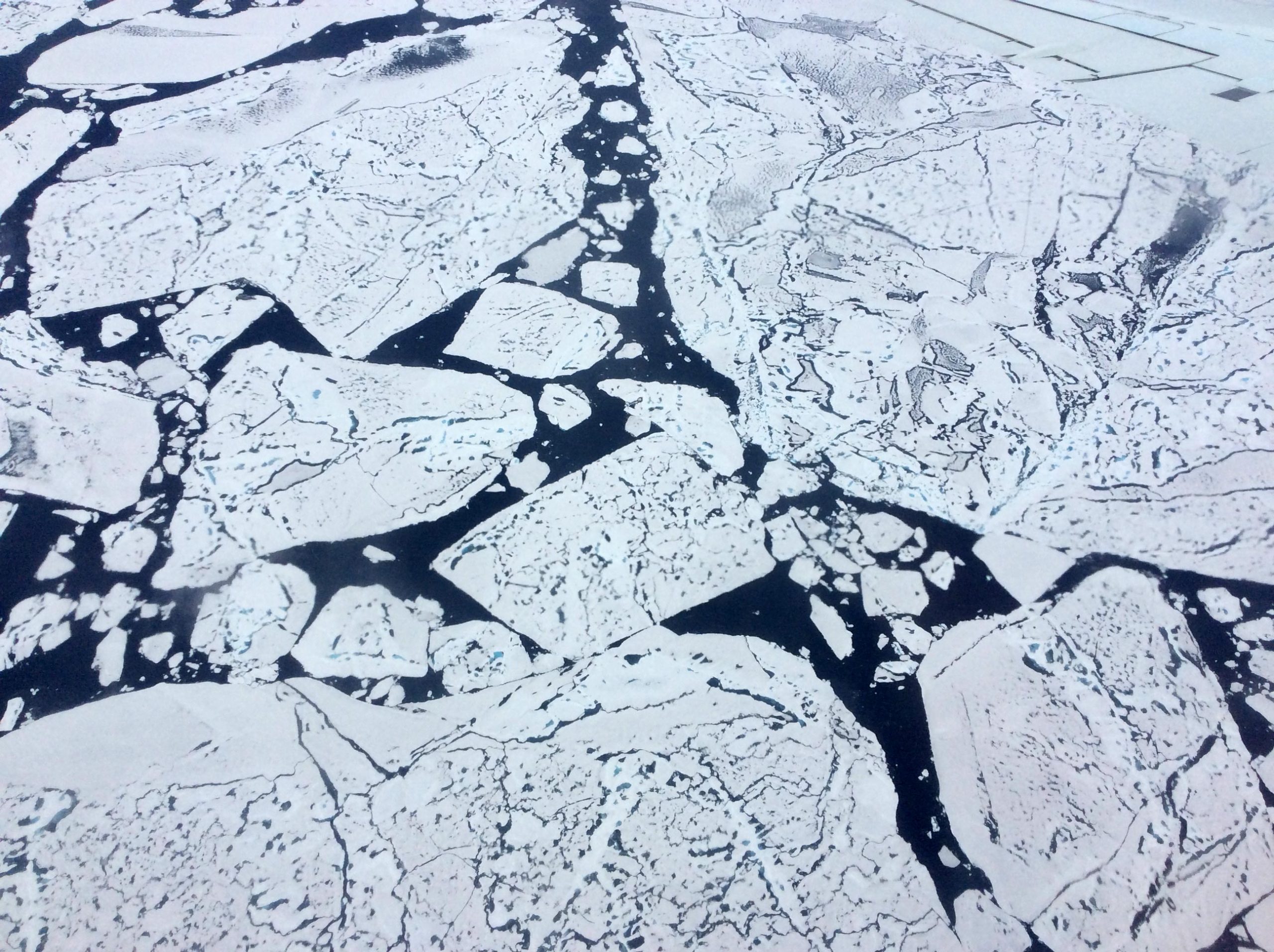
One method that scientists use to monitor climate change is the measurement of sea ice extent. Arctic sea ice extent, quite simply, is the area of ice that covers the Arctic Ocean at a given time. Sea ice plays a significant role in reflecting sunlight back into space, regulating ocean and air temperature, circulating ocean water, and preserving animal habitats.
NASA and the National Snow and Ice Data Center in Boulder, Colorado, use satellites to observe sea ice extent. Over the past several decades, Arctic sea ice extent has been steeply declining year-round, especially in late summer when it reaches its minimum for the year. Sea ice forms in the cold winter months, when seawater freezes into massive blocks of floating ice, then partially melts away in the warm summer months. This is a cycle that repeats every year.
Here are five facts to help you better understand Arctic sea ice.
1. Sea Ice Extent is Declining
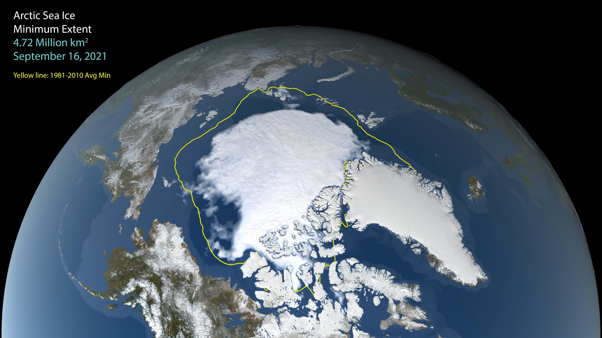
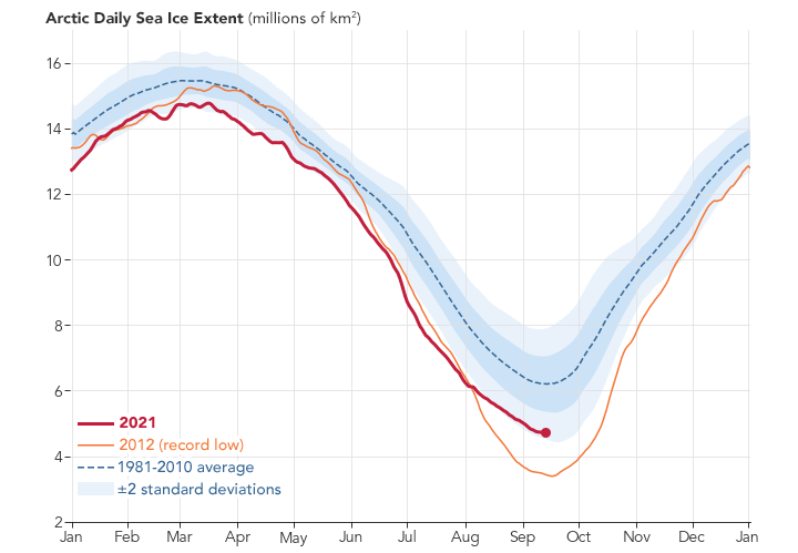
NASA has tracked sea ice minimum (usually in September) and maximum (usually in March) extents since 1978. While the exact extent figures may vary year to year, the overall trend is clear: the Arctic is losing sea ice year-round.
“The last 15 years, we’ve seen the lowest 15 sea ice minimum extents,” said Dr. Rachel Tilling, a sea ice scientist at the University of Maryland and NASA’s Goddard Space Flight Center in Greenbelt, Maryland. “Each year we’re losing an area that’s roughly the size of West Virginia.”
Arctic sea ice minimum extent is now declining at a rate of 13.1% per decade. The pace is likely to accelerate because of climate change-induced warming and the ice-albedo feedback cycle. The albedo effect describes the white ice surface’s ability to reflect Earth-bound sunlight back to space. Redirecting solar energy away from the ocean keeps the seawater beneath the ice cooler. When sea ice melts, darker-colored liquid water is left exposed to absorb sunlight. That warmer water then melts additional ice, creating the ice-albedo feedback cycle.
2. Sea Ice Helps Prevent Atmospheric Warming
Sea ice acts as a “blanket,” separating the ocean from the atmosphere, according to Tilling. In addition to keeping sunlight out, sea ice traps existing heat in the ocean, keeping it from warming the air above.
“The ability of the ice to keep heat in the ocean depends not only on its extent, but also on its thickness,” Tilling said.
Every year, some ice survives the summer melt. Once winter hits, more water freezes and it becomes thicker and stronger “multiyear ice.” First-year ice is thinner and more likely to melt, fracture, or even be swept out of the Arctic. With more ice melting every year, there is less recuring, multi-year ice. As a result, Arctic sea ice is as young and thin as it has ever been, making it a less efficient blanket.
Working from a combination of satellite records and declassified submarine sonar data, NASA scientists have constructed a 60-year record of Arctic sea ice thickness. Right now, Arctic sea ice is the youngest and thinnest its been since we started keeping records. More than 70 percent of Arctic sea ice is now seasonal, which means it grows in the winter and melts in the summer, but doesn’t last from year to year. This seasonal ice melts faster and breaks up easier, making it much more susceptible to wind and atmospheric conditions. Credit: NASA/Katy Mersmann
3. Sea Ice Affects Arctic Wildlife Above and Below Water
“There’s a huge ecosystem that’s impacted by changes to sea ice,” Tilling said. As sea ice declines, animals such as Arctic Foxes, polar bears and seals lose their habitat.
There are effects beneath the ice’s surface, too.
As ice crystals form atop seawater, they leave behind salt in the ocean below. This dense, salty water can sink to the bottom of the ocean. The descending water in one location will be offset by rising motion in others, which results in more nutrient-dense water circulating up toward the surface. Those nutrients are essential to microscopic phytoplankton, which are then eaten by fish and animals. The regular melt-freeze cycle keeps underwater Arctic life thriving, from algae to killer whales.
4. Sea Ice Melt Does Not Greatly Contribute to Sea Level Rise
Because sea ice forms from the seawater it floats on, it behaves much like an ice cube in a glass of water. Like that ice cube, which does not change the water level of the glass when it melts, melting sea ice in the Arctic does not dramatically change sea level. Melting land ice, for example from the Greenland or Antarctic ice sheets, does contribute to sea level rise. That’s because when land ice melts, it releases water that was previously trapped on land and adds to the water in the oceans.
NASA’s Ice, Cloud, and land Elevation Satellite-2 (ICESat-2) will provide scientists with height measurements that create a global portrait of Earth’s third dimension, gathering data that can precisely track changes of terrain including glaciers, sea ice, and forests. Credit: NASA/Ryan Fitzgibbons
5. Satellites Allow NASA to Monitor Sea Ice
The Arctic Ocean is a difficult place to access and study. That’s why NASA, the National Oceanic and Atmospheric Administration (NOAA), the European Space Agency, and others, turn to the vantage point of space to gather observations from the region. Two types of instruments are generally used to monitor sea ice, Tilling said.
The first type is passive microwave instruments, which track extent over time. A series of these instruments aboard satellites supported by NASA, NOAA, the U.S. Department of Defense, and international partners, have monitored arctic sea ice extent since 1978 – more than 40 years.
“Passive microwave instruments measure the microwave emission of surfaces,” Tilling said. The microwave emissions occur naturally, and the signature of sea ice is different from that of water, allowing scientists to precisely locate both from year to year.
The second type is altimetry instruments, which can be used to estimate sea ice thickness. NASA’s Ice, Cloud, and land Elevation Satellite-2 (ICESat-2), launched in 2018, uses a laser to measure the height of the ice and the height of the water. Using the known relationships between the two measurements (what height of ice above the water’s surface corresponds to the depth of the ice below it), scientists can calculate its total thickness.
Researchers continue to study the Arctic to learn more about the local and global consequences of diminishing sea ice.
“Our planet is this huge, interconnected place, and the atmosphere is connected across it,” Tilling says. “The Arctic is changing so rapidly, that we don’t even know yet exactly how the changes there are going to impact us. All we know is that they will.”
Never miss a breakthrough: Join the SciTechDaily newsletter.
Follow us on Google and Google News.
4 Comments
“The albedo effect describes the white ice surface’s ability to reflect Earth-bound sunlight back to space. Redirecting solar energy away from the ocean keeps the seawater beneath the ice cooler. When sea ice melts, darker-colored liquid water is left exposed to absorb sunlight.”
This is a common misconception stated by those who should know better. Snow is a diffuse reflector, thus it looks bright no matter where the viewer is with respect to the sun. However, water is a specular reflector, and one has to be positioned looking into the sun, at the same angle above the water as the sun, to see any light. The effect is not unlike driving on wet pavement at sunset. The pavement off one’s shoulder looks dark, whereas the light reflected off the pavement in front of the car is blinding! At glancing angles, the reflected light can reach 100%, much brighter than old snow! Therefore, this “albedo effect” overstates the net result of melting snow and ice.
Read the following for some real science:
https://wattsupwiththat.com/2016/09/12/why-albedo-is-the-wrong-measure-of-reflectivity-for-modeling-climate/
“The first type are passive microwave instruments, which track extent over time. A series of these instruments aboard satellites supported by NASA, NOAA, the U.S. Department of Defense, and international partners, have monitored arctic sea ice extent since 1978 – more than 40 years.”
I’m familiar with the instruments. I was involved with one of the first experimental NASA overflights near — what was then known as — Point Barrow (Alaska) in 1967, while I was in the Scientific and Engineering Personnel program in the US Army; I was stationed at the Cold Regions Research and Engineering Laboratory in Hanover, (NH).
Very interesting article.
Some thoughts for consideration.
1. White reflects sunlight. Black Absorbs Sunlight and warms the Ocean. Figure out what things other than Sea Ice will help reflect Solar Rays back into space.
2. Sea water is Salt water. It freezes at 28.4 degrees Faraneiht. Regular eater freezes at 32 degrees Faraneiht. So figure out ways to reduce Salt Content in the Ocean so it can result in more Ice formation in the Ses and Oceans. This will create a Virtuous cycle of Ice Formation which needs to be nurtured and reflects sunlight back into space.
3. The Sea of Galilee in the middle East (Israel) is extremely Salt Heavy. Understanding how it got that way, may give us some clues on other potential solutions.
4. Not certain, but I suspect that Salt in the Oceans and Seas may not be uniformly distributed, By locating water bodies in the Oceans and Seas with a greater propensity to freeze, and focusing efforts on Sea Ice formation in these areas, we may get better Ice formation in the Salt Water bodies Globally.
5. The higher up we go in the Atmosphere, the cooler it gets. So Ice formation is a natural tendency inbuilt into Nature. At near earth Space, temperatures are around 10 degrees Celsius. It may be easier to cool the same and encourage ice and snow formation of condensed water vapour on mountain tops from ten degrees Celsius to zero degrees Celsius and Ice formation on top of the mountains from current temperature on the mountain tops, to ensure the Ice mass on the Continental Shelf and Artic and Other Fresh water Sources are preserved for future Generations.
In management they teach us to not boil the Ocean.
No one ever said that we can’t take proactive actions to cool the Seas and Oceans and ensure Fresh Water Supplies (currently at three percent) is increased incrementally and becomes a controlled source of water requirements for drinking and Agriculture for all creatures and life forms including plankton deep in the seas and Oceans.
Rethinking Water Wars being predicted. 🙏🙏🙏
Views expressed are personal and not binding on anyone.
I too am a dreamer too residents of West Virginia. 😁😁😁
God bless🙏.
1. It is true that in some cases an object (diffuse reflector) appears black because it absorbs most of the light that hits it. However, in the case of specular reflectors, they look black for all but one special viewing direction, because all the light from the sun is reflected in a narrow sheaf that obeys the law that the angle of reflection equals the angle of incidence.
2. As NASA has discovered, there is no such thing as a free launch. It requires energy to do work. Removing salt will require prodigious amounts of energy! Where is that going to come from? If from fossil fuels, it will significantly increase CO2 production. If from nuclear fission, the CO2 footprint will be reduced, but the mining, smelting, fabrication, and construction of the facilities will contribute more CO2 for no other purpose than to reduce the salinity, which may not actually be all that helpful. Some questions: a) what do you do with the salt removed from the sea water, b) how do you dispose of the nuclear wastes, c) what happens to the local ecosystems when the salinity is suddenly reduced below the level that the organisms have evolved to exist in, d) what do you do if after spending all the money and building all the facilities it turns out that is isn’t effective because albedo isn’t as critical as claimed, as I suggest in my linked article?
3. Geologists know how the Sea of Galilee and the Dead Sea got that way. It is you who doesn’t know.
4. You are partially right about salinity varying. However, it is mostly evaporation in the tropics that increases surface salinity, and the influx of fresh river water that lowers the salinity elsewhere. Are you suggesting large, energy-consuming, underwater refrigerators to create ice off the mouth of the Amazon or Mekong rivers?
5. Orographic uplift is what is largely responsible for rain and snow in the mountains. What you are suggesting already happens naturally. To augment the process, will again, require prodigious amounts of energy. I’m left with the impression that you haven’t really thought these suggestions through thoroughly!!!