A warming climate is taking its toll on Greenland and Antarctica glaciers, melting them from above and below the surface. The more they melt, the higher sea levels rise.
When an ice cube is exposed to a heat source, like warm water or air, it melts. So, it’s no surprise that a warming climate is causing our glaciers and ice sheets to melt. However, predicting just how much the glaciers and ice sheets will melt and how quickly – key components of sea level rise – is not nearly as straightforward.
Glaciers and ice sheets are far more complex structures than ice cubes. They form when snow accumulates and is compressed into ice by new snow over many years. As they grow, they begin to move slowly under the pressure of their own weight, dragging smaller rocks and debris across the land with them. Glacial ice that extends to cover large landmasses, as it does in Antarctica and Greenland, is considered an ice sheet.
Greenland and Antarctica are home to most of the world’s glacial ice – including its only two ice sheets – making them areas of particular interest to scientists. Combined, the two regions also contain enough ice, that if it were to melt all at once, would raise sea levels by nearly 215 feet (65 meters) – making the study and understanding of them not just interesting, but crucial to our near-term adaptability and our long term survival in a changing world. Credit: NASA
The processes that cause glaciers and ice sheets to lose mass are also more complex. An ice cube’s surface melts when it’s exposed to ambient (warm) air. And while warm air certainly melts the surface of glaciers and ice sheets, they’re also significantly affected by other factors including the ocean water that surrounds them, the terrain (both land and ocean) over which they move, and even their own meltwater.
Greenland and Antarctica are home to most of the world’s glacial ice, including its only two ice sheets. These thick slabs of ice – some 10,000 feet (3,000 meters) and 15,000 feet (4,500 meters) thick, respectively – contain most of the freshwater stored on Earth, making them of particular interest to scientists. Combined, the two regions also contain enough ice that, if it were to melt all at once, would raise sea levels by nearly 215 feet (65 meters) – making the study and understanding of them not just interesting, but crucial to our near-term adaptability and our long-term survival in a changing world.
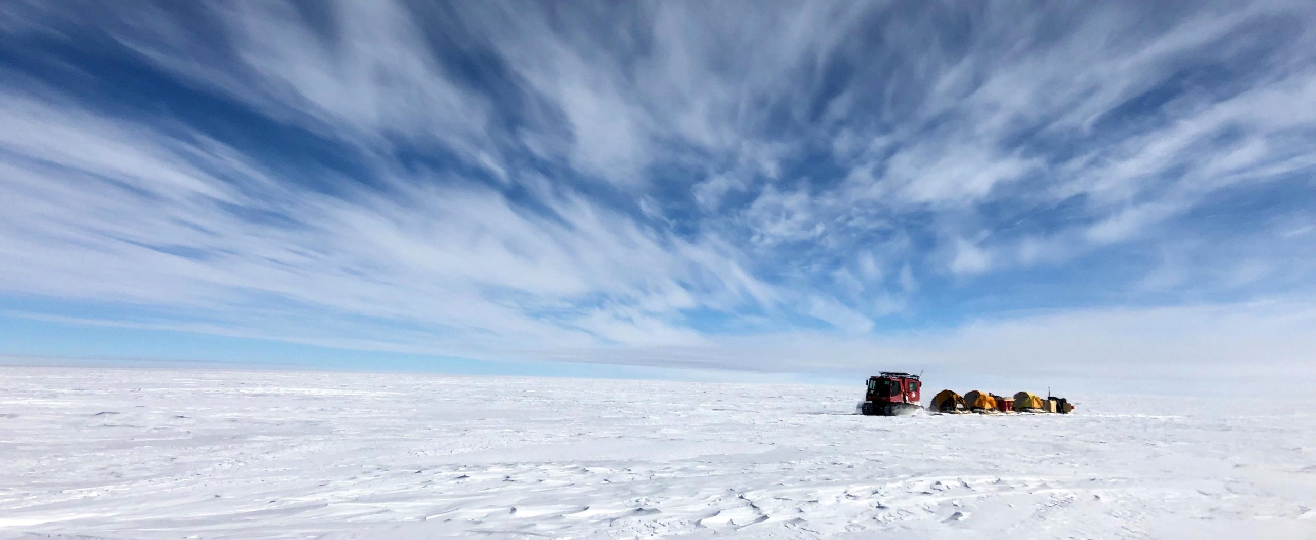
Ice Loss in Greenland
A glacier is considered “in balance” when the amount of snow that falls and accumulates at its surface (the accumulation zone) is equal to the amount of ice lost through melting, evaporation, calving, and other processes.
But with annual air temperatures in the Arctic increasing faster than anywhere else in the world, that balance is no longer achievable in Greenland. Warmer ocean waters surrounding the island’s tidewater glaciers are also problematic.
“It’s basically like pointing a hairdryer at an ice cube, while the ice cube is also sitting in a warm pot of water,” said Josh Willis, principal investigator of NASA’s Oceans Melting Greenland (OMG), a project that is investigating the effects of ocean water temperature on melting ice in the region. “The glaciers are being melted by heat from above and below simultaneously.”
Although the warm air and the warm water contribute to melting individually, the interplay between the meltwater from the glacier and the warm ocean water also plays a significant role.
When warm summer air melts the surface of a glacier, the meltwater bores holes down through the ice. It makes its way all the way down to the bottom of the glacier where it runs between the ice and the glacier bed, and eventually shoots out in a plume at the glacier base and into the surrounding ocean. The meltwater plume is lighter than the surrounding ocean water because it doesn’t contain salt. So it rises toward the surface, mixing the warm ocean water upward in the process. The warm water then rubs up against the bottom of the glacier, causing even more of the glacier to melt. This often leads to calving – ice cracking and breaking off into large ice chunks (icebergs) – at the front end, or terminus of the glacier. Credit: NASA
When warm summer air melts the surface of a glacier, the meltwater bores holes down through the ice. It makes its way all the way down to the bottom of the glacier where it runs between the ice and the glacier bed, and eventually shoots out in a plume at the glacier base and into the surrounding ocean.
The meltwater plume is lighter than the surrounding ocean water because it doesn’t contain salt. So it rises toward the surface, mixing the warm ocean water upward in the process. The warm water then rubs up against the bottom of the glacier, causing even more of the glacier to melt. This often leads to calving – ice cracking and breaking off into large ice chunks (icebergs) – at the front end, or terminus, of the glacier.
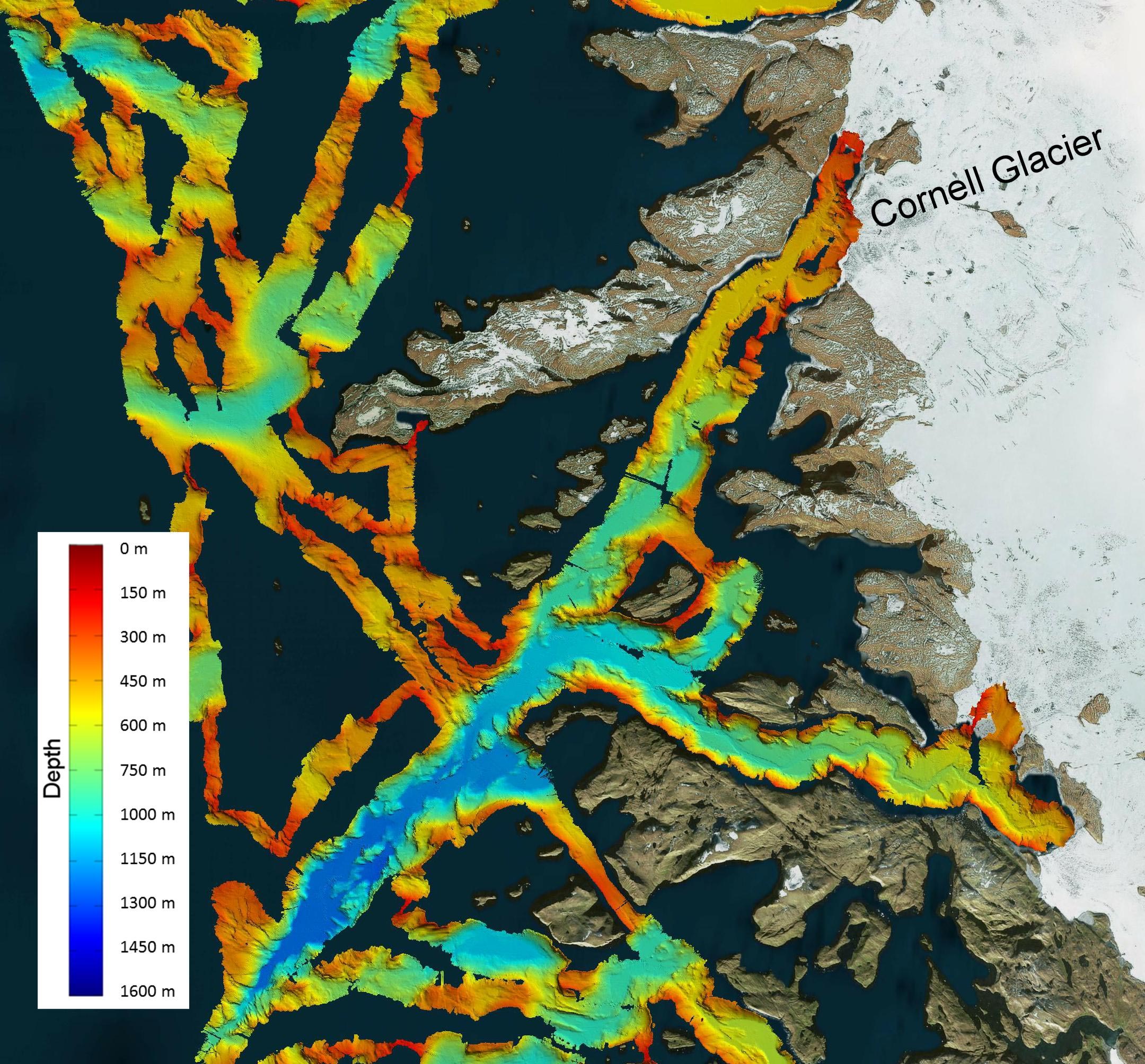
The complicated shape of the sea floor surrounding Greenland influences how readily this warm water melt can occur. It provides a barrier in some areas – preventing the deep, warmer water from the Atlantic Ocean from reaching glacier fronts. However, the underwater terrain, much like the terrain above water, includes other features like deep canyons. The canyons cut into the continental shelf, allowing the Atlantic waters in. Glaciers sitting in these waters will melt faster than those where the warm water is blocked by underwater ridges or sills.
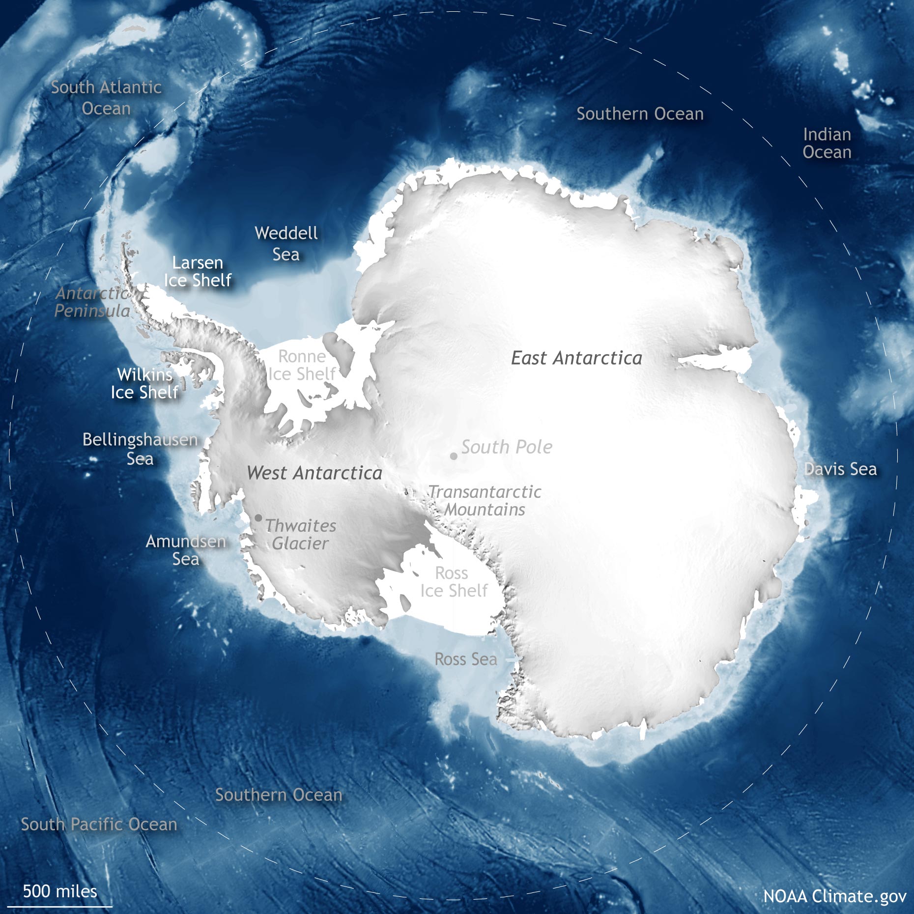
Ice Loss in Antarctica
In Antarctica, where similar surface and ocean melting processes occur, the topography and bedrock on which the ice sheet sits significantly influence the ice sheet’s stability and its contribution to sea level rise.
Researchers separate Antarctica into two regions based on the relationship between the ice and the bedrock beneath it. East Antarctica, the area east of the Transantarctic Mountains, is extremely high in elevation and has the thickest ice on the planet. The bedrock underneath the ice sheet is also mostly above sea level. These features help to keep the east side relatively stable. West Antarctica, on the other hand, is lower in elevation and most of the ice sheet there is thinner. Unlike the east, the ice sheet in West Antarctica sits on bedrock that is below sea level.
“In West Antarctica, we have these glaciers resting on bedrock that is under water. Like in Greenland, there is a layer of warmer ocean water below the cold surface layer. So this warm water is able to flow onto the continental shelf, and then all the way underneath the ice shelves – the floating ice that extends from glaciers and the ice sheet,” said NASA Jet Propulsion Laboratory scientist Helene Seroussi. “The water melts the ice shelves from below, which can cause them to thin and break off.”
That matters because the ice shelves act like corks. They hold back the ice that is flowing from upstream, slowing its approach to the ocean where it raises sea level. When the ice shelves calve, the cork is essentially removed, allowing more inland ice to flow freely into the ocean. Furthermore, this leads to retreat of the grounding zone – the area where the ice separates from the bedrock and begins to float.
The visualization shows how ocean currents flow around and under Pine Island Glacier in Antarctica. As the water makes its way underneath the ice shelf, it erodes the ice shelf from the bottom causing it to become thinner. The visualization was produced using the “Estimating the Circulation and Climate of the Ocean” (ECCO) V3 ocean circulation model, the 100 meter “Reference Elevation Model of Antarctica” (REMA) surface elevation and the 450 meter bed topography and ice thickness BedMachine Antarctica V1 datasets. The surface is mapped with scenes from NASA’s LandSat 8 satellite. Exaggeration factors of 4 and 15 – above and below sea level respectively – were used for clarity. Credit: NASA / Cindy Starr
“The grounding zone delineates floating ice, which is already accounted for in the sea level budget from grounded ice which is not accounted for in the budget,” said ICESat-2 scientist Kelly Brunt of NASA’s Goddard Space Flight Center and the University of Maryland. “Floating ice is like an ice cube floating in a glass. It doesn’t overflow the glass when it melts. But when non-floating ice is added to the ocean, it’s like adding more ice cubes to the glass which will cause the water level to rise.”
The bedrock in West Antarctica is also reverse sloping – meaning it is higher at the edges and gradually becomes deeper further inland. So each time the grounding zone retreats inland, thicker ice is exposed to the ocean water and the glacier or ice sheet becomes grounded in deeper water. This allows even more ice to flow from upstream into the ocean.
“It’s concerning in West Antarctica because as we push the grounding zones back, the downward, reverse slope means that there’s really no backstop, nothing to interrupt this cycle of melting and retreat,” said Brunt. “Our maps of the bedrock under the ice sheet are not as comprehensive as they are in Greenland, in part because Antarctica is far less accessible. Because of that, we really don’t know if there are any little bumps or peaks down there that might help to slow the retreat.”
West Antarctic glaciers like Thwaites and Pine Island are already retreating faster than they were in the past. This is problematic because they provide a main pathway for ice from the West Antarctic Ice Sheet to enter the Amundsen Sea and raise sea levels.
Overall, melting and ice loss have accelerated at both poles in recent years. The more we learn about the processes and interactions that cause it, some of which were discussed here, the better we’ll be able to accurately and precisely predict sea level rise far into the future.
Never miss a breakthrough: Join the SciTechDaily newsletter.
Follow us on Google and Google News.
1 Comment
“… if it were to melt all at once, would raise sea levels by nearly 215 feet (65 meters) – making the study and understanding of them … crucial to our near-term adaptability and our long-term survival …”
All at once? That is an absurd scenario because nothing short of bombardment by multiple asteroids at the poles could cause the ice sheets to melt all at once. What is important for the concerns of “near-term adaptability and our long-term survival” is the rate of melting. Most estimates for the unlikely event of the melting of all the ice sheets are thousands if not tens of thousands of years in the future! So much for the need for “near-term adaptability.” It is largely of academic interest what will happen in tens of thousands of years. Will the Milankovitch Cycles cause another glaciation? Will humans still be around?
“But with annual air temperatures in the Arctic increasing faster than anywhere else in the world, that balance is no longer achievable in Greenland.” Not so fast! More open water and warmer water should lead to increased evaporation and subsequent precipitation. As the more humid air rises up and over Greenland, it will precipitate out as snow. Instead of making unfounded claims, what scientists should be doing is studying the relationship between the variable of open water and surface temperature to predict downwind snow as the air masses experience orographic uplift.
“The glaciers are being melted by heat from above and below simultaneously.” The melting “above and below” is almost exclusively near the coasts, at low elevations. Most of the snow accumulation is at much higher elevations.
“When warm summer air melts the surface of a glacier, …” Anyone who lives in areas where it snows has observed that snow and ice can melt even when the air temperature is below freezing. It is the absorption of sunlight that is responsible for melting on the ground. The lapse rate tells us that the higher the elevation, the colder the air. What scientists should be studying is whether cloudiness is decreasing with increasing air temperatures. Increased evaporation suggests that the notoriously cloudy Arctic should get cloudier, thus decreasing the ice surface warming.
There is far too much hand waving in this article! It has all the flavor of snake oil. It comes across as propaganda to convince the scientifically illiterate that the “science is settled.” The science is never settled.