
For nearly 1,500 years, the Aquiry civilization shaped southwestern Amazonia, and new research suggests it supported a much larger population than previously believed.
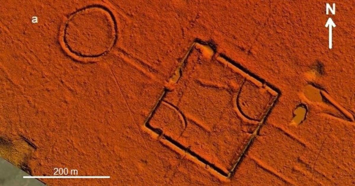
Beneath the dense forests of southwestern Amazonia, airborne lasers revealed a landscape covered with geometric earthworks, straight roads, and large ceremonial centers. The remains point to the Aquiry civilization, a multicultural society that occupied about 183,000 square kilometers between 600 BCE and 850 CE and may have supported millions of people.
Researchers examined a representative portion of this territory and documented more than 400 well-preserved examples of monumental ceremonial architecture, along with several sites from later settlements.
When the results were projected across the civilization’s entire range, the researchers produced a cautious estimate of more than 20,000 ancient ceremonial centers built from earth. The largest known complex extends across 50 hectares.
Millions may have lived there
Detailed archaeological surveys and radiocarbon dating indicate that between 1.25 million and 3 million people lived within Aquirian territory by the beginning of the first millennium.
That region represents less than 3 percent of Greater Amazonia. Its estimated population alone challenges earlier calculations placing the entire Amazon population between 1 million and 10 million people. The broader region may instead have supported tens of millions.
“Our findings overturn our understanding of the Amazon region’s past,” says Martti Pärssinen, emeritus professor at the University of Helsinki who led the study.
Plants shaped by human hands
The Aquiry transformed the surrounding forest as they built communities and produced food. They burned areas dominated by bamboo to create fields for maize, squash and manioc, as well as space for ceremonial centers and the broad roads connecting them.
They also cultivated gardens and actively managed useful tree species.
“The research shows that the human impact on the Amazon’s environment has been far greater than previously believed,” Pärssinen notes.
Several nutrient-rich trees now common in the region reflect prolonged human management. These include Brazil nut trees, peach palms, which also produce edible palm hearts, and other fruit-bearing species.
By favoring trees with cultural and practical value, Aquiry communities helped some species spread while reducing the presence of others.
“This has direct implications for our understanding of the region’s biocultural history. The civilization also affected ancient Amazonia’s carbon production and carbon balance, which should be better accounted for in future climate models,” Pärssinen adds.
LiDAR reveals a hidden landscape
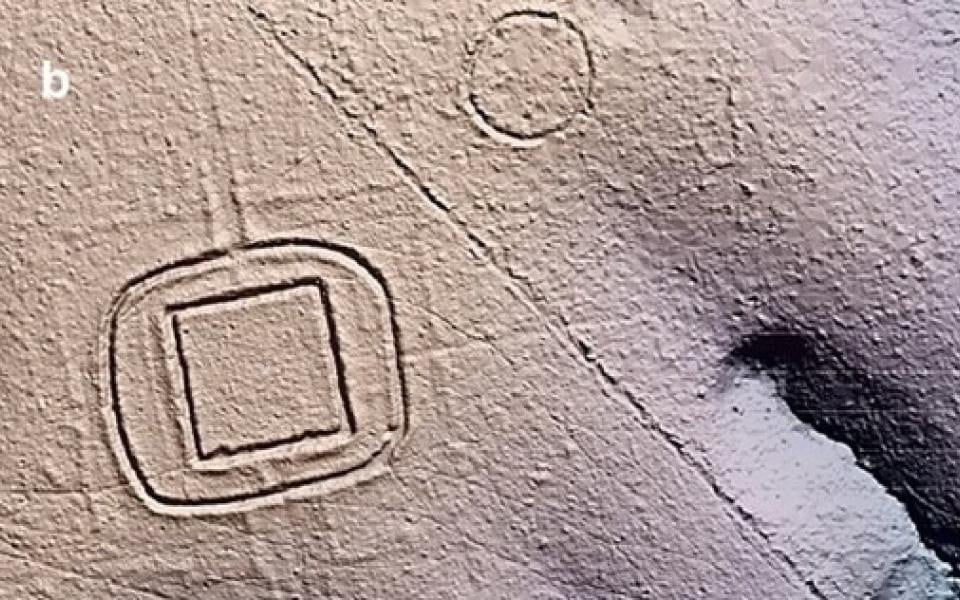
The investigation relied on airborne laser scanning known as LiDAR, a technology capable of mapping the shape of the land through thick vegetation. It exposed thousands of signs of ancient construction in rainforest areas that had received little previous study.
The flights scanned approximately 4,500 square kilometers. Researchers used more than half of that area for a systematic assessment of Aquiry earthworks.
“We flew long, roughly 450-kilometer straight transects, mapping a strip about one kilometer wide every ten kilometers. This allowed us to cover as large a continuous area as possible,” says Professor Juha Hyyppä of the Finnish Geospatial Research Institute (National Land Survey of Finland), who was responsible for the study’s technical execution.
Among the detected structures were large geometric formations and long, straight roads.
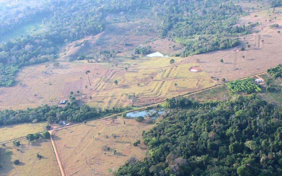
“Their varying dimensions, shapes, construction methods, and locations reflect the distinct geographical and cultural characteristics of the region,” notes Risto Kalliola, emeritus professor at the University of Turku.
Indigenous oral traditions describe the centers as places where communities maintained relationships with one another and with other significant beings. They also hosted gatherings, political decisions and demonstrations of generosity by leaders.
Activities held there included ritual dancing, music, shared meals, athletic competitions and ball games.
A vast civilization remains mysterious
Much about the Aquiry civilization is still unknown. Its territory covered an area roughly comparable to modern Syria.
Because suitable stone is scarce in this part of Amazonia, the civilization left no stone ruins. Its monumental earthworks, now known as Amazonian geoglyphs, nevertheless show the enormous scale of construction.
The name Aquiry derives from an Indigenous name for the Acre River. “This was not a single realm but a network of many different communities,” notes Pirjo Kristiina Virtanen, professor of Indigenous studies at the University of Helsinki.
Researchers do not know which languages these communities spoke or what names they used for themselves.
The cause of the civilization’s apparently sudden decline around 850 CE also remains uncertain. The classic Maya civilization in Central America underwent a similarly abrupt collapse at roughly the same time.
Reference: “Over 20,000 precolonial earthworks in the Southwest Amazonia” by Martti Pärssinen, Risto Kalliola, Alceu Ranzi, Eetu Puttonen, Rhuan Carlos Lopes, Pirjo Kristiina Virtanen, Francisco Apurinã, Kalle Ruokolainen, Juha Hyyppä, Antero Kukko, Mariana Campos, Fabio de Novaes, Markku Oinonen, Antonia D. Barbosa, Sanna Saunaluoma and Evandro Ferreira, 29 July 2026, Nature.
DOI: 10.1038/s41586-026-10835-7
Funding from a US-based donor
Never miss a breakthrough: Join the SciTechDaily newsletter.
Follow us on Google and Google News.
4 Comments
Yet no sign of agriculture vast enough to feed those millions… Or a great river (as the Euphrates or Ganges or the Nile) to provide it
Key graph: When the results were projected across the civilization’s entire range, the researchers produced a cautious estimate of more than 20,000 ancient ceremonial centers built from earth. The largest known complex extends across 50 hectares.
They are just making sh!t up at this point.
Hmmmm. “Between 1.25 million and 3 million people lived within Aquirian territory by the beginning of the first millennium” based on Trust Me Bro.
Fascinating information and photos of a very advanced culture. We now know of several cultures present in the Americas during very early times, now one more. Hopefully more information and more cultural centers may be found throughout the Americas. Thank you so much for this.