
Close Menu
    Facebook X (Twitter) Instagram
    SciTechDaily
    • Biology
    • Chemistry
    • Earth
    • Health
    • Physics
    • Science
    • Space
    • Technology
    Facebook X (Twitter) Pinterest YouTube RSS
    SciTechDaily
    Home»Earth»Satellites Map the Global Flow of Oil – Demand Has Collapsed Due to the Coronavirus Pandemic
    Earth

    Satellites Map the Global Flow of Oil – Demand Has Collapsed Due to the Coronavirus Pandemic

    By European Space AgencyApril 2, 2020No Comments4 Mins Read
    Facebook Twitter Pinterest Telegram LinkedIn WhatsApp Email Reddit
    Share
    Facebook Twitter LinkedIn Pinterest Telegram Email Reddit
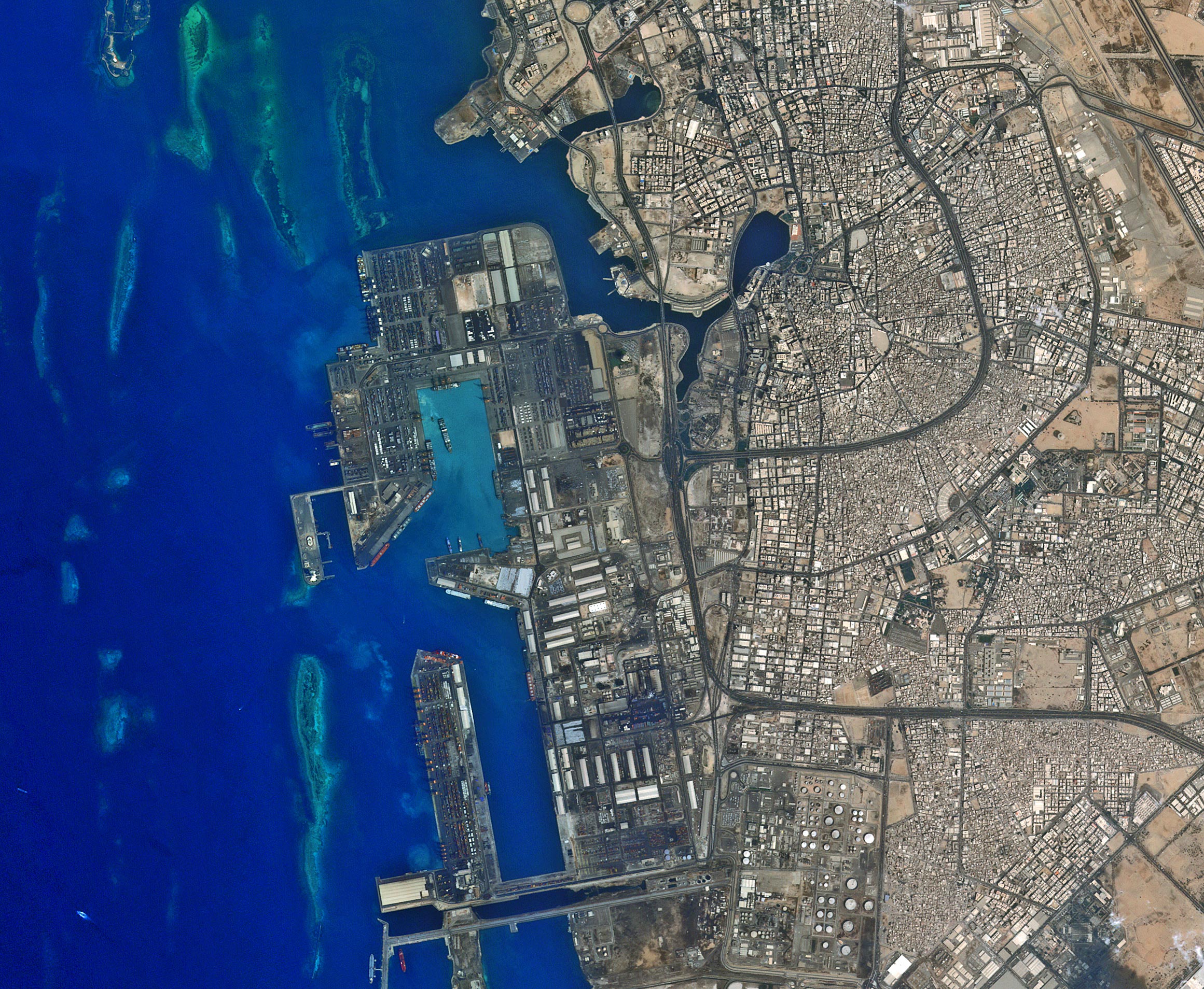
    Jeddah Seaport Saudi Arabia
    The city of Jeddah’s seaport on Saudi Arabia’s western coast is pictured in this image from the Kompsat-2 satellite. The second largest city in the country, Jeddah has a population of over five million people. The city is a gateway to Islam’s holiest city of Mecca, which lies about 60 km to the east, as well to the holy city of Medina, about 320 km north. Near the bottom of the image, the large circles are the tanks of an oil refinery. The oil industry comprises about 45% of Saudi Arabia’s gross domestic product, and 90% of export earnings. Saudi Arabia is the world’s number-one oil exporter, and therefore plays a major role in the global energy industry. Its policies on the production and export of oil, natural gas and petroleum products have a major impact on the energy market, as well as the global economy. Credit: KARI/ESA

    Demand for oil has collapsed due to the coronavirus pandemic just as supply is about to strengthen because of a dispute between Russia and Saudi Arabia. As a result, oil prices have sunk to levels not seen since 2002.

    As storage tanks around the world fill up, ESA-backed companies are using satellite data to map the flow of oil across the globe through shipping channels and pipelines in almost real-time. The analysis allows producers, traders, and governments to support the economy by taking informed decisions about the fuel that powers industry and heats homes.

    Crude oil is pumped from underground reservoirs into storage tanks that can be seen from space. These cylindrical tanks have lids that float on top of the oil, to minimize any loss through evaporation and reduce the risk of toxic, flammable gases escaping.

    Earth observation satellites circle the planet carrying optical cameras that can spot these tanks and measure their diameters.

    Such satellites carry synthetic aperture radar instruments that can detect the rise and fall in the height of the lids. This enables the volume of oil flowing into and out of the facility to be calculated.

    Some 65% of the world’s crude oil is traded by sea. Satellites can pick up the signals from automatic identification systems carried aboard large ships carrying oil, which enables people to track them as they load up with oil and transport it from one port to another.

    OilX, a digital oil analytics company founded in London in 2018 with ESA support, is using satellite data to map the flow of the world’s oil for customers including traders, government departments and investment banks.

    Florian Thaler, chief executive and co-founder of OilX, says: “The oil trader’s edge is no longer boots on the ground but eyes in the sky. We combine oil analytics, satellite technology and machine learning to deliver augmented intelligence to commodity markets. OilX is the world’s first digital oil analyst.”

    Other companies are using satellite data to gain insight into when new oil production is likely to come onstream.

    Gareth Morgan is founder and director of Terrabotics, which was founded in London in 2014 to monitor global natural resources supply chains throughout their lifecycles, and which has received ESA funding and business support.

    The company uses data from Earth observation satellites to watch the construction of oil and gas wells, waiting for tell-tale signs that they are about to start production. It provides market intelligence to commodities traders, competitive intelligence to other companies working in the region and objective reporting to investors.

    “Radar is a huge asset to us because of its global coverage and it works even through clouds and is quite robust to all weather conditions. We also use optical and infrared imagery to uniquely identify objects,” he says.

    “It is about providing objective information at a time of uncertainty. Using satellite data when you are remote and cannot access sites is very useful. We can give insight into what other people are doing – and even what they are not doing.”

    Nick Appleyard, Head of Downstream Business Applications at ESA, says: “ESA is helping to support the economy, as insights gleaned from space can guide global industries and help businesses to improve the speed, accuracy, and efficiency of their decisions.

    “We can see oil storage filling up around the world, because we have brought more oil out of the ground than we want to use. That means the price of oil has dropped and we should stop drilling for more. But that only happens accurately if the traders can see what is happening. The creative use of space data gives traders the information they need.”

    Never miss a breakthrough: Join the SciTechDaily newsletter.
    Follow us on Google and Google News.

    COVID-19 Energy European Space Agency Oil
    Share. Facebook Twitter Pinterest LinkedIn Email Reddit

    Related Articles

    Sulfur Dioxide Concentrations Drop 40% Over India During COVID-19

    Using Machine Learning to Accurately Predict Rock Thermal Conductivity for Enhanced Oil Production

    State of Emergency Declared After Massive Diesel Oil Leak Within the Arctic Circle

    COVID-19’s Remarkable Changes to the Environment Seen From Space [Video]

    Stunning Satellite Images Show Air Pollution Drop in India Following Coronavirus Lockdown

    Dramatic Satellite Images Show Air Pollution Remains Low as Europeans Stay at Home

    Satellite Captures Stunning Drop in Pollution Across Europe From COVID-19 Lockdown

    Shocking Video Shows Dramatic Nitrogen Dioxide Drop Over China Due to COVID-19 Lockdown

    Jaw-Dropping Video Shows Nitrogen Dioxide Emissions Drop Over Italy Due to Coronavirus

    Leave A Reply Cancel Reply

    • Facebook
    • Twitter
    • Pinterest
    • YouTube

    Don't Miss a Discovery

    Subscribe for the Latest in Science & Tech!

    Trending News

    FDA-Approved Drug Shows Promise for Reversing Osteoarthritis Damage

    11,000-Year-Old Grains Reveal a Surprise About the Origins of Agriculture

    This Common Type of Medication Is Linked to Slower Cognitive Decline

    Quantum Computer Solves a Problem in 15 Minutes That Classical Methods Can’t Practically Compute

    Taking the Stairs Could Cut Your Risk of Heart-Related Death by 39%

    Scientists Uncover a Surprising New Route for Stonehenge’s Most Mysterious Stone

    A Star Near the Milky Way’s Black Hole Is Losing Mass at an Astonishing Rate

    Scientists Solve a Vitamin B12 Mystery With an Unexpected Culprit

    Follow SciTechDaily
    • Facebook
    • Twitter
    • YouTube
    • Pinterest
    • Newsletter
    • RSS
    SciTech News
    • Biology News
    • Chemistry News
    • Earth News
    • Health News
    • Physics News
    • Science News
    • Space News
    • Technology News
    Recent Posts
    • Astronomers Discover a Ghostly River of Stars That Could Reveal Dark Matter
    • NASA Is Building a Moon Base – and the First Pieces Are Already Coming Together
    • Something Mysterious Just Passed Between Earth and a Distant Star
    • This Natural Gut Compound Could Point to Better Treatments for IBD
    • Your Liver Runs on a Clock – and It Could Change How We Treat Metabolic Disease
    Copyright © 1998 - 2026 SciTechDaily. All Rights Reserved.
    • Science News
    • About
    • Contact
    • Editorial Board
    • Privacy Policy
    • Terms of Use

    Type above and press Enter to search. Press Esc to cancel.