
Close Menu
    Facebook X (Twitter) Instagram
    SciTechDaily
    • Biology
    • Chemistry
    • Earth
    • Health
    • Physics
    • Science
    • Space
    • Technology
    Facebook X (Twitter) Pinterest YouTube RSS
    SciTechDaily
    Home»Earth»Devastating Wildfires in Oregon Captured by NASA’s Aqua Satellite
    Earth

    Devastating Wildfires in Oregon Captured by NASA’s Aqua Satellite

    By Lynn Jenner, NASASeptember 12, 2020No Comments3 Mins Read
    Facebook Twitter Pinterest Telegram LinkedIn WhatsApp Email Reddit
    Share
    Facebook Twitter LinkedIn Pinterest Telegram Email Reddit
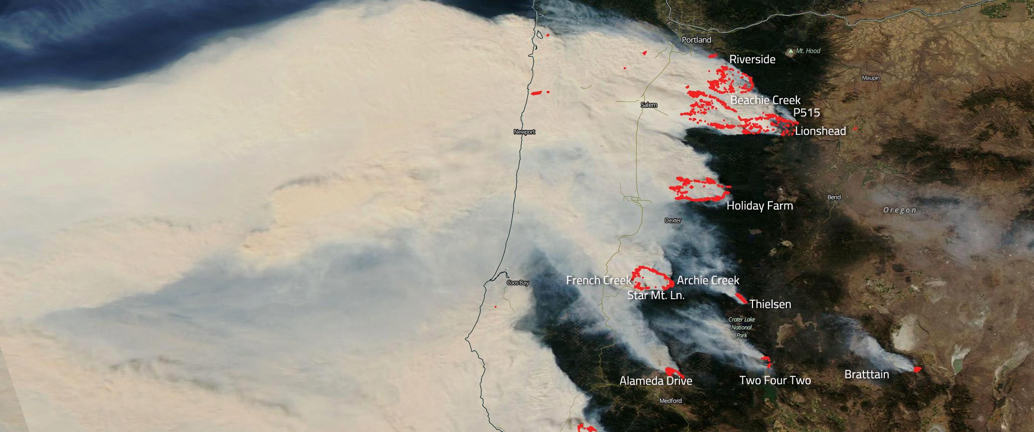
    Aqua Satellite Oregon Wildfires September 2020 Labeled
    NASA’s Aqua satellite image of wildfires in Oregon. Credit: NASA Worldview

    NASA’s Aqua captured this image of a huge number of wildfires that have broken out in Oregon. Some began in August, but the majority started after an unprecedented and historically rare windstorm that swept through the Cascade foothills in the afternoon of Monday, September 7 through the morning of Tuesday, September 8. Wind gusts up to 65 mph were clocked during the event. The timing of the windstorm was unusual because those strong east winds usually occur in the dead of winter — not in early September. In addition to the heat, it is another example of the changing weather patterns that are being seen. Some fires in Oregon were already aflame since they began in mid-August, but the size of the conflagrations was small. In fact, the Beachie Creek fire on the morning of September 7 was only 469 acres. After the windstorm began the fire grew overnight to over 131,000 acres driven by high winds and extremely dry fuels. Other fires grew as well, and a large number of fires were started on September 8, most likely from flaming debris or perhaps by lightning strikes. Whatever the cause, the winds overnight drove those fires to expand exponentially and quickly as well.

    The smoke from fires is seen cascading off the coast into the Pacific Ocean traveling more than 600 miles just in this image. It is striking how thick and concentrated the smoke is in this image, and many cities and towns up and down the entire West Coast are reporting almost “nightlike” conditions and red-orange skies created by particles in the air blocking out all other colors.
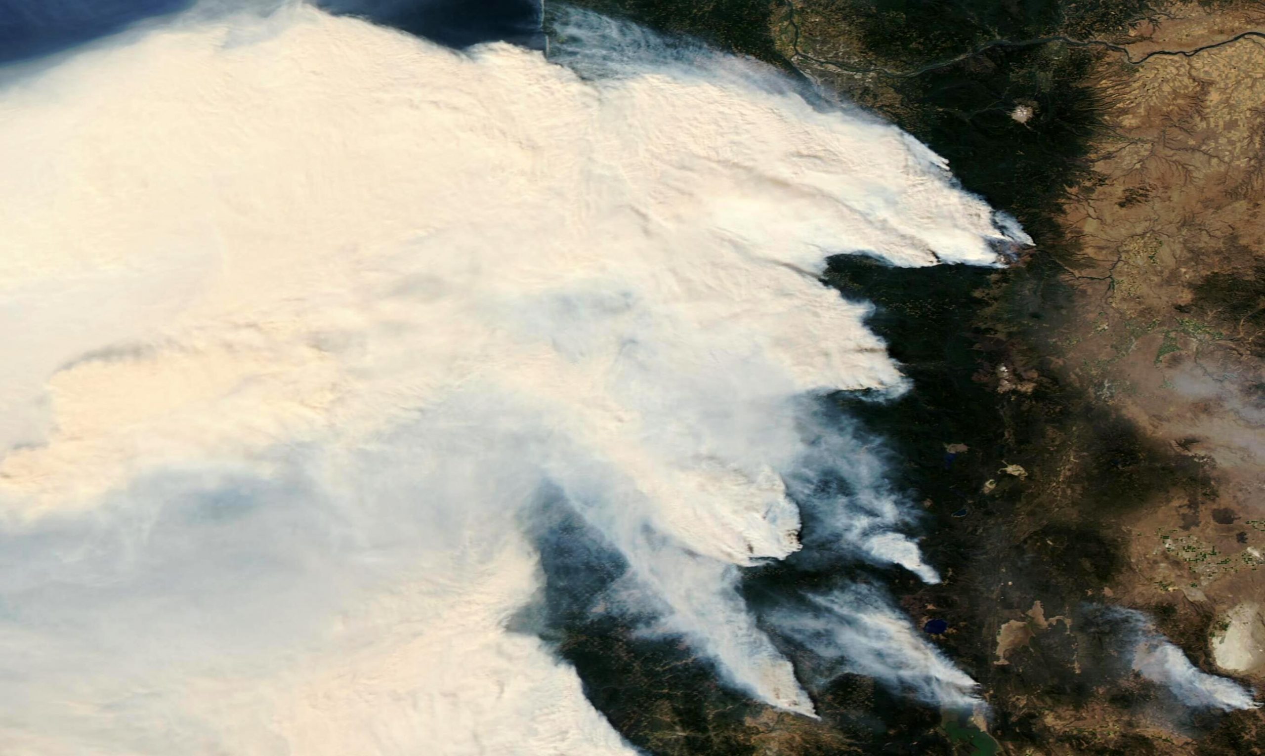
    Aqua Satellite Oregon Wildfires September 2020
    NASA’s Aqua satellite image is the same as the one above but was created without labels. Credit: NASA Worldview

    NASA’s satellite instruments are often the first to detect wildfires burning in remote regions, and the locations of new fires are sent directly to land managers worldwide within hours of the satellite overpass. Together, NASA instruments detect actively burning fires, track the transport of smoke from fires, provide information for fire management, and map the extent of changes to ecosystems, based on the extent and severity of burn scars. NASA has a fleet of Earth-observing instruments, many of which contribute to our understanding of fire in the Earth system. Satellites in orbit around the poles provide observations of the entire planet several times per day, whereas satellites in a geostationary orbit provide coarse-resolution imagery of fires, smoke, and clouds every five to 15 minutes.

    NASA’s Earth Observing System Data and Information System (EOSDIS) Worldview application provides the capability to interactively browse over 700 global, full-resolution satellite imagery layers and then download the underlying data. Many of the available imagery layers are updated within three hours of observation, essentially showing the entire Earth as it looks “right now.” Actively burning fires, detected by thermal bands, are shown as red points. Image Courtesy: NASA Worldview, Earth Observing System Data and Information System (EOSDIS). Caption: Lynn Jenner with information from Inciweb and the Oregon Wildfire resources page.

    Never miss a breakthrough: Join the SciTechDaily newsletter.
    Follow us on Google and Google News.

    NASA Wildfires
    Share. Facebook Twitter Pinterest LinkedIn Email Reddit

    Related Articles

    Satellite Imagery Shows Ferocious Fires in Australia Intensify

    NASA: Amazon Fires Were Fueled by Drought-Stressed Forest

    NASA’s Terra Satellite Images California’s Kincade Fire Burn Scar From Space

    NASA Satellite Image – Southern California’s Getty Fire Continues to Burn

    NASA’s Terra Satellite Images the Destructive Kincaid Fire in Sonoma County, California

    NASA Satellite Data Shows Climate Change’s Impact on Fires [Video]

    NASA’s ECOSTRESS Detects Amazon Fires from International Space Station

    NASA Satellite Image: Amazon Fires Shroud South America in Smoke

    Carbon Monoxide From Brazil Fires Mapped by NASA Satellite

    Leave A Reply Cancel Reply

    • Facebook
    • Twitter
    • Pinterest
    • YouTube

    Don't Miss a Discovery

    Subscribe for the Latest in Science & Tech!

    Trending News

    Don’t Miss: A Brilliant Venus and Glowing Harvest Moon Light Up the Sky

    New Twist on the Einstein Problem Reveals Unexpected Physics

    JWST Captures Stunning Evidence of How Supermassive Black Holes Feed

    Early Exercise May Permanently Change How Much Energy the Body Uses To Move

    New Molecule Wipes Out Aggressive Lymphoma Tumors in Mice in Just 11 Days

    The Human Family Tree May Need a Major Rewrite

    Scientists Find a Surprising Cancer-Fighting Effect in Dark Sweet Cherries

    New AI Detects Hidden Warning Signs of Solar Eruptions Hours Before They Emerge

    Follow SciTechDaily
    • Facebook
    • Twitter
    • YouTube
    • Pinterest
    • Newsletter
    • RSS
    SciTech News
    • Biology News
    • Chemistry News
    • Earth News
    • Health News
    • Physics News
    • Science News
    • Space News
    • Technology News
    Recent Posts
    • Africa’s Giant Herbivores Were Disappearing Millions of Years Before Humans Could Hunt Them
    • This Utah Mountain Is Hiding Enough Ice To Fill 600 Olympic Pools
    • Vagus Nerve Stimulation Could Unlock the Brain’s Hidden Learning Potential
    • Your Mother’s Age May Leave a Biological Mark That Lasts for Generations
    • Women Who Ate More Antioxidants Had Strikingly Lower Rates of Cervical Cancer
    Copyright © 1998 - 2026 SciTechDaily. All Rights Reserved.
    • Science News
    • About
    • Contact
    • Editorial Board
    • Privacy Policy
    • Terms of Use

    Type above and press Enter to search. Press Esc to cancel.