Close Menu
    Facebook X (Twitter) Instagram
    SciTechDaily
    • Biology
    • Chemistry
    • Earth
    • Health
    • Physics
    • Science
    • Space
    • Technology
    Facebook X (Twitter) Pinterest YouTube RSS
    SciTechDaily
    Home»Earth»NASA’s Terra Satellite Images the Destructive Kincaid Fire in Sonoma County, California
    Earth

    NASA’s Terra Satellite Images the Destructive Kincaid Fire in Sonoma County, California

    By Lynn Jenner, NASAOctober 26, 2019No Comments3 Mins Read
    Facebook Twitter Pinterest Telegram LinkedIn WhatsApp Email Reddit
    Share
    Facebook Twitter LinkedIn Pinterest Telegram Email Reddit
    Sonoma County Kincaid Fire
    NASA Worldview, Earth Observing System Data and Information System (EOSDIS)

    Update 10/28/19: There is a New Satellite Image of California’s Kincaid Fire.

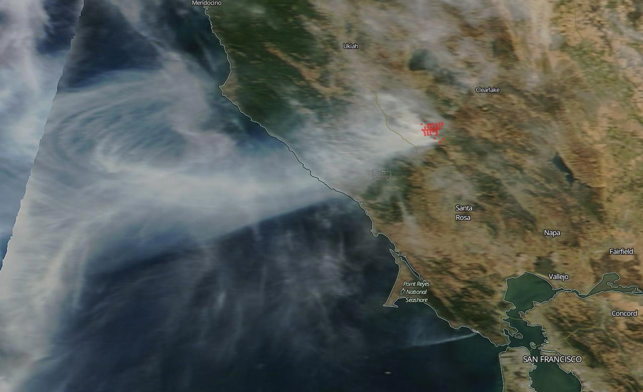
    NASA’s Terra satellite captured an image of the Kincaid wildfire located in Northern California’s Sonoma County which broke out on Wednesday night, October 23, 2019, and has grown to over 20,000 acres in less than 48 hours. This natural-color image was taken on October 24, 2019, by the MODIS (Moderate Resolution Imaging Spectroradiometer) instrument on the Terra satellite. It pinpoints the area of the fire which is located in the scenic wine country of northern California and has forced the evacuation of over 2,000 people so far.

    The wind and low humidity have contributed to the swift movement of the fire in such a short amount of time growing to 10,000 acres in a matter of hours. The cause of the outbreak is still under investigation. Pacific Gas and Electric has cut power to a half million residents to avoid more wildfire outbreaks as humidity drops and winds pick up. Some gusts have been reported at up to 70 mph (113 kph). The fire is only 5% contained at present. Structures and power lines are threatened by this blaze and firefighters are continuing to construct containment lines. CA Department of Forestry and Fire Protection reports that 49 structures have been destroyed.

    NASA’s satellite instruments are often the first to detect wildfires burning in remote regions, and the locations of new fires are sent directly to land managers worldwide within hours of the satellite overpass. Together, NASA instruments detect actively burning fires, track the transport of smoke from fires, provide information for fire management, and map the extent of changes to ecosystems, based on the extent and severity of burn scars. NASA has a fleet of Earth-observing instruments, many of which contribute to our understanding of fire in the Earth system. Satellites in orbit around the poles provide observations of the entire planet several times per day, whereas satellites in a geostationary orbit provide coarse-resolution imagery of fires, smoke, and clouds every five to 15 minutes.

    NASA’s Earth Observing System Data and Information System (EOSDIS) Worldview application provides the capability to interactively browse over 700 global, full-resolution satellite imagery layers and then download the underlying data. Many of the available imagery layers are updated within three hours of observation, essentially showing the entire Earth as it looks “right now.” Actively burning fires, detected by thermal bands, are shown as red points.

    Never miss a breakthrough: Join the SciTechDaily newsletter.
    Follow us on Google and Google News.

    MODIS NASA Terra Spacecraft Wildfires
    Share. Facebook Twitter Pinterest LinkedIn Email Reddit

    Related Articles

    Satellite Imagery Shows Ferocious Fires in Australia Intensify

    NASA: Amazon Fires Were Fueled by Drought-Stressed Forest

    NASA’s Terra Satellite Images California’s Kincade Fire Burn Scar From Space

    NASA Satellite Image – Southern California’s Getty Fire Continues to Burn

    NASA Satellite Data Shows Climate Change’s Impact on Fires [Video]

    NASA’s ECOSTRESS Detects Amazon Fires from International Space Station

    NASA Satellite Image: Amazon Fires Shroud South America in Smoke

    Carbon Monoxide From Brazil Fires Mapped by NASA Satellite

    Plankton-Fueled Agulhas Current Ocean Eddy Is 93 Miles Wide

    Leave A Reply Cancel Reply

    • Facebook
    • Twitter
    • Pinterest
    • YouTube

    Don't Miss a Discovery

    Subscribe for the Latest in Science & Tech!

    Trending News

    Your Blood Pressure Reading Could Be Wrong Because of One Simple Mistake

    Astronomers Stunned by Ancient Galaxy With No Spin

    Physicists May Be on the Verge of Discovering “New Physics” at CERN

    Scientists Solve 320-Million-Year Mystery of Reptile Skin Armor

    Scientists Say This Daily Walking Habit May Be the Secret to Keeping Weight Off After Dieting

    New Therapy Rewires the Brain To Restore Joy in Depression Patients

    Giant Squid Detected off Western Australia in Stunning Deep-Sea Discovery

    Popular Sugar-Free Sweetener Linked to Liver Disease, Study Warns

    Follow SciTechDaily
    • Facebook
    • Twitter
    • YouTube
    • Pinterest
    • Newsletter
    • RSS
    SciTech News
    • Biology News
    • Chemistry News
    • Earth News
    • Health News
    • Physics News
    • Science News
    • Space News
    • Technology News
    Recent Posts
    • Scientists Discover Signs Africa May Be Splitting Apart Beneath Zambia
    • New Stroke Study Challenges Decades-Old Medical Beliefs
    • These Simple Plant Foods Are Linked to Lower Blood Pressure
    • Common Blood Pressure Drug Supercharges Cancer Treatment in Surprising New Study
    • Key Magic Mushroom Ingredient Increases Laziness and Reduces Aggression
    Copyright © 1998 - 2026 SciTechDaily. All Rights Reserved.
    • Science News
    • About
    • Contact
    • Editorial Board
    • Privacy Policy
    • Terms of Use

    Type above and press Enter to search. Press Esc to cancel.