Close Menu
    Facebook X (Twitter) Instagram
    SciTechDaily
    • Biology
    • Chemistry
    • Earth
    • Health
    • Physics
    • Science
    • Space
    • Technology
    Facebook X (Twitter) Pinterest YouTube RSS
    SciTechDaily
    Home»Earth»Massive Burn Scars Across California Revealed in Stunning NASA Terra Satellite Images
    Earth

    Massive Burn Scars Across California Revealed in Stunning NASA Terra Satellite Images

    By Lynn Jenner, NASA's Goddard Space Flight CenterAugust 28, 2020No Comments4 Mins Read
    Facebook Twitter Pinterest Telegram LinkedIn WhatsApp Email Reddit
    Share
    Facebook Twitter LinkedIn Pinterest Telegram Email Reddit
    NASA Terra Satellite August 26 2020
    NASA’s Terra satellite captures this image of the burn scars from both the LNU Lightning fire complex and the SCU Lightning fire complex in California on August 26, 2020. Credit: NASA

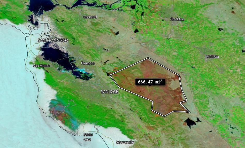
    On August 26, 2020, NASA’s Terra satellite was able to image the two areas in California where the fires have been most active and using the false color reflectance bands on the MODIS (Moderate Resolution Infrared Spectroradiometer) instrument aboard. Using these bands, the burned areas or fire-affected areas are characterized by deposits of charcoal and ash, removal of vegetation and/or the alteration of vegetation structure. When bare soil becomes exposed, the brightness in Band 1 may increase, but that may be offset by the presence of black carbon residue; the near infrared (Band 2) will become darker, and Band 7 becomes more reflective. When assigned to red in the image, Band 7 will show burn scars as deep or bright red, depending on the type of vegetation burned, the amount of residue, or the completeness of the burn. The bands are colored as such: Red = Band 7, Green = Band 2, Blue = Band 1.

    LNU Lightning Complex Burn Scar
    The LNU Lightning Complex burn scar is measured using the measurement tool with the Worldview Application. Credit: NASA Worldview

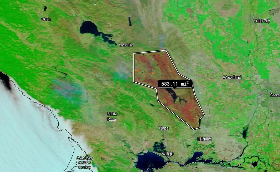
    The LNU (Lake Napa Unit) Lightning Complex fire is near the Napa Valley in northern California and the SCU (Santa Clara Unit) Lightning Complex fire is near Santa Clara in northern California as well. Both fires began during a particularly large number of lighting strikes from thunderstorms on August 17-18. The measurement tool within the Worldview application can measure distances in miles and kilometers, and it can also measure square miles. This tool was used to show the square miles that have been burned to date in both the LNU and the SCU Lightning complex fires using the reflectance band colors to outline and measure the burn scars.

    The LNU Lightning complex fire is listed as being 33 percent contained on the CAL Fire website on August 27. Using the Worldview measurement tool the fire is approximately 583.11 square miles in size from the satellite image taken on August 26. The SCU Lightning complex fire which CAL Fire reports as being 35 percent contained is approximately 666.47 square miles from the satellite image taken on August 16. The SCU fire has burned 368,671 acres and the LNU fire has burned 368,868 according to the CAL fire website on August 27. These two complexes continue to be the second and third largest fires in California’s history. Only the 2018 Mendocino Complex fire was larger at 459,123 acres.  With the exception of two fires (2007 and 1932) the top ten largest fires in California’s history have all happened within the last decade.

    SCU Lightning Complex Burn Scar
    The SCU Lightning Complex burn scar is measured using the measurement tool with the Worldview Application. Credit: NASA Worldview

    NASA’s satellite instruments are often the first to detect wildfires burning in remote regions, and the locations of new fires are sent directly to land managers worldwide within hours of the satellite overpass. Together, NASA instruments detect actively burning fires, track the transport of smoke from fires, provide information for fire management, and map the extent of changes to ecosystems, based on the extent and severity of burn scars.

    NASA’s Earth Observing System Data and Information System (EOSDIS) Worldview application provides the capability to interactively browse over 700 global, full-resolution satellite imagery layers and then download the underlying data. Many of the available imagery layers are updated within three hours of observation, essentially showing the entire Earth as it looks “right now.” Actively burning fires, detected by thermal bands, are shown as red points. Images Courtesy: NASA Worldview, Earth Observing System Data and Information System (EOSDIS).

    Never miss a breakthrough: Join the SciTechDaily newsletter.
    Follow us on Google and Google News.

    NASA NASA Goddard Space Flight Center Wildfires
    Share. Facebook Twitter Pinterest LinkedIn Email Reddit

    Related Articles

    NASA’s Terra Satellite Captures Smoky Pall Over California After Unprecedented Lightning Strikes Ignite More Than 650 Wildfires

    1200+ Mile Trail of Smoke Stretches Across California in These NASA Terra Images of the Wildfires

    63 Mile Smoke Trail From Bighorn Fire Captured by NOAA/NASA Satellite

    Latest NASA Satellite Observations of Australia’s Bushfires Show Smoke Going Round the World

    World Path of Smoke and Aerosols From Australian Fires Animated by Fleet of NASA Satellites

    Satellite View of Australian Fires Shows Severe Burn Scars Across Kangaroo Island

    Stunning Satellite Images As Rain Brings Relief to Australia’s Fires

    Satellite Imagery Shows Ferocious Fires in Australia Intensify

    NASA Satellite Image: Amazon Fires Shroud South America in Smoke

    Leave A Reply Cancel Reply

    • Facebook
    • Twitter
    • Pinterest
    • YouTube

    Don't Miss a Discovery

    Subscribe for the Latest in Science & Tech!

    Trending News

    Popular Vitamin B3 Supplements May Help Cancer Cells Survive, Scientists Warn

    Scientists Discover Strange Property of Rice and Turn It Into a Smart Material

    NASA Artemis II Skips Burn As Astronaut Captures Stunning View of Earth

    NASA’s Artemis II: Humans Just Left Earth Orbit for the First Time Since 1972

    What Causes Chronic Pain? Scientists Identify Key Culprit in the Brain

    Semaglutide Shows Surprising Mental Health Benefits in Massive 100,000-Person Study

    This Liquid Snapped Instead of Flowing and Scientists Were Shocked

    Breakthrough Alzheimer’s Drug Rewires the Brain Instead of Just Clearing Plaques

    Follow SciTechDaily
    • Facebook
    • Twitter
    • YouTube
    • Pinterest
    • Newsletter
    • RSS
    SciTech News
    • Biology News
    • Chemistry News
    • Earth News
    • Health News
    • Physics News
    • Science News
    • Space News
    • Technology News
    Recent Posts
    • Astronomers Discover the Most Pristine Star Ever Found
    • New Study Suggests Gravitational Waves May Have Created Dark Matter
    • Scientists Solve 60-Year-Old Mystery of Strange Magnetic Surges Above the Moon
    • Scientists Discover How Multiple Sclerosis Kills Brain Cells
    • Scientists Discover Why the Brain Gets Stuck in Schizophrenia
    Copyright © 1998 - 2026 SciTechDaily. All Rights Reserved.
    • Science News
    • About
    • Contact
    • Editorial Board
    • Privacy Policy
    • Terms of Use

    Type above and press Enter to search. Press Esc to cancel.