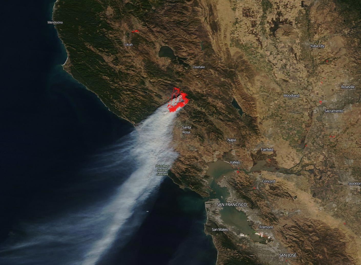
California’s devastating Kincaid Fire located in Sonoma County has grown to over 66,000 acres and NASA’s Terra satellite captured this dramatic image of the smoke plume cascading down the coast. The fire is located northeast of Geyserville and is classified as a “vegetation fire” and its origins are still under investigation.
CAL Fire released an update on this destructive fire today, October 28 at 7 a.m. PDT. The major impediment in fighting this fire seems to be the weather. CAL Fire reports that: “A Red Flag warning will continue through Monday morning. 40-50 mph (41-80 kph) wind gusts are still a possibility throughout the evening while narrow roads and steep terrain are making access to the fire areas very difficult. These Northeast winds coupled with low humidity create critical fire weather conditions. Firefighters will continue to mitigate structure threats and find opportunities to construct control lines.” So weather coupled with the steep, narrow terrain makes controlling and containing the fire especially challenging. Well over 100,000 residents in the area have been evacuated and according to CAL fire 79,675 structures are threatened and 96 structures have already been destroyed. Over 70,000 of the structures threatened are homes.
NASA’s satellite instruments are often the first to detect wildfires burning in remote regions, and the locations of new fires are sent directly to land managers worldwide within hours of the satellite overpass. Together, NASA instruments detect actively burning fires, track the transport of smoke from fires, provide information for fire management, and map the extent of changes to ecosystems, based on the extent and severity of burn scars. NASA has a fleet of Earth-observing instruments, many of which contribute to our understanding of fire in the Earth system. Satellites in orbit around the poles provide observations of the entire planet several times per day, whereas satellites in a geostationary orbit provide coarse-resolution imagery of fires, smoke, and clouds every five to 15 minutes.
NASA’s Earth Observing System Data and Information System (EOSDIS) Worldview application provides the capability to interactively browse over 700 global, full-resolution satellite imagery layers and then download the underlying data. Many of the available imagery layers are updated within three hours of observation, essentially showing the entire Earth as it looks “right now.” This satellite image was collected on October 27, 2019, by the Terra satellite using the MODIS (Moderation Resolution Imaging Spectroradiometer). Actively burning fires, detected by thermal bands, are shown as red points.
Never miss a breakthrough: Join the SciTechDaily newsletter.
Follow us on Google and Google News.