Close Menu
    Facebook X (Twitter) Instagram
    SciTechDaily
    • Biology
    • Chemistry
    • Earth
    • Health
    • Physics
    • Science
    • Space
    • Technology
    Facebook X (Twitter) Pinterest YouTube RSS
    SciTechDaily
    Home»Earth»Stunning Satellite Images As Rain Brings Relief to Australia’s Fires
    Earth

    Stunning Satellite Images As Rain Brings Relief to Australia’s Fires

    By Lynn Jenner, NASAJanuary 6, 2020No Comments5 Mins Read
    Facebook Twitter Pinterest Telegram LinkedIn WhatsApp Email Reddit
    Share
    Facebook Twitter LinkedIn Pinterest Telegram Email Reddit
    NOAA NASA Satellite Image Australia Fire
    NOAA-NASA captured this stunning satellite image of the areas affected by the fire and smoke on January 4, 2020. The rains did not come in to affect the fires until January 5-6. In this satellite image, the smoke coming off the fires can be clearly seen as billowing clouds of brown-gray in three separate plumes from north to south. Credit: NASA Worldview, Earth Observing System Data and Information System (EOSDIS)

    NASA satellite data continues to provide a look at the smoke and aerosols generated by the massive fires in Australia. Although rain fell on parts of the fire-ravaged areas in New South Wales and Victoria, Australia (and in some areas the rain was torrential), officials are already warning residents that the fires (and resultant smoke and aerosols) will return to their former state with a vengeance by Thursday when hot, dry weather and winds return.

    The next misery facing Australia is the chance that fires will soon merge creating mega-fires to fight in the already devastated areas. Rains should do nothing more than give residents a moment to regroup before the fires regain their former wrath. Even with the respite from the rain, the haze and smoke in the area remain in the hazardous range.

    NOAA-NASA captured this stunning satellite image of the areas affected by the fire and smoke on January 4, 2020. The rains did not come in to affect the fires until January 5-6. In this satellite image, the smoke coming off the fires can be clearly seen as billowing clouds of brown-gray in three separate plumes from north to south.

    Suomi NPP Satellite Image Australia Fire
    This Suomi-NPP satellite image from January 4, 2020 shows the aerosols within the smoke plumes from the fires in Australia. The deeper the red in the image, the higher amount of aerosols are present in the smoke. The Aerosol Index layer is useful for identifying and tracking the long-range transport of volcanic ash from volcanic eruptions, smoke from wildfires or biomass burning events and dust from desert dust storms, even tracking over clouds and areas of snow and ice. Credit: NOAA/NASA

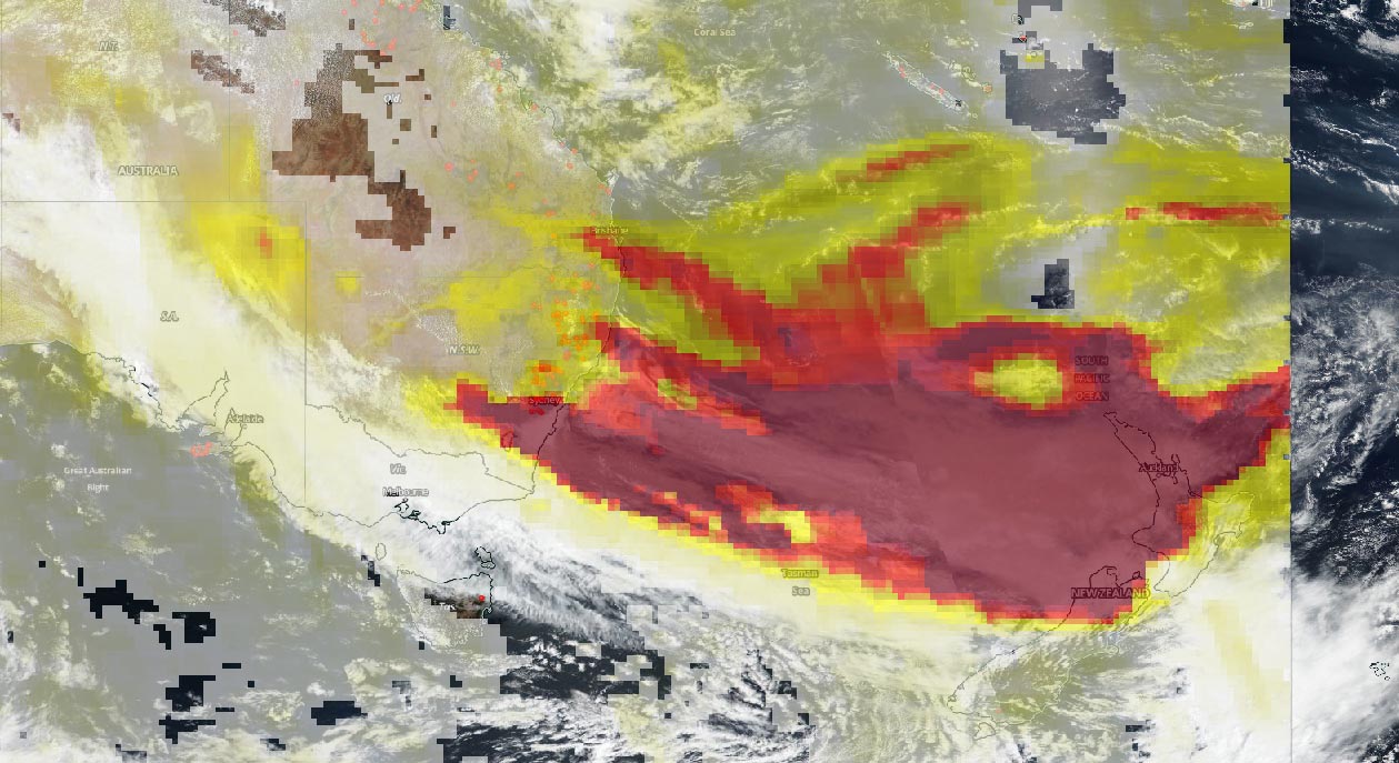
    The image above shows the massive amounts of particles within the smoke that are rising into the atmosphere.  These particles consist of soot, dust, and other dangerous inhalants which can affect human health. Aerosols compromise human health when inhaled by people with asthma or other respiratory illnesses. Aerosols also have an effect on the weather and climate. The Suomi NPP satellite OMPS (Ozone Mapper and Profiler Suite) instrument onboard found that the majority of the smoke spewing from the fires has aerosols at or above the highest levels that can be measured by the instrument. The deep red color is indicative of the highest amount of aerosols within the smoke plumes. As the colors back off from deep red to red, orange, yellow, and lighter yellow the aerosols lessen within the smoke.

    NASA Aqua MODIS Satellite Image Australia Fire
    This image was taken by NASA’s Aqua satellite using the MODIS (Moderate Resolution Imaging Spectroradiometer) instrument on January 5, 2020. Credit: NASA

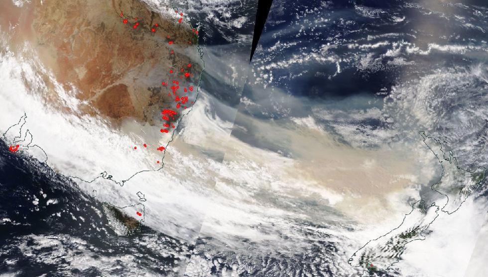
    The image above is just a reminder that smoke does not stay in one place. Looking at Australia from a farther distance in this Aqua satellite image taken on January 5, 2020, it is evident that the smoke plumes coming off the fires are traveling on wind currents and are heading for the neighboring country of New Zealand which is just over a thousand miles away. The skies over New Zealand, once clear, are now turning a very dangerous orange hue and by Sunday, January 5, the sun had been blotted out in Auckland, New Zealand. Beyond coloring the sky an angry orange, dirty orange-brown soot can now be found on the glaciers in South Island, New Zealand.

    NASA’s satellite instruments are often the first to detect wildfires burning in remote regions, and the locations of new fires are sent directly to land managers worldwide within hours of the satellite overpass. Together, NASA instruments detect actively burning fires, track the transport of smoke from fires, provide information for fire management, and map the extent of changes to ecosystems, based on the extent and severity of burn scars. NASA has a fleet of Earth-observing instruments, many of which contribute to our understanding of fire in the Earth system. Satellites in orbit around the poles provide observations of the entire planet several times per day, whereas satellites in a geostationary orbit provide coarse-resolution imagery of fires, smoke, and clouds every five to 15 minutes.

    NASA’s Earth Observing System Data and Information System (EOSDIS) Worldview application provides the capability to interactively browse over 700 global, full-resolution satellite imagery layers and then download the underlying data. Many of the available imagery layers are updated within three hours of observation, essentially showing the entire Earth as it looks “right now.” Actively burning fires, detected by thermal bands, are shown as red points.

    Never miss a breakthrough: Join the SciTechDaily newsletter.
    Follow us on Google and Google News.

    Australia NASA NASA Goddard Space Flight Center NOAA Weather Wildfires
    Share. Facebook Twitter Pinterest LinkedIn Email Reddit

    Related Articles

    Massive Saharan Dust Aerosol Blanket Analyzed by NASA-NOAA Suomi NPP Satellite

    63 Mile Smoke Trail From Bighorn Fire Captured by NOAA/NASA Satellite

    Latest NASA Satellite Observations of Australia’s Bushfires Show Smoke Going Round the World

    World Path of Smoke and Aerosols From Australian Fires Animated by Fleet of NASA Satellites

    Satellite View of Australian Fires Shows Severe Burn Scars Across Kangaroo Island

    Satellite Imagery Shows Ferocious Fires in Australia Intensify

    NASA Satellite Image: Amazon Fires Shroud South America in Smoke

    NASA Study Reveals Multi-Year Ice Declining Faster than Perennial Ice that Surrounds It

    NASA’s GISS Releases Data Showing 2011 was Ninth-Warmest Year on Record

    Leave A Reply Cancel Reply

    • Facebook
    • Twitter
    • Pinterest
    • YouTube

    Don't Miss a Discovery

    Subscribe for the Latest in Science & Tech!

    Trending News

    Popular Sugar-Free Sweetener Linked to Liver Disease, Study Warns

    What Is Hantavirus? The Deadly Disease Raising Alarm Worldwide

    Scientists Just Discovered How the Universe Builds Monster Black Holes

    Scientists Unveil New Treatment Strategy That Could Outsmart Cancer

    A Simple Vitamin May Hold the Key to Treating Rare Genetic Diseases

    Scientists Think the Real Fountain of Youth May Be Hiding in Your Gut

    Ravens Don’t Follow Wolves, They Predict Them

    This Common Knee Surgery May Be Doing More Harm Than Good

    Follow SciTechDaily
    • Facebook
    • Twitter
    • YouTube
    • Pinterest
    • Newsletter
    • RSS
    SciTech News
    • Biology News
    • Chemistry News
    • Earth News
    • Health News
    • Physics News
    • Science News
    • Space News
    • Technology News
    Recent Posts
    • Why Are So Many New Fathers Dying? Scientists Say the U.S. Has a Dangerous Blind Spot
    • Scientists Identify Simple Supplement That Greatly Reduces Alzheimer’s Damage
    • You May Have a Dangerous Type of Cholesterol Even if Your Tests Look Normal
    • Study Reveals Dangerous Flaw in AI Symptom Checkers
    • New MRI Breakthrough Captures Stunningly Clear Images of the Eye and Brain
    Copyright © 1998 - 2026 SciTechDaily. All Rights Reserved.
    • Science News
    • About
    • Contact
    • Editorial Board
    • Privacy Policy
    • Terms of Use

    Type above and press Enter to search. Press Esc to cancel.