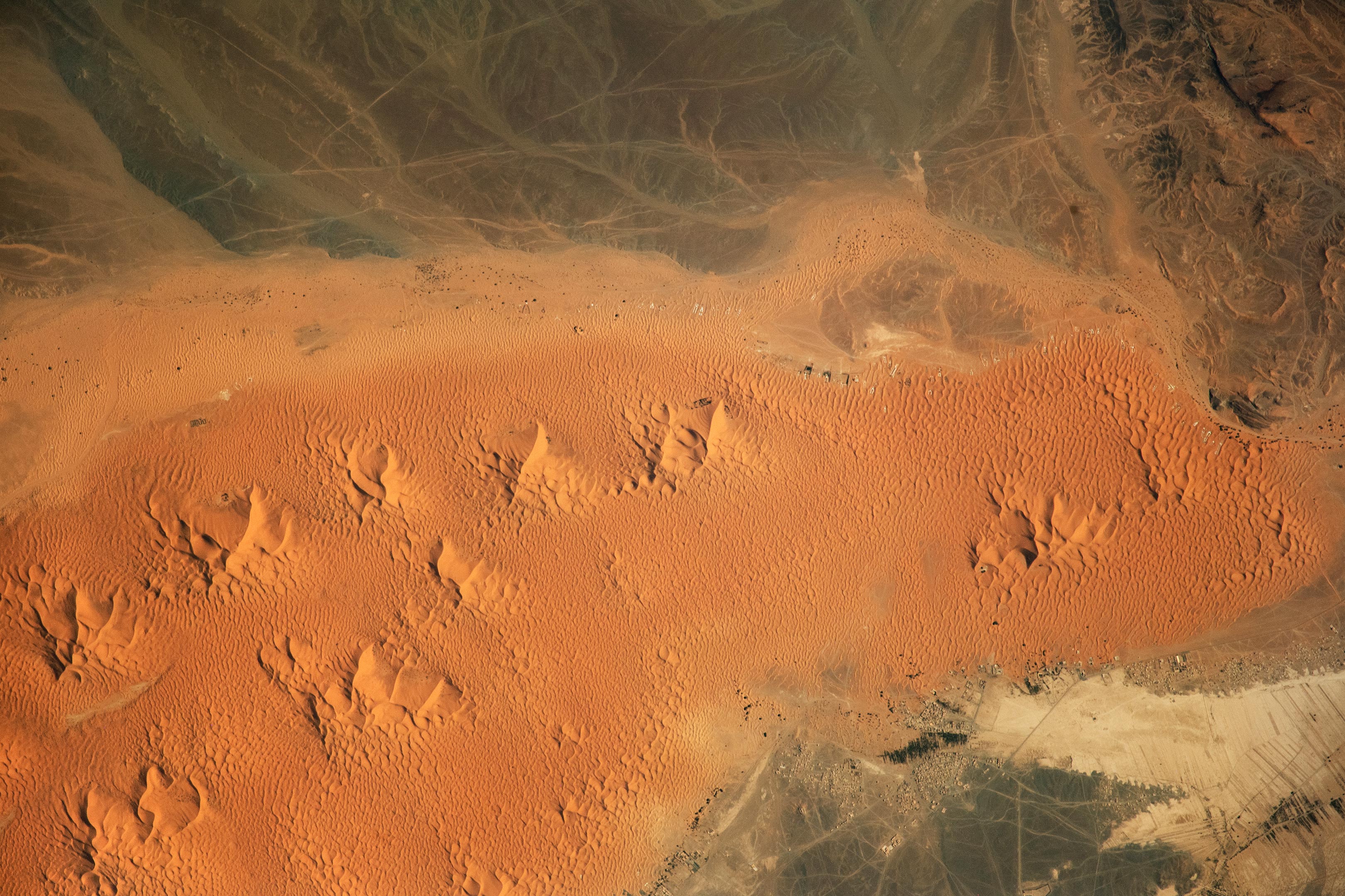
A striking image taken from the International Space Station reveals the Erg Chebbi dunes in southeastern Morocco, part of the vast Sahara Desert.
These dunes, formed by persistent winds, exhibit unique shapes, including star dunes, or pyramid dunes, that rise dramatically against the landscape.
Capturing the Sahara From Space
An astronaut on the International Space Station (ISS) captured this stunning image while orbiting over northern Africa. The photograph reveals Erg Chebbi, a large dune field in southeastern Morocco near the Algerian border and northeast of the Little Atlas mountains. This expansive windswept sandy area, or “erg,” is part of the northwestern Sahara Desert.
Dunes like those in Erg Chebbi form when the wind moves and deposits fine sand, creating mounds of sediment. The dunes in the image show smooth slopes called slip faces, where sand slides down from the crest. On the opposite side, the windward side, the wind carries sand upward, adding height to the dune as long as enough sediment and wind are available. Prominent dunes in the center of the photo have sharp, branching ridges and are known as star dunes, or pyramid dunes—an iconic feature of the Sahara Desert landscape.
Life Amidst the Desert
The town of Marzouga and nearby communities appear at the bottom right of the image. A large, natural aquifer supports palm groves as well as crops in this arid region. Agricultural fields are the long linear features visible in the image’s bottom right corner.
Tourism provides an additional source of income for the communities due to their proximity to the Erg Chebbi dunes. Road lines, mainly created by off-road vehicles, are visible at the top of the image. Tent camps are located on the east side of the dune field, visible from space as small clusters of light-colored rectangular shapes. These camps are mostly used by tourists, though some of them could represent settlements of the Indigenous Amazigh (Berber) peoples.
Astronaut photograph ISS070-E-105480 was acquired on December 21, 2023, with a Nikon D5 digital camera using a focal length of 1,200 millimeters. It is provided by the ISS Crew Earth Observations Facility and the Earth Science and Remote Sensing Unit at Johnson Space Center. The image was taken by a member of the Expedition 70 crew. The image has been cropped and enhanced to improve contrast, and lens artifacts have been removed. The International Space Station Program supports the laboratory as part of the ISS National Lab to help astronauts take pictures of Earth that will be of the greatest value to scientists and the public, and to make those images freely available on the Internet.
Never miss a breakthrough: Join the SciTechDaily newsletter.
Follow us on Google and Google News.
2 Comments
Great work of ISS crew to capture dunes in Erg Chennai,Morocco
Wonderful.
It’s Erg Chebbi and not Chennai