
Close Menu
    Facebook X (Twitter) Instagram
    SciTechDaily
    • Biology
    • Chemistry
    • Earth
    • Health
    • Physics
    • Science
    • Space
    • Technology
    Facebook X (Twitter) Pinterest YouTube RSS
    SciTechDaily
    Home»Space»NASA’s Curiosity Rover Nearing Yellowknife Bay
    Space

    NASA’s Curiosity Rover Nearing Yellowknife Bay

    By Guy Webster, Jet Propulsion LaboratoryDecember 12, 2012No Comments4 Mins Read
    Facebook Twitter Pinterest Telegram LinkedIn WhatsApp Email Reddit
    Share
    Facebook Twitter LinkedIn Pinterest Telegram Email Reddit
    Curiosity Nearing Yellowknife Bay
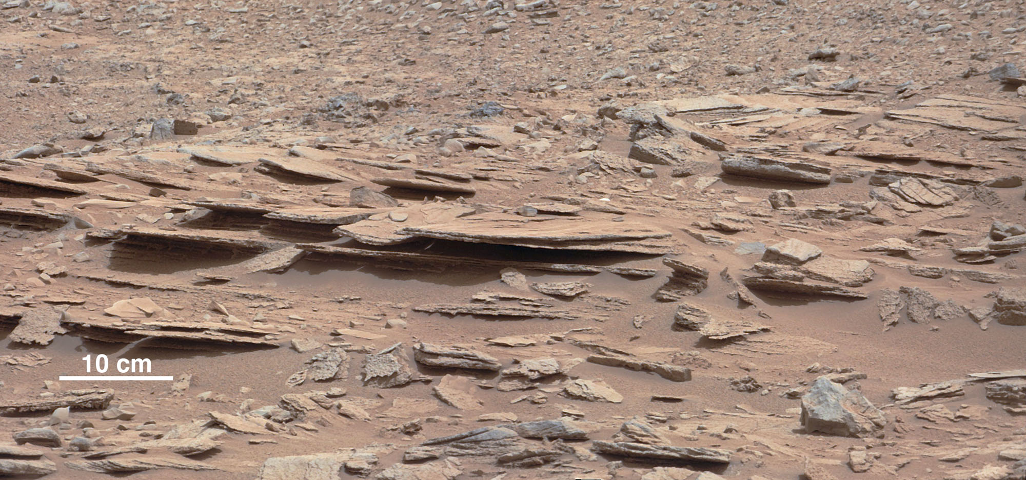
    The NASA Mars rover Curiosity used its Mast Camera (Mastcam) during the mission’s 120th Martian day, or sol (December 7, 2012), to record this view of a rock outcrop informally named “Shaler.” The outcrop’s striking layers, some at angles to each other in a pattern called crossbedding, made it a target of interest for the mission’s science team. The site is near where three types of terrain meet at a place called “Glenelg,” inside Gale Crater. The area covered by the image spans about 3 feet (90 centimeters) in the foreground. The figure includes a 10-centimeter (4-inch) scale bar. The image has been white-balanced to show what the rock would look like if it were on Earth. Credit: NASA/JPL-Caltech/MSSS
    The outcrop’s striking layers, some at angles to each other in a pattern called crossbedding, made it a target of interest for the mission’s science team. The site is near where three types of terrain meet at a place called “Glenelg,” inside Gale Crater.
    The area covered by the image spans about 3 feet (90 centimeters) in the foreground. Figure 1 includes a 10-centimeter (4-inch) scale bar.
    The image has been white-balanced to show what the rock would look like if it were on Earth.

    NASA’s Curiosity rover continues to explore the Martian surface, approaching an area called “Yellowknife Bay,” which is a potential location for selecting the first target rock for Curiosity’s hammering drill, bringing the mission’s total driving distance to 598 meters.

    The NASA Mars rover Curiosity drove 63 feet (19 meters) northeastward early Monday, December 10, approaching a step down into a slightly lower area called “Yellowknife Bay,” where researchers intend to choose a rock to drill.

    The drive was Curiosity’s fourth consecutive driving day since leaving a site near an outcrop called “Point Lake,” where it arrived last month. These drives totaled 260 feet (79 meters) and brought the mission’s total odometry to 0.37 mile (598 meters).

    The route took the rover close to an outcrop called “Shaler,” where scientists used Curiosity’s Chemistry and Camera (ChemCam) instrument and Mast Camera (Mastcam) to assess the rock’s composition and observe its layering. Before departure from Point Lake, a fourth sample of dusty sand that the rover had been carrying from the “Rocknest” drift was ingested and analyzed by Curiosity’s Sample Analysis at Mars (SAM) instrument.
    map traces where NASA's Mars rover Curiosity drove
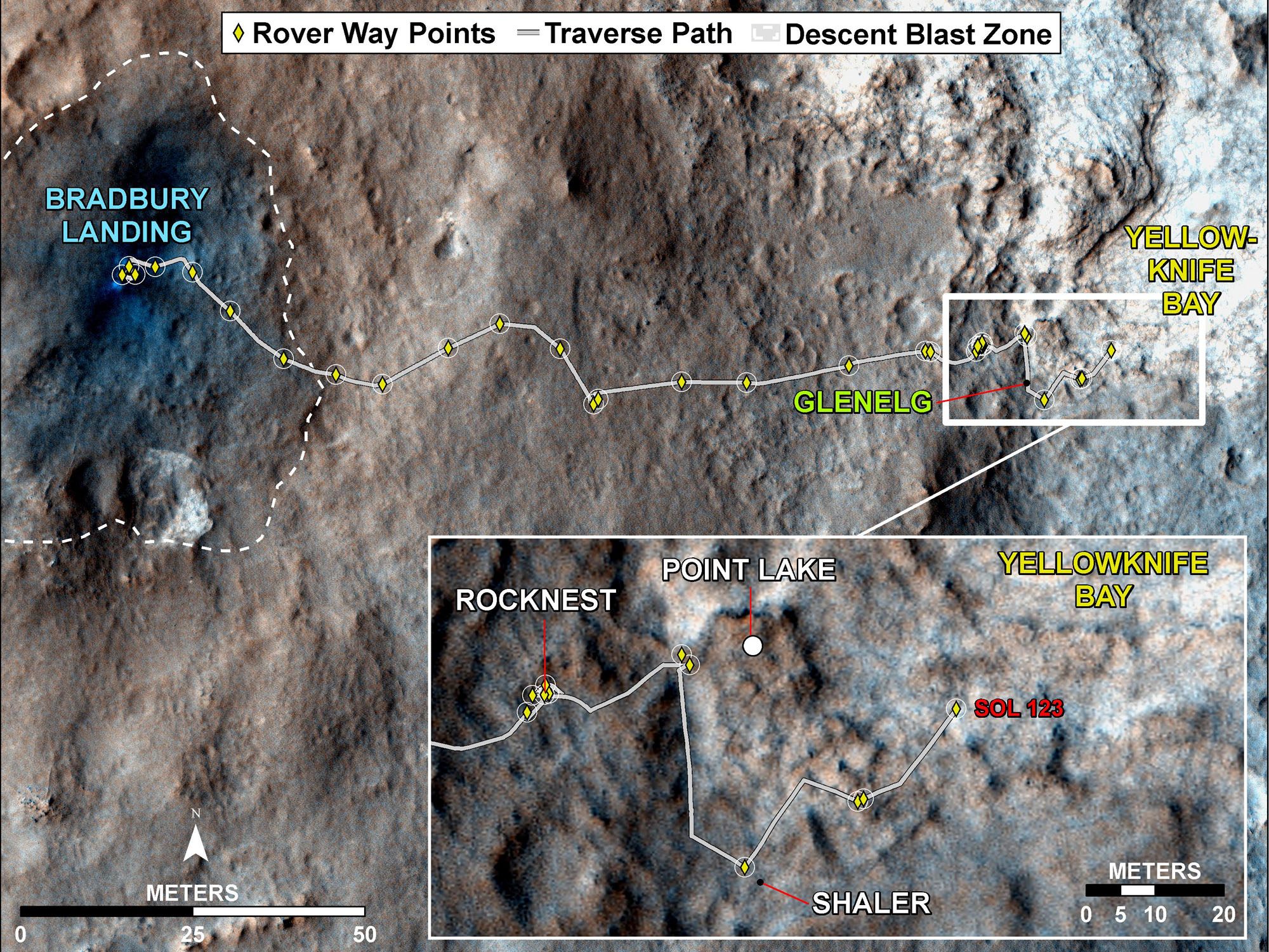
    This map traces where NASA’s Mars rover Curiosity drove between landing at a site subsequently named “Bradbury Landing,” and the position reached during the mission’s 123rd Martian day, or sol, (August 10, 2012). The inset shows the most recent legs of the traverse in greater detail. With the Sol 123 drive of 63 feet (19 meters), the rover approached a step down into an area called “Yellowknife Bay,” which is a potential location for selecting the first target rock for Curiosity’s hammering drill. The drive brought the mission’s total driving odometry to 0.37 mile (598 meters). Three sols earlier, Curiosity stopped near a layered outcrop informally named “Shaler.” The mapped area is within Gale Crater and north of the mountain called Mount Sharp in the middle of the crater. After the first use of the drill, the rover’s main science destination will be on the lower reaches of Mount Sharp. The base image from the map is from the High Resolution Imaging Science Experiment Camera (HiRISE) in NASA’s Mars Reconnaissance Orbiter. Credit: NASA/JPL-Caltech/University of Arizona

    Curiosity ended Monday’s drive about 30 percent shorter than planned for the day when it detected a slight difference between two calculations of its tilt, not an immediate risk, but a trigger for software to halt the drive as a precaution. “The rover is traversing across terrain different from where it has driven earlier, and responding differently,” said Rick Welch, mission manager at NASA’s Jet Propulsion Laboratory, Pasadena, California. “We’re making progress, though we’re still in the learning phase with this rover, going a little slower on this terrain than we might wish we could.”

    Curiosity is approaching a lip where it will descend about 20 inches (half a meter) to Yellowknife Bay. The rover team is checking carefully for a safe way down. Yellowknife Bay is the temporary destination for first use of Curiosity’s rock-powdering drill, before the mission turns southwestward for driving to its main destination on the slope of Mount Sharp.

    JPL, a division of the California Institute of Technology, Pasadena, manages the Mars Science Laboratory Project and the mission’s Curiosity rover for NASA’s Science Mission Directorate, Washington. JPL designed and built the rover.

    Never miss a breakthrough: Join the SciTechDaily newsletter.
    Follow us on Google and Google News.

    Curiosity Rover JPL Mars NASA Planetary Science
    Share. Facebook Twitter Pinterest LinkedIn Email Reddit

    Related Articles

    Mars Rock Is a Close Match in Chemical Composition to Rocks Found on Earth

    Curiosity Prepares to Take Its First Scoop of Soil for Analysis

    Curiosity Finds Ancient Streambed on Mars

    NASA’s Curiosity Prepares for Use of Its Arm and Tools

    Curiosity Sends Back Radioed Words and New Telephoto View of Mars

    NASA’s Curiosity Readies for First Drive on Mars

    Color HiRISE Image of Curiosity Rover on Mars

    First 360-Degree Color Panorama From NASA’s Curiosity Mars Rover

    First Full-Resolution Images From Curiosity’s Navigation Cameras

    Leave A Reply Cancel Reply

    • Facebook
    • Twitter
    • Pinterest
    • YouTube

    Don't Miss a Discovery

    Subscribe for the Latest in Science & Tech!

    Trending News

    Long COVID Brain Scans Reveal Damage to Dopamine Neurons

    Scientists Warn a Silent Oxygen Crisis Is Spreading Through Earth’s Waters

    James Webb Telescope Discovers Hidden Giant Planet in Famous Star System

    Scientists Build the First 3D Cloak That Makes Objects Invisible To Heat

    Common Food Additive Linked To Gut Inflammation

    Black Hole Collisions May Follow a Surprisingly Simple Rule

    The Eye Has a Hidden Cleanup System and Scientists Just Discovered It

    The Truth About Vikings Is More Complicated Than Museums Admit

    Follow SciTechDaily
    • Facebook
    • Twitter
    • YouTube
    • Pinterest
    • Newsletter
    • RSS
    SciTech News
    • Biology News
    • Chemistry News
    • Earth News
    • Health News
    • Physics News
    • Science News
    • Space News
    • Technology News
    Recent Posts
    • A Rare and Deadly Cancer May Have an Unexpected New Vulnerability
    • Sleep Disorders Don’t Just Exhaust You. New Research Shows They Change Your Brain
    • THC-CBD Treatment Dramatically Reduces Agitation in Dementia Trial
    • Rare 8,000-Year-Old Rock Shelter Captures a Turning Point in Human History
    • The Lost “Golden Age” of Human Language
    Copyright © 1998 - 2026 SciTechDaily. All Rights Reserved.
    • Science News
    • About
    • Contact
    • Editorial Board
    • Privacy Policy
    • Terms of Use

    Type above and press Enter to search. Press Esc to cancel.