
Close Menu
    Facebook X (Twitter) Instagram
    SciTechDaily
    • Biology
    • Chemistry
    • Earth
    • Health
    • Physics
    • Science
    • Space
    • Technology
    Facebook X (Twitter) Pinterest YouTube RSS
    SciTechDaily
    Home»Earth»Breathtaking View of Andros, Bahamas From Space [Video]
    Earth

    Breathtaking View of Andros, Bahamas From Space [Video]

    By ESA - European Space AgencyMarch 1, 2020No Comments2 Mins Read
    Facebook Twitter Pinterest Telegram LinkedIn WhatsApp Email Reddit
    Share
    Facebook Twitter LinkedIn Pinterest Telegram Email Reddit
    Andros Bahamas From Space
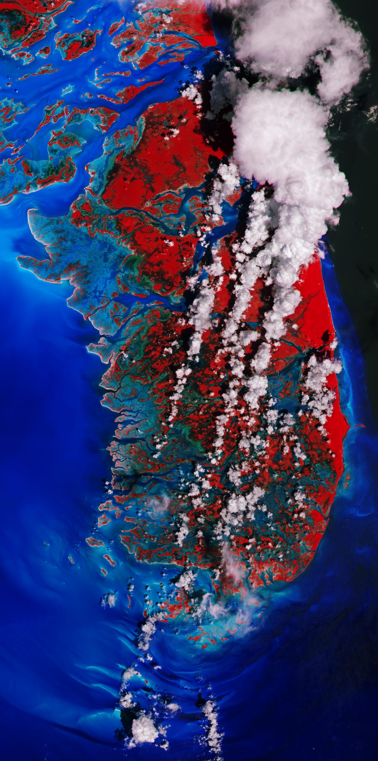
    (Click image for full view.) This false-color image captured by the Copernicus Sentinel-2 mission features Andros Island, the largest island of the Bahamas. This image was processed in a way that included the near-infrared channel, which highlights the island’s vegetation in bright red. Credit: Contains modified Copernicus Sentinel data (2019), processed by ESA, CC BY-SA 3.0 IGO

    Andros Island, the largest island of the Bahamas, is featured in this false-color image captured by the Copernicus Sentinel-2 mission. This image was processed in a way that included the near-infrared channel, which highlights the island’s vegetation in bright red.

    Andros is around 160 km (99 mi) from north to south, and 70 km (43 mi) from east to west at its widest point. The island is largely unpopulated and has undeveloped stretches of land. Even though it is considered a single island, Andros is an archipelago made up of hundreds of small islets and cays connected by estuaries and swamplands together with three major islands: North Andros, Mangrove Cay, and South Andros.

    The island’s west coast features many bays, channels, and inlets. The turquoise colors of the ocean show shallow waters, whereas the dark blue colors are the deep ocean.

    The West Side National Park covers the west part of Andros and includes its pristine coastal wetlands. The 6,000 sq km (2,300 sq mi) park is the largest protected area in the region, and is a prime habitat for bonefish and an important feeding area for the endangered West Indian flamingo.

    This image was acquired on September 5, 2019, just days after the mighty Hurricane Dorian passed over the Bahamas and unleashed a siege of destruction. Dorian is reported to be one of the most powerful Atlantic hurricanes on record – with storm surges, wind, and rain that claimed many lives, destroyed homes, and left thousands of people homeless.

    Compared to acquisitions captured in the days leading up to Hurricane Dorian making landfall, the area in the top-left of the image appears to be more flooded owing to heavy rainfall, and several submerged islands can be seen.

    In response to Hurricane Dorian, the Copernicus Emergency Mapping Service was activated. The service uses observations from several Earth observation satellites, such as Copernicus Sentinel-1 and-2, to provide flood, risk and recovery maps.

    Never miss a breakthrough: Join the SciTechDaily newsletter.
    Follow us on Google and Google News.

    European Space Agency Geography
    Share. Facebook Twitter Pinterest LinkedIn Email Reddit

    Related Articles

    Earth From Space: Magnificent Canadian Arctic Archipelago

    Stunning Views of Houston Texas From Copernicus Sentinel-1 Satellite

    Earth From Space: Bolivian Highland Heart [Video]

    Flevoland, Netherlands From Space: One of the Largest Land Reclamation Projects in the World

    Earth From Space: Lake George, Uganda – A Center for Biological Diversity [Video]

    Deforestation in Bolivia Spied From Space Satellite

    Earth From Space: Japanese Archipelago [Video]

    Earth From Space: Faroe Islands [Video]

    Earth From Space: Tromsø, Norway [Video]

    Leave A Reply Cancel Reply

    • Facebook
    • Twitter
    • Pinterest
    • YouTube

    Don't Miss a Discovery

    Subscribe for the Latest in Science & Tech!

    Trending News

    NASA’s Voyager 1 Is About to Become the First Spacecraft One Light-Day From Earth

    A Woman Who Lived 30,000 Years Ago Is Changing What We Know About Ice Age Europe

    A Rare Radioactive Element Reveals a Hidden Secret About the Heaviest Atoms

    Breakthrough Cancer Treatment Wipes Out Deadly Brain Tumors in Every Mouse Tested

    Something Remarkable Is Happening to Dogs Living Near Chernobyl’s Nuclear Plant

    Hubble Uncovers a Mysterious 93-Billion-Mile Structure Hiding in a Nearby Star System

    Earth’s Oceans Were Slowly Suffocating Millions of Years Before a Devastating Mass Extinction

    Why Are Men Twice As Likely To Develop Parkinson’s? Scientists Discover a Hidden Clue in the Brain

    Follow SciTechDaily
    • Facebook
    • Twitter
    • YouTube
    • Pinterest
    • Newsletter
    • RSS
    SciTech News
    • Biology News
    • Chemistry News
    • Earth News
    • Health News
    • Physics News
    • Science News
    • Space News
    • Technology News
    Recent Posts
    • A Healthier Form of Salt Could Prevent Nearly 3 Million Deaths Every Year, Scientists Say
    • Scientists Engineer Rice That Fights Back Against a Devastating Crop Disease
    • Deep-Sea Scientists Capture Extraordinary 4K Footage of a Fish With a See-Through Head
    • Scientists Find That Older Brains React Very Differently to a Night of Poor Sleep
    • A Hidden Substance in Drinking Water May Be Linked to Heart Problems in Children
    Copyright © 1998 - 2026 SciTechDaily. All Rights Reserved.
    • Science News
    • About
    • Contact
    • Editorial Board
    • Privacy Policy
    • Terms of Use

    Type above and press Enter to search. Press Esc to cancel.