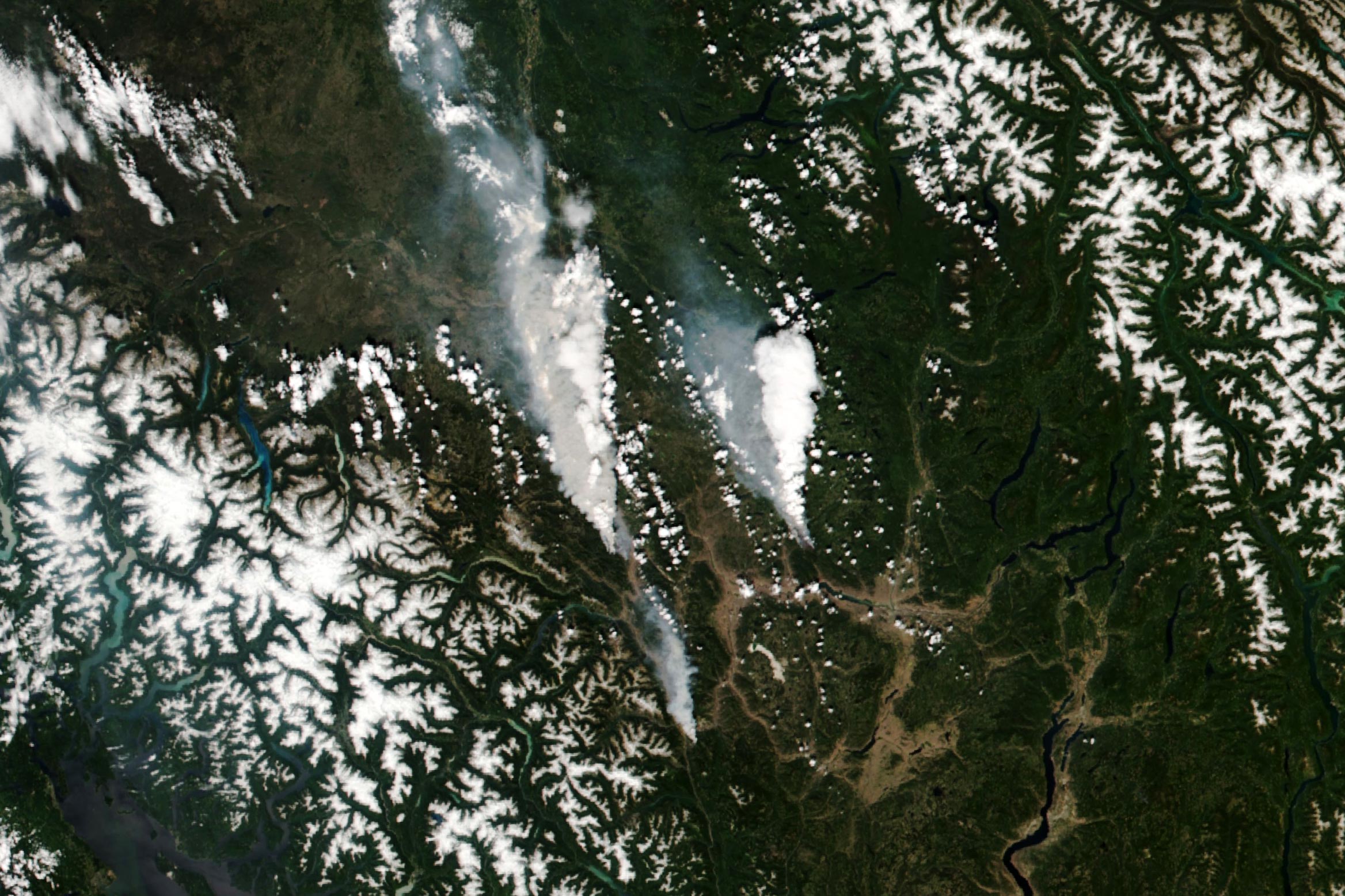
More than 40 wildfires were burning across the Canadian province by the end of June 2021, including a cluster of substantial blazes located about 200 kilometers northeast of Vancouver.
So far in 2021, British Columbia has already seen dangerous wildfires and heat. More than 40 wildfires were burning across the Canadian province by the end of June 2021, including a cluster of substantial blazes located about 200 kilometers northeast of Vancouver.
The Visible Infrared Imaging Radiometer Suite (VIIRS) on the NOAA-20 satellite acquired this image (above) around 2 p.m. local time (21:00 Universal Time) on June 30, 2021. By the morning of July 1, the McKay Creek fire (left) and the Sparks Lake fire (right) had burned an estimated 150 and 200 square kilometers (60 and 75 square miles), respectively. A smaller fire is visible just south of the town of Lytton.
Notice the bright white areas over the two larger fires. According to Michael Fromm, a meteorologist with the Naval Research Laboratory, these are the onset of pyrocumulonimbus (pyroCb) clouds—towering clouds created by the convection and heat rising from a fire. The clouds are a mixture of brown smoke and white ice, so they show up whiter than the dry smoke plumes to the west of each fire.
The second image (below) shows a detailed view of the McKay Creek fire, acquired by the Operational Land Imager (OLI) on Landsat 8 at about 12 p.m. local time (19:00 Universal Time) on June 30, 2021. The natural-color image was overlaid with shortwave-infrared light to highlight the active fire.
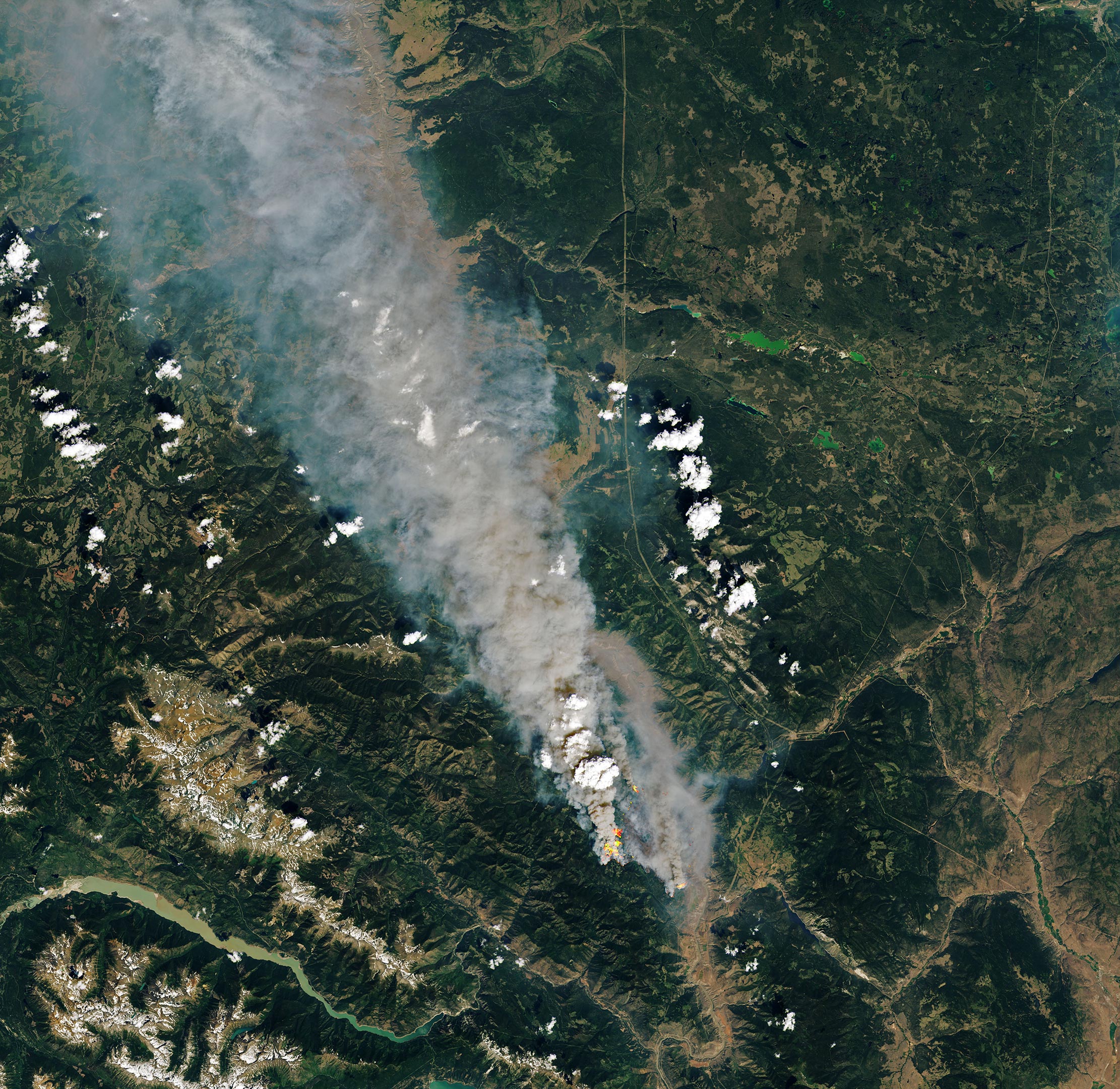
Hours after these images were acquired, officials ordered a mandatory evacuation for Lytton as fire threatened the town. According to news reports, the fast-moving blaze quickly engulfed the town, destroying homes and injuring residents. The fire affecting Lytton was reportedly a new fire, and not the George Road fire already burning south of the town.
The spate of fires has occurred during a streak of record-setting temperatures across the Pacific Northwest and western Canada. On June 29, 2021, Lytton hit 121°F (49.6°C)—the highest temperature on record anywhere in the country on any date.
“The forests are vulnerable each summer, and big fires and pyroCbs have been seen there repeatedly,” Fromm said. “But there’s no doubt the extreme heat and substantial wind exacerbate the fire danger.”
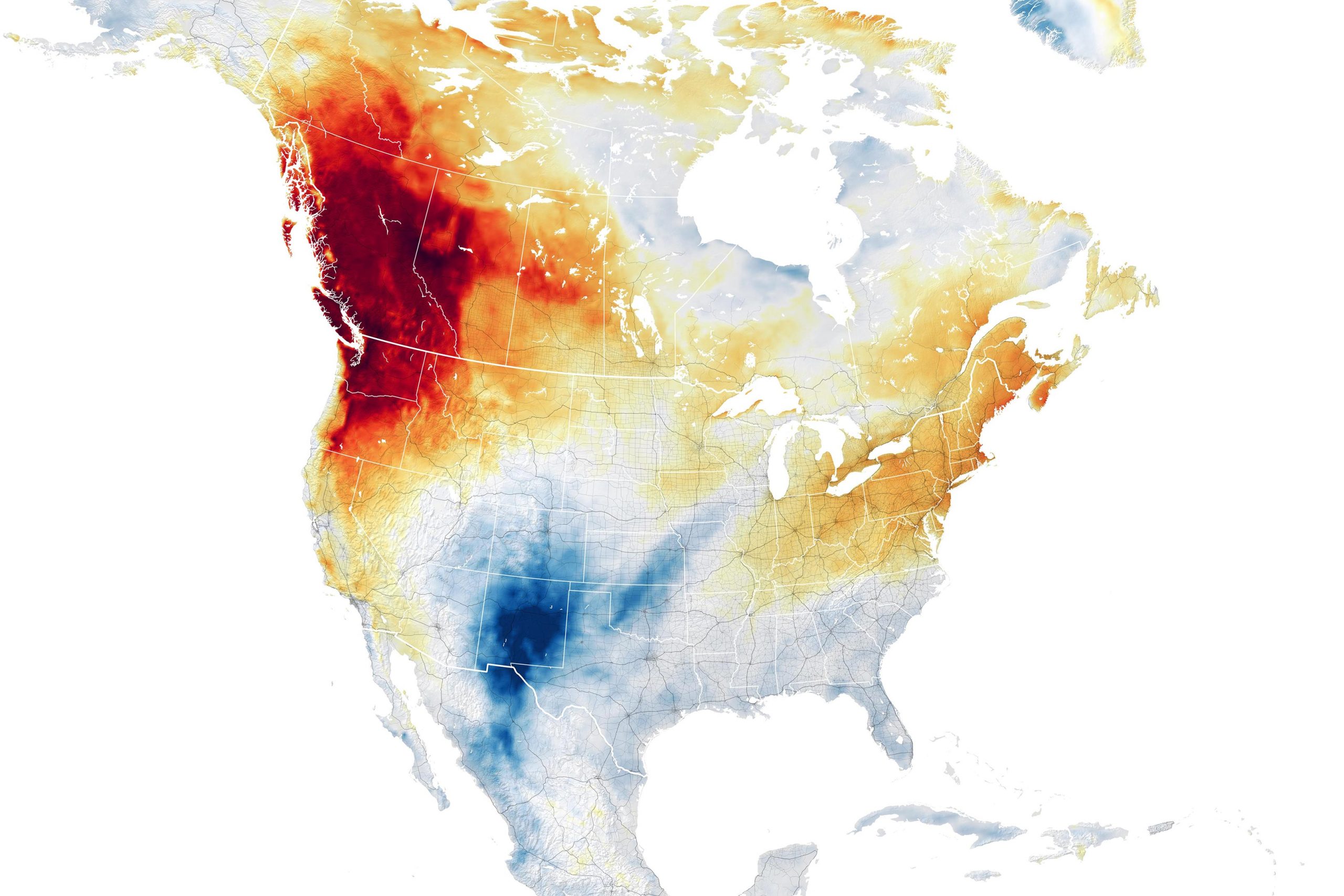
The map above shows air temperature anomalies across the western United States and Canada on June 29, 2021. The map is derived from the Goddard Earth Observing System (GEOS) model and depicts air temperatures at 2 meters (about 6.5 feet) above the ground. The darkest red areas are where air temperatures were 36°F (20°C) higher than the 2014-2020 average for the same day.
The GEOS model, like all weather and climate models, uses mathematical equations that represent physical processes (such as precipitation and cloud processes) to calculate what the atmosphere will do. Actual measurements of physical properties, like temperature, moisture, and winds, are routinely folded into the model to keep the simulation as close to observed reality as possible.
NASA Earth Observatory images by Lauren Dauphin and Joshua Stevens, using VIIRS data from NASA EOSDIS LANCE, GIBS/Worldview, and the Suomi National Polar-orbiting Partnership, Landsat data from the U.S. Geological Survey, and GEOS-5 data from the Global Modeling and Assimilation Office at NASA GSFC.
Never miss a breakthrough: Join the SciTechDaily newsletter.
Follow us on Google and Google News.
1 Comment
The forecast high for Lytton, BC, on July 4? 80 degrees.