
New data from NASA’s Curiosity Rover indicate that Mount Sharp on Mars was built by sediments deposited in a large lake bed over tens of millions of years, suggesting ancient Mars maintained a climate that could have produced long-lasting lakes at many locations on the Red Planet.
“If our hypothesis for Mount Sharp holds up, it challenges the notion that warm and wet conditions were transient, local, or only underground on Mars,” said Ashwin Vasavada, Curiosity deputy project scientist at NASA’s Jet Propulsion Laboratory in Pasadena. “A more radical explanation is that Mars’ ancient, thicker atmosphere raised temperatures above freezing globally, but so far we don’t know how the atmosphere did that.”
Why this layered mountain sits in a crater has been a challenging question for researchers. Mount Sharp stands about 3 miles (5 kilometers) tall, its lower flanks exposing hundreds of rock layers. The rock layers – alternating between lake, river, and wind deposits — bear witness to the repeated filling and evaporation of a Martian lake much larger and longer-lasting than any previously examined close-up.
“We are making headway in solving the mystery of Mount Sharp,” said Curiosity Project Scientist John Grotzinger of the California Institute of Technology in Pasadena, California. “Where there’s now a mountain, there may have once been a series of lakes.”
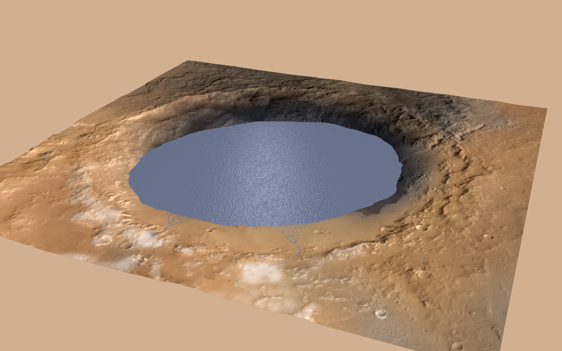
Curiosity currently is investigating the lowest sedimentary layers of Mount Sharp, a section of rock 500 feet (150 meters) high dubbed the Murray formation. Rivers carried sand and silt to the lake, depositing the sediments at the mouth of the river to form deltas similar to those found at river mouths on Earth. This cycle occurred over and over again.
“The great thing about a lake that occurs repeatedly, over and over, is that each time it comes back it is another experiment to tell you how the environment works,” Grotzinger said. “As Curiosity climbs higher on Mount Sharp, we will have a series of experiments to show patterns in how the atmosphere and the water and the sediments interact. We may see how the chemistry changed in the lakes over time. This is a hypothesis supported by what we have observed so far, providing a framework for testing in the coming year.”
After the crater filled to a height of at least a few hundred yards and the sediments hardened into rock, the accumulated layers of sediment were sculpted over time into a mountainous shape by wind erosion that carved away the material between the crater perimeter and what is now the edge of the mountain.
On the 5-mile (8-kilometer) journey from Curiosity’s 2012 landing site to its current work site at the base of Mount Sharp, the rover uncovered clues about the changing shape of the crater floor during the era of lakes.
“We found sedimentary rocks suggestive of small, ancient deltas stacked on top of one another,” said Curiosity science team member Sanjeev Gupta of Imperial College in London. “Curiosity crossed a boundary from an environment dominated by rivers to an environment dominated by lakes.”
Despite earlier evidence from several Mars missions that pointed to wet environments on ancient Mars, modeling of the ancient climate has yet to identify the conditions that could have produced long periods warm enough for stable water on the surface.
NASA’s Mars Science Laboratory Project uses Curiosity to assess ancient, potentially habitable environments and the significant changes the Martian environment has experienced over millions of years. This project is one element of NASA’s ongoing Mars research and preparation for a human mission to the planet in the 2030s.
“Knowledge we’re gaining about Mars’ environmental evolution by deciphering how Mount Sharp formed will also help guide plans for future missions to seek signs of Martian life,” said Michael Meyer, lead scientist for NASA’s Mars Exploration Program at the agency’s headquarters in Washington.
JPL, managed by the California Institute of Technology, built the rover and manages the project for NASA’s Science Mission Directorate in Washington.
Never miss a breakthrough: Join the SciTechDaily newsletter.
Follow us on Google and Google News.
1 Comment
Would be helpful to know the Earths geology and development occurring at the same time as the cyclic filling of this crater, what was the simultaneous geological period(s)