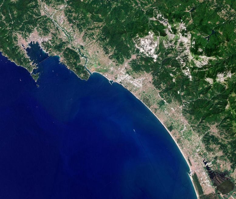
Sentinel-2 satellite image of Carrara, Italy, a city known especially for its world-famous marble. Credit: Contains modified Copernicus Sentinel data (2021), processed by ESA, CC BY-SA 3.0 IGO
The Copernicus Sentinel-2 mission takes us over Carrara – an Italian city known especially for its world-famous marble.
Carrara lies along the Carrione River, in northern Tuscany, around 130 km (80 mi) from Florence. It can be seen just above the center of the image, stretching into the mountains.
The city is famous for its white or blue-grey marble, called Carrara, taken from nearby quarries in the Apuan Alps, a mountain range that stretches for approximately 55 km (34 mi) and reaching around 2000 m (6,6000 ft) high. What appears as snow cover on the rugged mountains is actually bright white marble, contrasting with Tuscany’s lush green vegetation.
Carrara marble is one of the most prestigious marbles in the world, with its quarries producing more marble than any other place on Earth. The unique stone was formed by calcite-rich shells left behind by marine organisms when they die. When water bodies evaporate, the deposited remains form limestone, and when buried under multi-tonne layers of rock, the intense heat and pressure cause the limestone to metamorphose into marble.
The special quality of the Carrara marble has made it a popular resource for many famous sculptures, including Michelangelo’s Pietà, and has been used for some of the most remarkable buildings in Ancient Rome, including the Pantheon and Trajan’s Column.
Also featured in this summery image from Sentinel-2 are the towns of Forte dei Marmi, Pietrasanta, Lido di Camaiore and Viareggio. Marina di Carrara, southwest of the city, is a beach resort on the Ligurian Sea, with port facilities for transporting and shipping marble. The most popular resorts and beaches nearby are those at Marina di Carrara and Marina di Massa, both of which become very crowded during the summer, especially with Italian holidaymakers. La Spezia, a major naval base and the second largest city in the Liguria region, is visible in the top-left of the image.
Copernicus Sentinel-2 is based on a constellation of two identical satellites in the same orbit, 180° apart for optimal coverage and data delivery. Together they cover all Earth’s land surfaces, large islands, inland, and coastal waters every five days at the equator.


Be the first to comment on "Exploring Earth From Space: Carrara, Italy [Video]"