Close Menu
    Facebook X (Twitter) Instagram
    SciTechDaily
    • Biology
    • Chemistry
    • Earth
    • Health
    • Physics
    • Science
    • Space
    • Technology
    Facebook X (Twitter) Pinterest YouTube RSS
    SciTechDaily
    Home»Earth»From Spark to Spectacle: California’s Park Fire Outsizes Los Angeles in Days
    Earth

    From Spark to Spectacle: California’s Park Fire Outsizes Los Angeles in Days

    By NASA Earth Observatory, Lindsey DoermannJuly 30, 2024No Comments3 Mins Read
    Facebook Twitter Pinterest Telegram LinkedIn WhatsApp Email Reddit
    Share
    Facebook Twitter LinkedIn Pinterest Telegram Email Reddit
    Park Fire Natural Color Annotated
    Natural-color satellite image of the Park Fire in Northern California captured on July 27, 2024, Operational Land Imager-2 on Landsat 9.
    Park Fire False Color Annotated
    False-color satellite image of the Park Fire in Northern California captured on July 27, 2024, Operational Land Imager-2 on Landsat 9.

    The Northern California blaze expanded at lightning speed amid record heat and high winds, leaving behind a vast burned area.

    The Park Fire in Northern California expanded to 370,000 acres by late July 2024, aided by record weather conditions, making it the largest active U.S. fire, leading to significant evacuations and park closures despite containment efforts.

    Park Fire Escalation and Initial Impact

    In a matter of days, the Park Fire in Northern California more than doubled in area in late July 2024. It quickly became the state’s seventh-largest wildland fire on record, and as of July 29, it was the largest active fire in the United States.

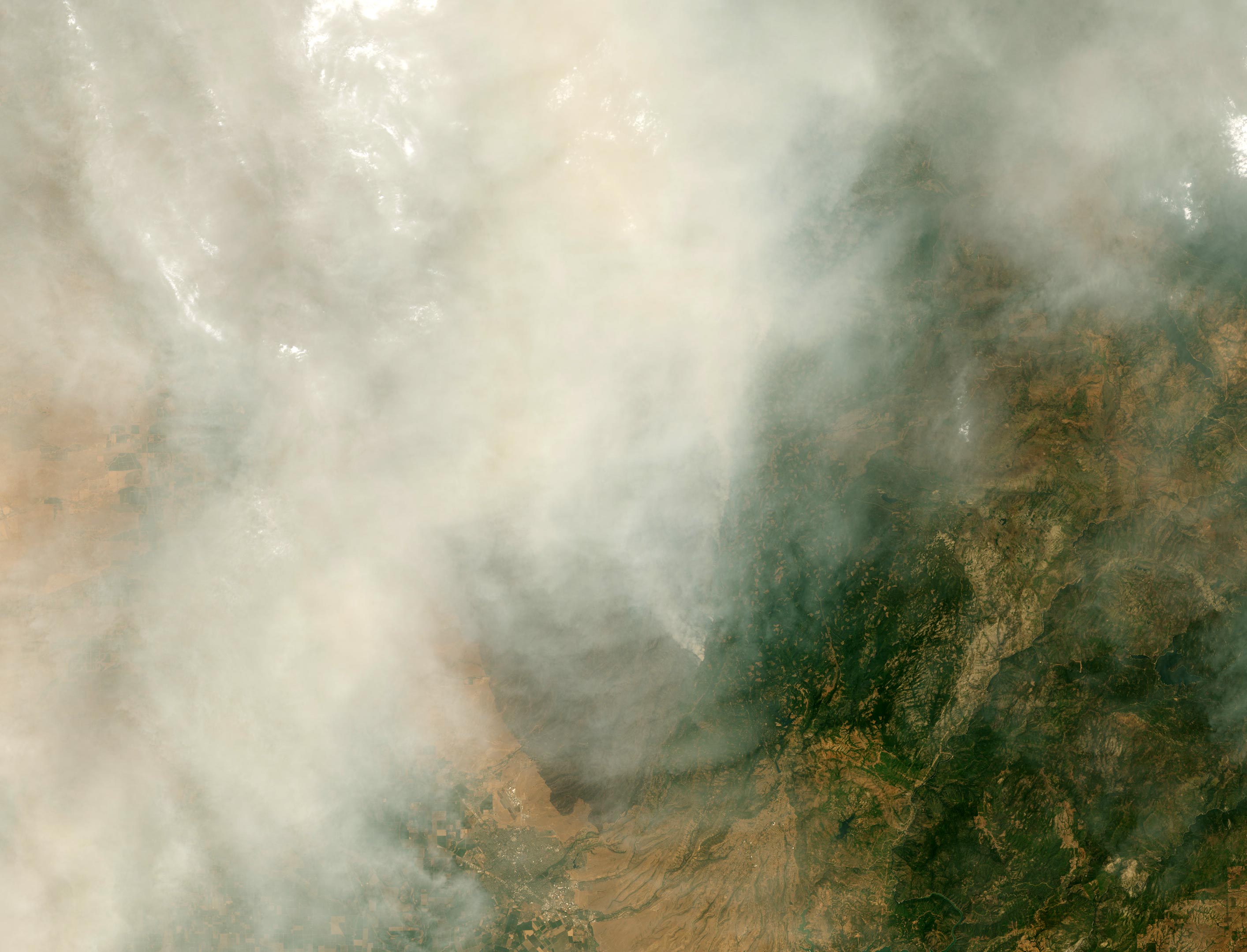
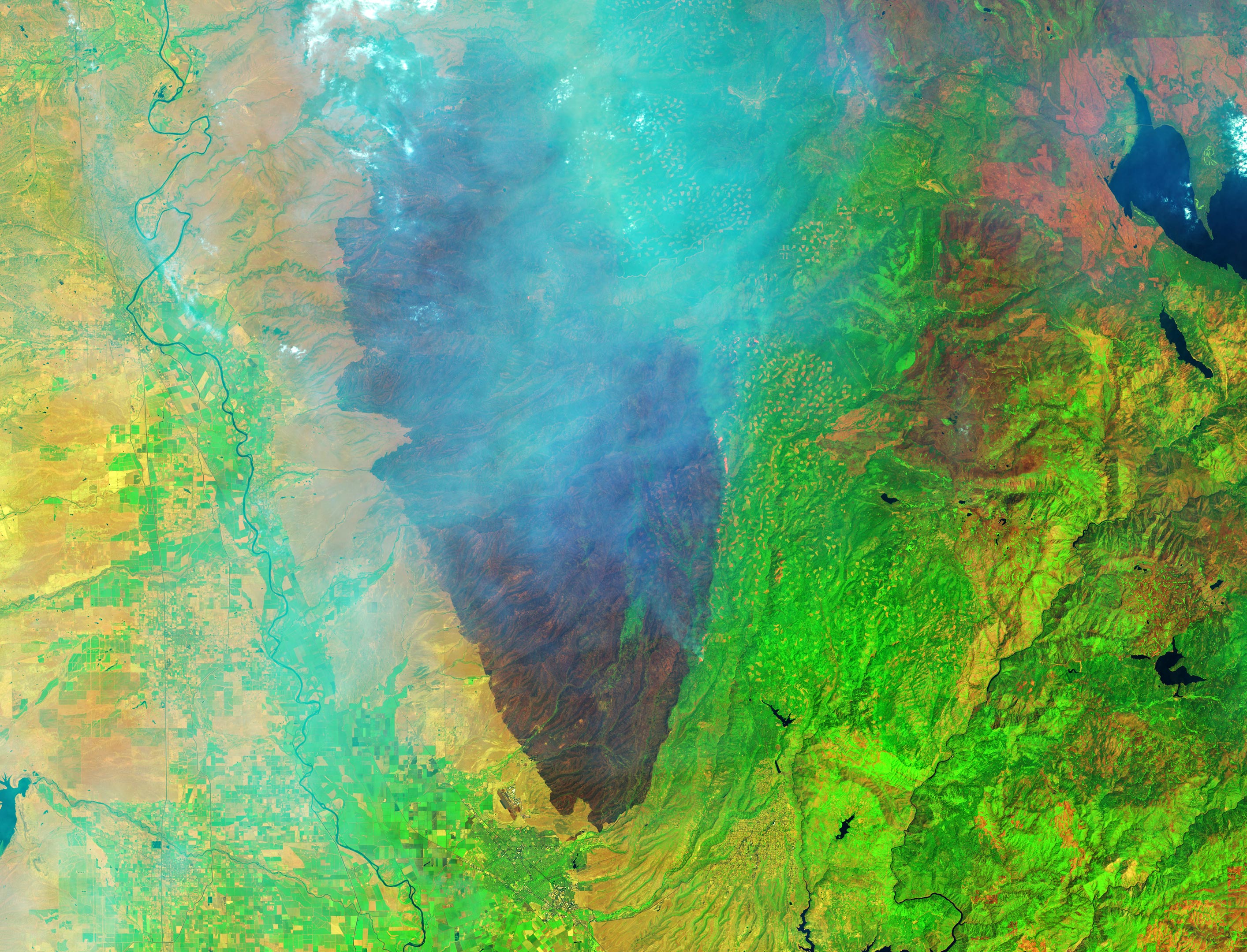
    The OLI-2 (Operational Land Imager-2) on Landsat 9 captured the images above of the Park Fire on July 27. In the natural-color scene (upper), widespread smoke largely obscures the fire’s mark on the land below. The burned area is evident in the false-color image (lower) showing shortwave infrared, near infrared, and visible light (OLI bands 6-5-3). This band combination makes it easier to identify unburned vegetated areas (green) and the recently burned landscape (brown). Thicker areas of the smoke plume appear light blue.

    Park Fire Growth and Remote Sensing Insights

    The Park Fire ignited around 3 p.m. local time on July 24 near Chico, California, and spread rapidly as it consumed dry grass and brush. By the morning of July 26, it had burned 165,000 acres. The next day, when these images were acquired, the burned area had ballooned to 307,000 acres—an area larger than the city of Los Angeles—according to Cal Fire. Record heat, high winds, and abundant dry fuel contributed to the extreme fire behavior and rapid expansion, experts told news sources.

    Periods of cooler temperatures starting the evening of July 27 moderated the fire’s growth and allowed crews to combat the flames. Cal Fire reported that the fire had grown to approximately 370,000 acres on July 29, with 12 percent containment. The blazes prompted evacuation orders in four counties and the closure of public lands, including Lassen Volcanic National Park.

    NASA Earth Observatory images by Wanmei Liang, using Landsat data from the U.S. Geological Survey.

    Never miss a breakthrough: Join the SciTechDaily newsletter.
    Follow us on Google and Google News.

    NASA Earth Observatory Wildfires
    Share. Facebook Twitter Pinterest LinkedIn Email Reddit

    Related Articles

    Massive Clouds of Smoke From California Wildfires Blow Over the Pacific Ocean

    Relentless Wildfires Across Northern California Leave Vast Burn Scars

    Wildfires Rage – Smoke Continues to Spread Across the U.S. West

    Smoke Shrouds the U.S. West After More Than 10,000 Lightning Strikes Ignite Hundreds of Wildfires Across California

    Thick Smoke Obscures California Skies After Wildfires Exploded Across the North

    NASA/NOAA Satellites Observe Surprisingly Rapid Increase in Scale and Intensity of Fires in Siberia

    Massive Mineral Fire Observed From Space – Burned More Than 28,000 Acres in California

    NASA Satellite Watches as Bush Fire Scorches Land Near Phoenix

    NASA Satellites Spot Several Wildfires Near Chernobyl Exclusion Zone

    Leave A Reply Cancel Reply

    • Facebook
    • Twitter
    • Pinterest
    • YouTube

    Don't Miss a Discovery

    Subscribe for the Latest in Science & Tech!

    Trending News

    Why Popular Diabetes Drugs Like Ozempic Don’t Work for Everyone: The “Genetic Glitch”

    Scientists Stunned After Finding Plant Thought Extinct for 60 Years

    Scientists Discover Tiny New Spider That Hunts Prey 6x Its Size

    Natural Component From Licorice Shows Promise for Treating Inflammatory Bowel Disease

    Scientists Warn: Popular Sweetener Linked to Dangerous Metabolic Effects

    Monster Storms on Jupiter Unleash Lightning Beyond Anything on Earth

    Scientists Create “Liquid Gears” That Spin Without Touching

    The Simple Habit That Could Help Prevent Cancer

    Follow SciTechDaily
    • Facebook
    • Twitter
    • YouTube
    • Pinterest
    • Newsletter
    • RSS
    SciTech News
    • Biology News
    • Chemistry News
    • Earth News
    • Health News
    • Physics News
    • Science News
    • Space News
    • Technology News
    Recent Posts
    • Seeing the Invisible: Scientists Develop New Way To Track Particles in 3D
    • The Atomic Gap That Could Cost the Semiconductor Industry Billions
    • Earth’s Secret Advantage: Why Most Alien Worlds May Be Too Dry for Life
    • Ancient Bacteria Turned a DNA System Into a Cell Skeleton
    • Researchers Finally Solve 50-Year-Old Blood Group Mystery
    Copyright © 1998 - 2026 SciTechDaily. All Rights Reserved.
    • Science News
    • About
    • Contact
    • Editorial Board
    • Privacy Policy
    • Terms of Use

    Type above and press Enter to search. Press Esc to cancel.