The new discovery of a deep canyon buried along the Yarlung Tsangpo River in south Tibet effectively rules out a popular model used to explain how the massive and picturesque gorges of the Himalayas became so steep, so fast.
A team of researchers from Caltech and the China Earthquake Administration has discovered an ancient, deep canyon buried along the Yarlung Tsangpo River in south Tibet, north of the eastern end of the Himalayas. The geologists say that the ancient canyon—thousands of feet deep in places—effectively rules out a popular model used to explain how the massive and picturesque gorges of the Himalayas became so steep, so fast.
“I was extremely surprised when my colleagues, Jing Liu-Zeng and Dirk Scherler, showed me the evidence for this canyon in southern Tibet,” says Jean-Philippe Avouac, the Earle C. Anthony Professor of Geology at Caltech. “When I first saw the data, I said, ‘Wow!’ It was amazing to see that the river once cut quite deeply into the Tibetan Plateau because it does not today. That was a big discovery, in my opinion.”
Geologists like Avouac and his colleagues, who are interested in tectonics—the study of the earth’s surface and the way it changes—can use tools such as GPS and seismology to study crustal deformation that is taking place today. But if they are interested in studying changes that occurred millions of years ago, such tools are not useful because the activity has already happened. In those cases, rivers become a main source of information because they leave behind geomorphic signatures that geologists can interrogate to learn about the way those rivers once interacted with the land—helping them to pin down when the land changed and by how much, for example.
“In tectonics, we are always trying to use rivers to say something about uplift,” Avouac says. “In this case, we used a paleocanyon that was carved by a river. It’s a nice example where by recovering the geometry of the bottom of the canyon, we were able to say how much the range has moved up and when it started moving.”
The team reports its findings in the current issue of Science.
Last year, civil engineers from the China Earthquake Administration collected cores by drilling into the valley floor at five locations along the Yarlung Tsangpo River. Shortly after, former Caltech graduate student Jing Liu-Zeng, who now works for that administration, returned to Caltech as a visiting associate and shared the core data with Avouac and Dirk Scherler, then a postdoc in Avouac’s group. Scherler had previously worked in the far western Himalayas, where the Indus River has cut deeply into the Tibetan Plateau, and immediately recognized that the new data suggested the presence of a paleocanyon.
Liu-Zeng and Scherler analyzed the core data and found that at several locations there were sedimentary conglomerates, rounded gravel, and larger rocks cemented together, that are associated with flowing rivers, until a depth of 800 meters (2,600 feet) or so, at which point the record clearly indicated bedrock. This suggested that the river was once carved deeply into the plateau.
To establish when the river switched from incising bedrock to depositing sediments, they measured two isotopes, beryllium-10 and aluminum-26, in the lowest sediment layer. The isotopes are produced when rocks and sediment are exposed to cosmic rays at the surface and decay at different rates once buried, and so allowed the geologists to determine that the paleocanyon started to fill with sediment about 2.5 million years ago.
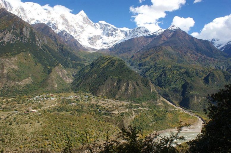
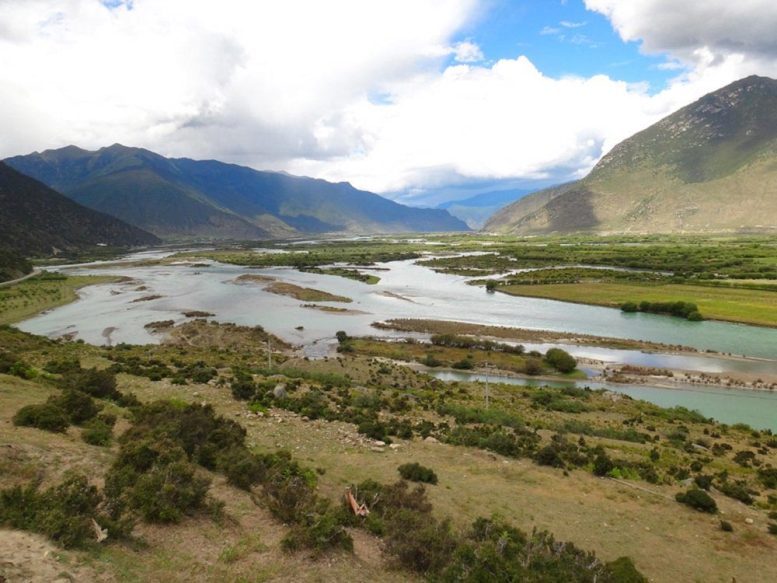
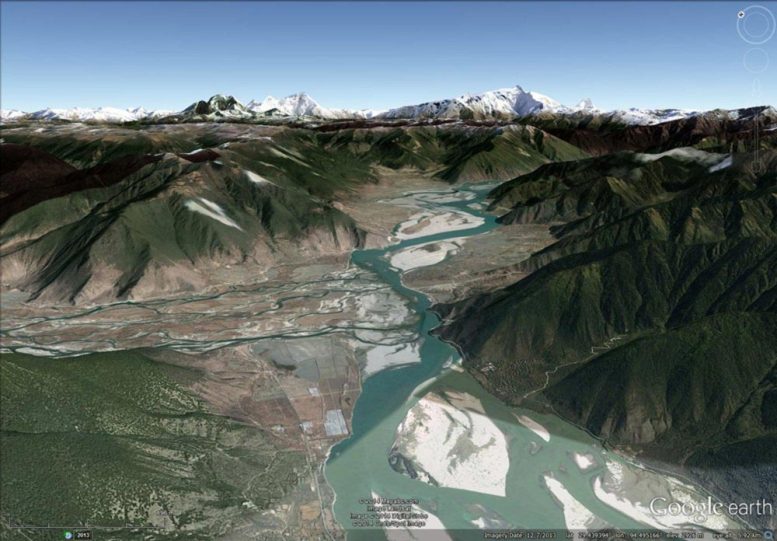
The researchers’ reconstruction of the former valley floor showed that the slope of the river once increased gradually from the Gangetic Plain to the Tibetan Plateau, with no sudden changes, or knickpoints. Today, the river, like most others in the area, has a steep knickpoint where it meets the Himalayas, at a place known as the Namche Barwa massif. There, the uplift of the mountains is extremely rapid (on the order of 1 centimeter per year, whereas in other areas 5 millimeters per year is more typical) and the river drops by 2 kilometers (1.2 miles) in elevation as it flows through the famous Tsangpo Gorge, known by some as the Yarlung Tsangpo Grand Canyon because it is so deep and long.
Combining the depth and age of the paleocanyon with the geometry of the valley, the geologists surmised that the river existed in this location prior to about 3 million years ago, but at that time, it was not affected by the Himalayas. However, as the Indian and Eurasian plates continued to collide and the mountain range pushed northward, it began impinging on the river. Suddenly, about 2.5 million years ago, a rapidly uplifting section of the mountain range got in the river’s way, damming it, and the canyon subsequently filled with sediment.
“This is the time when the Namche Barwa massif started to rise, and the gorge developed,” says Scherler, one of two lead authors on the paper and now at the GFZ German Research Center for Geosciences in Potsdam, Germany.
That picture of the river and the Tibetan Plateau, which involves the river incising deeply into the plateau millions of years ago, differs quite a bit from the typically accepted geologic vision. Typically, geologists believe that when rivers start to incise into a plateau, they eat at the edges, slowly making their way into the plateau over time. However, the rivers flowing across the Himalayas all have strong knickpoints and have not incised much at all into the Tibetan Plateau. Therefore, the thought has been that the rapid uplift of the Himalayas has pushed the rivers back, effectively pinning them, so that they have not been able to make their way into the plateau. But that explanation does not work with the newly discovered paleocanyon.
The team’s new hypothesis also rules out a model that has been around for about 15 years, called tectonic aneurysm, which suggests that the rapid uplift seen at the Namche Barwa massif was triggered by intense river incision. In tectonic aneurysm, a river cuts down through the earth’s crust so fast that it causes the crust to heat up, making a nearby mountain range weaker and facilitating uplift.
The model is popular among geologists, and indeed Avouac himself published a modeling paper in 1996 that showed the viability of the mechanism. “But now we have discovered that the river was able to cut into the plateau way before the uplift happened,” Avouac says, “and this shows that the tectonic aneurysm model was actually not at work here. The rapid uplift is not a response to river incision.”
The other lead author on the paper, “Tectonic control of Yarlung Tsangpo Gorge revealed by a buried canyon in Southern Tibet,” is Ping Wang of the State Key Laboratory of Earthquake Dynamics, in Beijing, China. Additional authors include Jürgen Mey, of the University of Potsdam, in Germany; and Yunda Zhang and Dingguo Shi of the Chengdu Engineering Corporation, in China. The work was supported by the National Natural Science Foundation of China, the State Key Laboratory for Earthquake Dynamics, and the Alexander von Humboldt Foundation.
Reference: “Tectonic control of Yarlung Tsangpo Gorge revealed by a buried canyon in Southern Tibet” by Ping Wang, Dirk Scherler , Jing Liu-Zeng, Jürgen Mey, Jean-Philippe Avouac, Yunda Zhang and Dingguo Shi, 21 November 2014, Science.
DOI: 10.1126/science.1259041
Never miss a breakthrough: Join the SciTechDaily newsletter.
Follow us on Google and Google News.
1 Comment
Himalayas are rather youngest of all the mountains. When Pangea continent was there was a sea called Aegan sea in its place where the pre-Himalayan rivers drained in. This hidden gorge is also a proof of such pre-Himalayan rivers flowing in Tibet draining into the Aegan Sea. Entire Tibet is raised to the level of the roof of the world by tectonic pressure of india plate against the much massive Asia Plate, which ultimately gave rise to the youngest folded mountains called Himalayas. Only aafter Himalayas were formed , do we have Indus, Ganges and Brahmaputra rivers due to the melting of the snow on the peaks of Himalayas.These perennial rivers are much younger and they could not have caused the said gorges. Thank You.