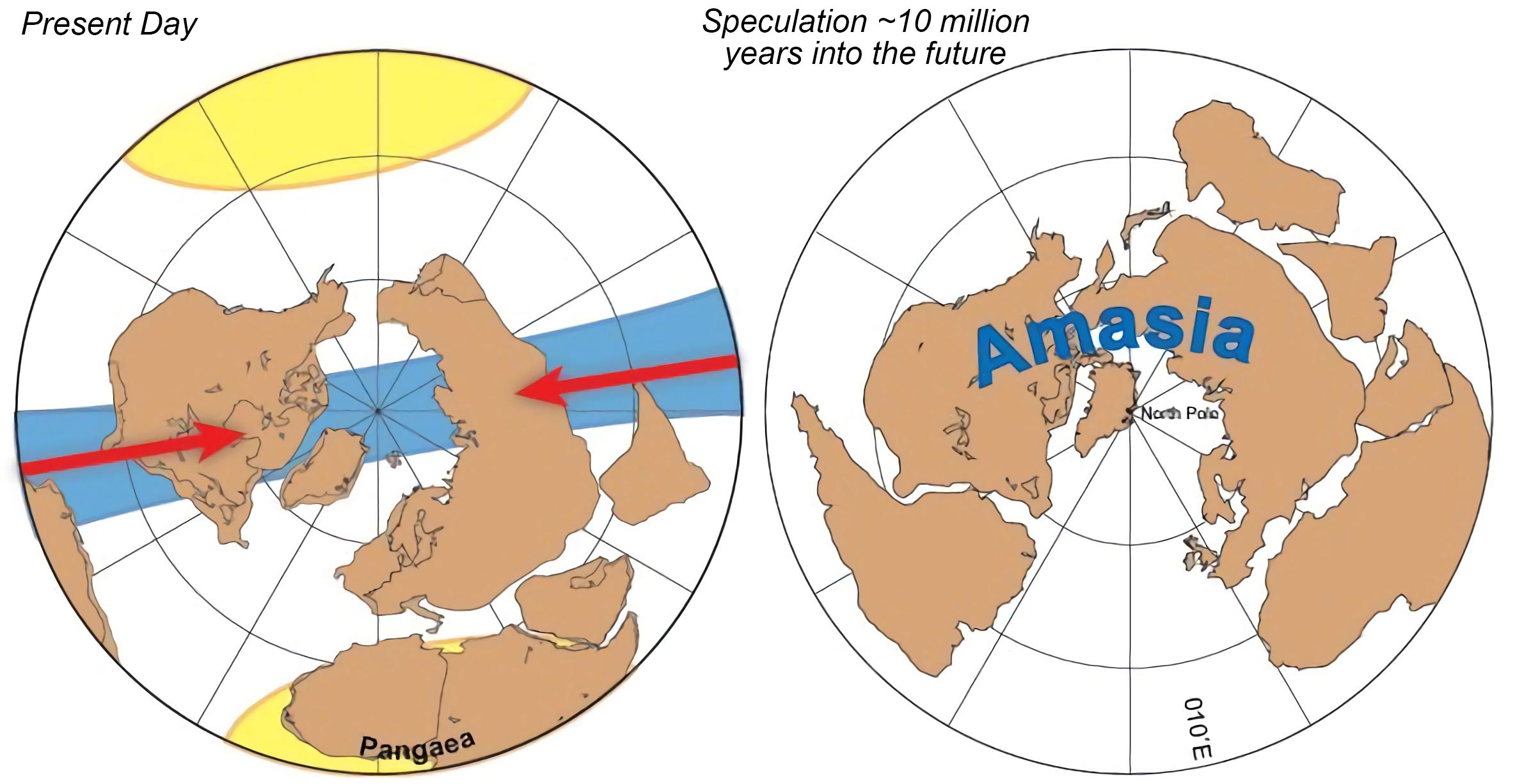
In the next 50 to 200 million years, all of Earth’s continents will be once again pushed together into a single landmass around the North Pole, a supercontinent called Amasia. This conclusion comes from a computer model that has been emulating the slow movements of the continents over the next millions of years.
The last supercontinent was formed 300 million years ago, Pangea, and the land masses were grouped together around the equator. After having examined the geology of the mountain ranges around the world, geologists had previously thought that the next supercontinent would be in the same place as Pangea, it would close up the Atlantic Ocean, or it would be in the middle of the Pacific Ocean.
However, Ross Mitchell, a geologist at Yale University in New Haven, Connecticut, and his colleagues have other ideas. They analyzed the magnetism of ancient rocks to work out their locations on the globe in the past, and measured how the mantle moves the continents that float on its surface. They discovered that instead of staying near the equator, the next supercontinent would form over the Arctic.
Mitchell et al. think that this is part of a pattern since Pangea formed at about 90 degrees to the previous supercontinent Rodinia, and Rodinia at about 90 degrees of Nuna, which existed 2 billion years ago. Amasia would find itself 90 degrees from where Pangea was positioned on the globe.
This new model is called orthoversion, contrary to introversion, where a supercontinent forms exactly where Pangea was, or extroversion, where it moves to the other side of the world but staying on the equator.
Orthoversion clears up a conundrum that has been on geologists’ minds for decades since it models where the next supercontinent will be placed. The other possible future supercontinents were Pangea Ultima and Novopangea.
Never miss a breakthrough: Join the SciTechDaily newsletter.
Follow us on Google and Google News.
5 Comments
Tectonic plate movements on our globe earth, clearly states a northern driven force only since the time of Pangea Super-continent. Indian plate was hurled from its mother Australia northwardly to sail and impinge on Asia continent to form the Great Himalayas.Africa is also closing in on Europe and one day Red Sea will vanish and get a mountain there. If we turn the globe south pole head on we will find mostly oceans and sparse continents. Americas and Europe almost close together at greenland towards arctic. Even the previous version of super continent Rodinia was also north bound. It should be borne in mind that earth rotates west to east causing the land mass to be lopsided north. If the spin were from east to west the story would have been otherwise. Hence formation of Amasia is certain in another 300 milion years as stated in the research. One more small point I want to make here. The smaller landmasses of Australia and others down the south of Pacific plate are bound southwards due to Reaction of impingement of mega plates. Plate tectonics are not confined to Earth alone. It is universal for any heavenly spherical terrestrial planet like Moon, Mars etc. Blowing a sphere like a glass bulb blown is possible only when its core is in a very hot gaseous state. These spherical bodies will also show geo magnetism. Phobos and Deimos of Mars are mere stones like any other asteroids and not a regular satelite like moon with no gaseous core. One interesting axiom is that north pole or south pole of any planet would be a stable plate whatsoever. Thank you and we will welcome Amasia so as to bring together Americans and Asians.
Asia and North America have already collided. The Bering Strait appears to divide North America and Asia, but it’s a contrary. The North American+Eurasian subduction zone is actually in Russia. Officially, the Bering Strait coast of North America is the western edge of the tectonic plate and it is a common myth that the land at the east coast of Russia at the Bering Strait is moving east directly toward Alaska. But the North American plate extends far in Asia; much of east Russia is moving west and was a large island divided from North America by an ironic body of water: the Bering Strait. The large island was carried by the North American plate until the island collided with Asia, just like India. Except this large island was carried by the plate, along with the rest of North America. Just like how Italy was an island that was carried by the African plate, along with the rest of Africa, until the island collided with Europe and like the Himalayas, the Swiss Alps formed. In eastern Asia, the big island collided with Asia along north of the Kamchatka Peninsula, creating a mountain range and a high north-south seismic zone. So unfortunately, the Bering Strait is not closing up from the east and west sides. And from the amount of subduction and uplifting of mountains at the actual collision region, it is clear that if the Bering Strait were in fact the subduction zone, then the two would have already collided. Because the amount of time it took for the mountain range at the actual collision region to form, would had been more than enough time for the Bering Strait to close up. And unfortunately, the Bering Strait hasn’t started closing, even though the big island had already collided with Asia. Unlike Italy and Africa, how now that the island had longer ago* collided with Europe, the Mediterranean Sea between Italy and Africa is now closing up. And the subduction zone, which used to be where the Swiss Alps formed, now extends across beneath the Mediterranean Sea. And Europe is not even moving south, yet the process of the Mediterranean Sea narrowing between Italy and Africa had already begun long ago. But with the Bering Strait, that process hasn’t yet occurred, because the distance between the Bering Strait and the region where a mountain range had formed, is much greater than the distance between the Swiss Alps and the southern coast of Italy. But the mountains where North America and Asia collided are not as tall as the Swiss Alps. And North America is moving at about the exact same rate as Africa, since the motion of both continents is driven by the same source beneath the Mid-Atlantic Ridge. And Eurasian moving east at the same rate, while Europe is not moving south against Africa, the process of the edge of the North American plate and the Eurasian plate moving to the weakest point, the Bering Strait, should be happening at twice the rate of that between Europe and Africa. So other than a greater distance being a key factor to why the Bering Strait isn’t getting any narrower each year, another explanation: the large island collided with Asia far more recently than Italy collided with Europe. The Swiss Alps taller than the mountain range in eastern Asia also support that explanation. The other explanation was the fact that and how in fact, it happened between Europe, Africa and Italy based on the Swiss Alps and professional geologists who confirmed it and some books on geology say it. And maps of the large tectonic plates, including at Google, show that the Eurasian plate and the North American plate meet I eastern Asia and not beneath the Bering Strait.
Australian and Indian plate moves rapidly north and slightly east – and will continue to move in a north (east) direction in the future thus causing volcanic activity (and earthquakes) with the collision of surrounding plates within the circle of fire.
If you look back at the world maps (at decade intervals) you will see how far Australia has moved over 100 years.
plates south of the Pacific’s plate will not move south.
there are very thin plates and there are very thick plates
so the heavier the plate equals the slower the movement
unless a rapid moving plate is pushing it in the same direction it is already moving in.
the thinnest island India
moved (separated) and collided so fast to impact the highest mountains.
we know that new lands will be formed in a few hundred years time
from volcanic activities
and to pre determine what the earth will look like in one thousand years
or two thousand years or three thousand years time and so on 4,5,6
and so on … is sooooooo fascinating to me !!
FWIW I came up with the name “Amasia” circa 1975 after I found that a National Geographic world map, partly folded, brought together portions of North America & Asia almost perfectly. Drawing an outline of the result, I labeled it “North Amasia.” My mother’s reaction: “East meets West.”
This is one of those countless questions that can foster dissatisfaction with the human lifespan!
t