Close Menu
    Facebook X (Twitter) Instagram
    SciTechDaily
    • Biology
    • Chemistry
    • Earth
    • Health
    • Physics
    • Science
    • Space
    • Technology
    Facebook X (Twitter) Pinterest YouTube RSS
    SciTechDaily
    Home»Earth»How Deep Is Australia’s Deepest Lake? Scientists Finally Reveal the Answer
    Earth

    How Deep Is Australia’s Deepest Lake? Scientists Finally Reveal the Answer

    By Matt Marrison, CSIROMarch 10, 2026No Comments5 Mins Read
    Facebook Twitter Pinterest Telegram LinkedIn WhatsApp Email Reddit
    Share
    Facebook Twitter LinkedIn Pinterest Telegram Email Reddit
    RV South Cape on Lake St Clair
    CSIRO’s RV South Cape works in tandem with the Otter uncrewed surface vessel on Lake St Clair, conducting environmental surveying in Tasmania’s remote wilderness. Credit: CSIRO-Andrew Filisetti.

    CSIRO has created a complete, high-resolution underwater map of Tasmania’s Lake St Clair to finally determine the lake’s true depth.

    A team of researchers from CSIRO, Australia’s national science agency, has created a detailed new visualization of one of Tasmania’s most famous natural landmarks.

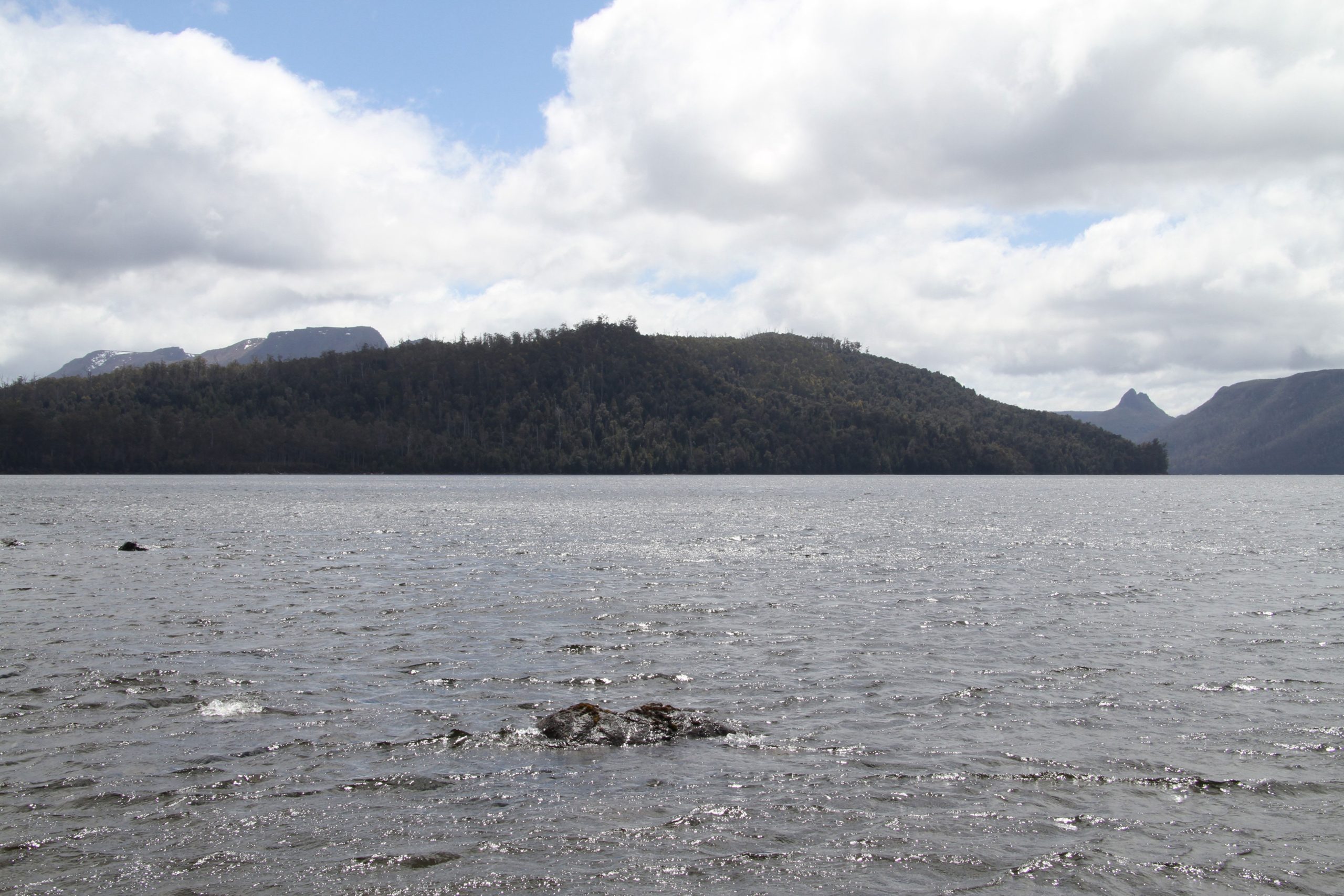
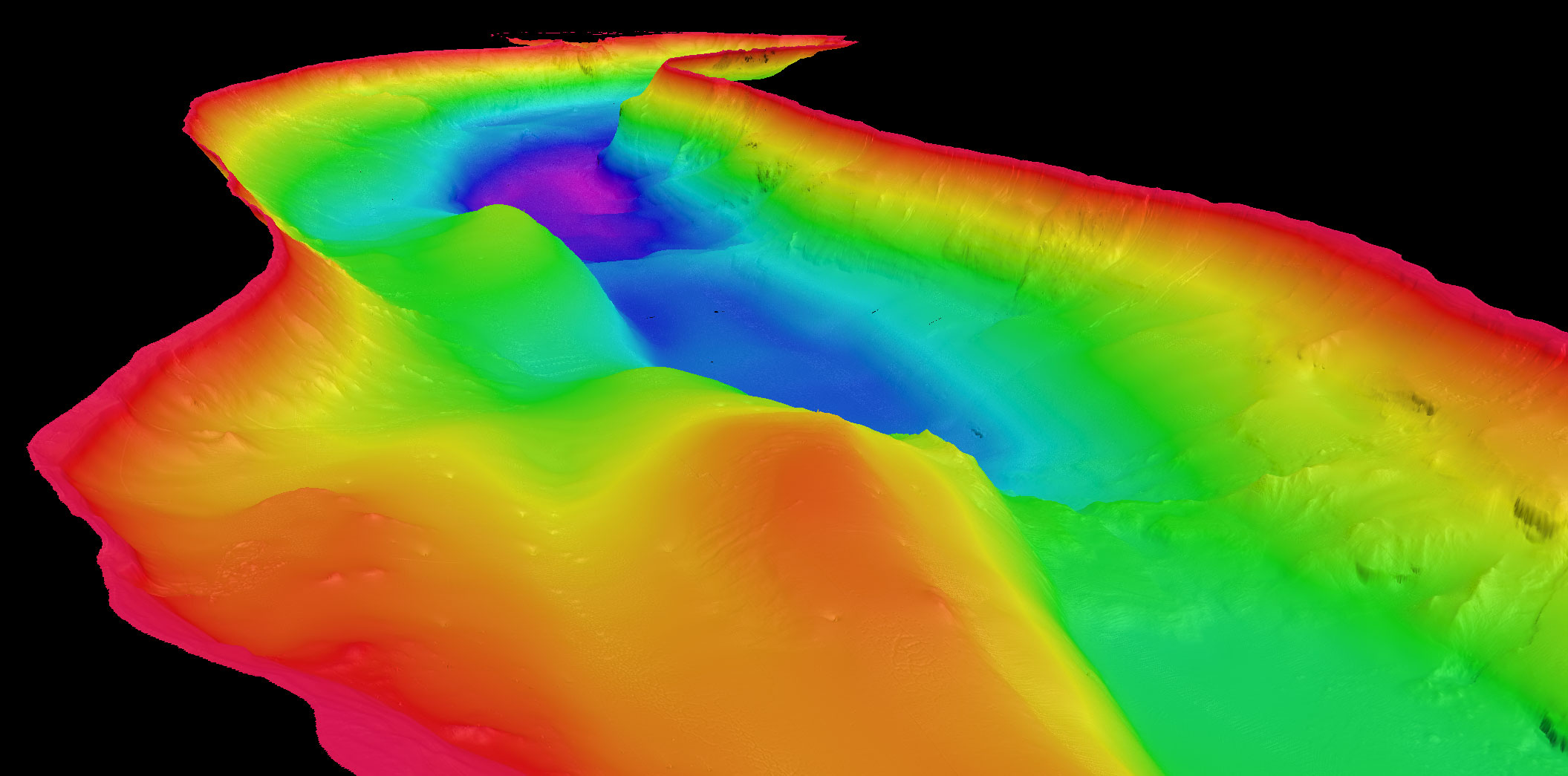
    Their work focuses on Lake St Clair, located in the island’s central highlands, which is recognized as the deepest lake in Australia.

    High Resolution Mapping of Lake St Clair, Tasmania, Viewed From South
    High resolution mapping of Lake St Clair, Tasmania, viewed from south, with colors representing water depth: red 0m to purple 163m. Credit: CSRO

    New technologies reveal hidden lake landscape

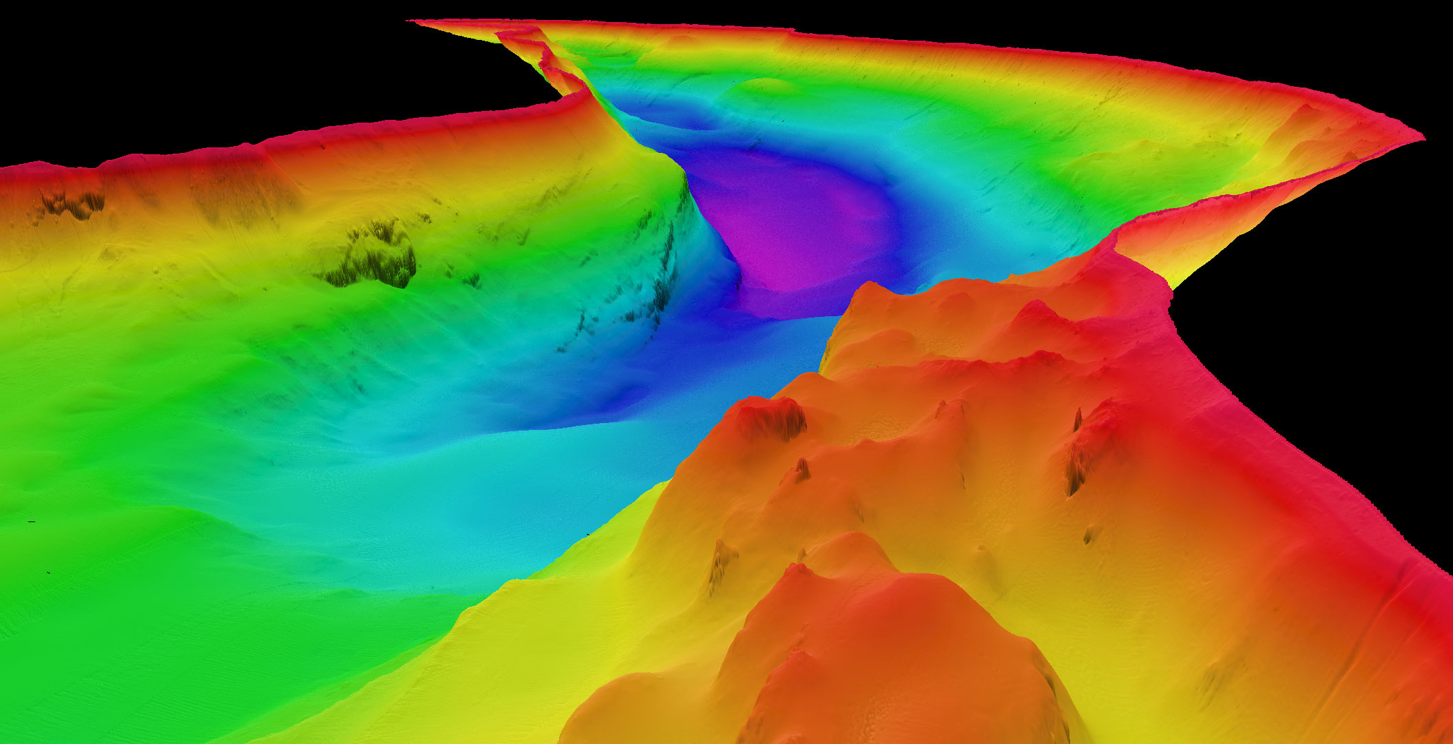
    To map the lake in unprecedented detail, scientists combined multibeam sonar with Light Detection and Ranging (LIDAR) technology. These tools allowed the team to build the first high-resolution three-dimensional model of both the lakebed and the surrounding shoreline.

    The survey revealed a complex underwater terrain that includes steep submerged cliffs, deep channels, and large rock structures hidden beneath the surface.

    Topographical Map of Central Tasmania
    Topographical map of central Tasmania overlaid with CSIRO’s new high resolution mapping of Lake St Clair, Australia’s deepest lake. Credit: Bathymetry CSIRO-Basemap from TASMAP ©State of Tasmania

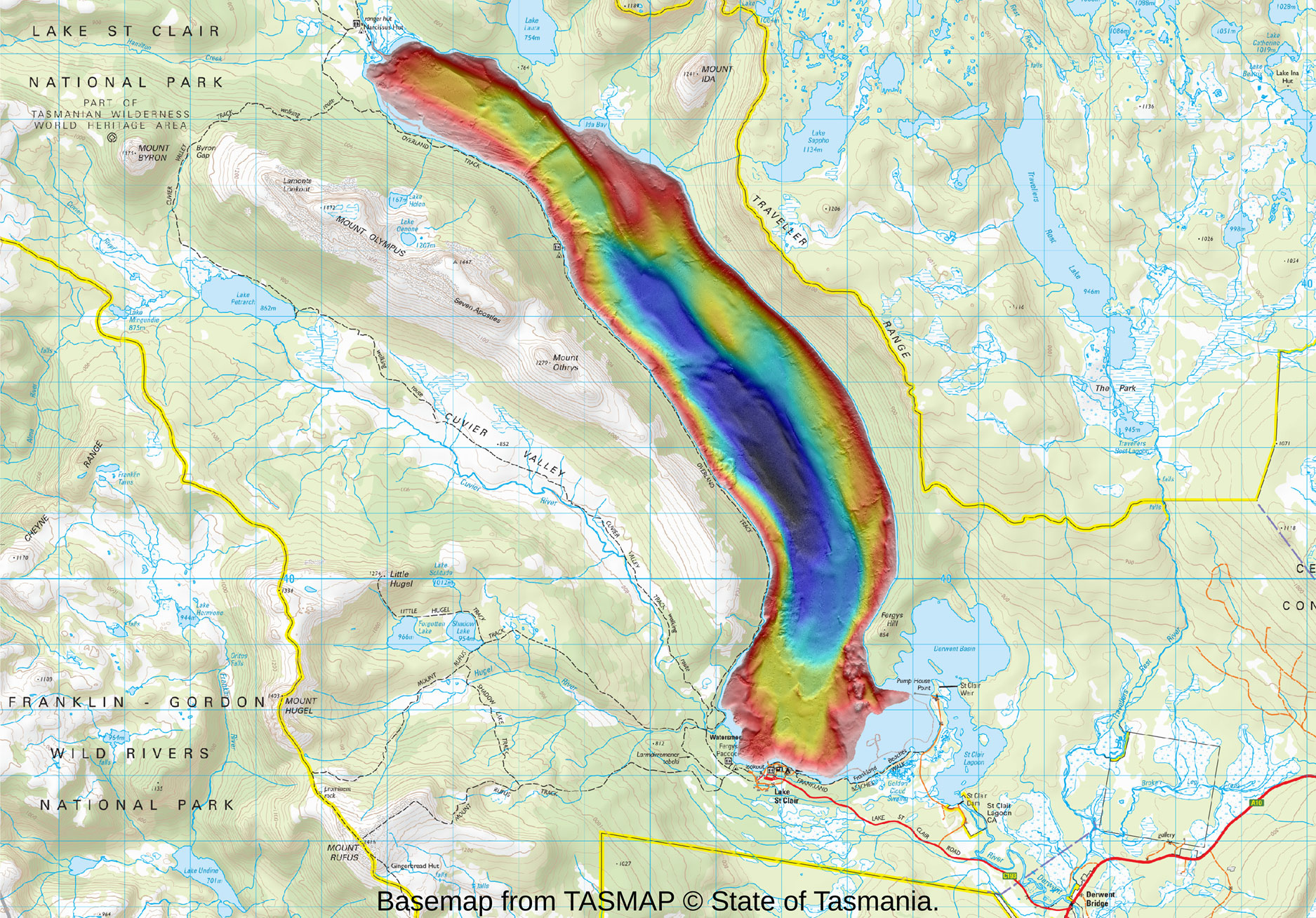
    Lake St Clair itself was shaped long ago by powerful glaciers that carved through the surrounding bedrock. Today it is widely admired for its rugged scenery and forms part of the UNESCO World Heritage-listed Cradle Mountain Lake St Clair National Park.

    Despite its popularity and scientific interest, the lake’s exact maximum depth had never been definitively measured, although earlier estimates placed it somewhere between 160 and 215 meters.

    Mapping confirms Australia’s deepest lake

    The new CSIRO survey has now resolved that uncertainty. Measurements show the deepest point of Lake St Clair reaches 163 meters. This confirms it as the deepest lake in Australia and places it well beyond the depth of any other lake in the country. For comparison, Bass Strait reaches a maximum depth of about 85 meters.

    Otter Uncrewed Survey Vessel at Lake St Clair
    The Otter, an uncrewed surface vessel, conducting shallow-water surveys at Lake St Clair to support environmental monitoring and research. Credit: CSIRO-Andrew Filisetti

    CSIRO hydrographic surveyor Augustin Déplante said the mapping provides both a clearer picture of the lake’s underwater structure and a definitive answer to the long-standing question about its depth.

    “Our mapping confirms that Lake St Clair is absolutely Australia’s deepest lake, with the next deepest lake being less than 100 meters deep,” Mr Déplante said.

    “We found Lake St Clair’s deepest point is close to the western shore on the bend in the lake about 4 kilometers north of the visitor centre, but there are several areas where the lake depth reaches 150 meters,” he said.

    Lake St Clair, Australia
    Lake St Clair, Australia’s deepest lake, surrounded by rugged forest and mountain ranges. Its pristine waters are a vital part of Tasmania’s natural heritage and a key site for ecological research. Credit: CSIRO-Matt Marrison

    Advanced mapping technology uncovers new details

    CSIRO plans to make the full three-dimensional dataset available to researchers, environmental managers, and other stakeholders. The information will support studies of underwater habitats and help scientists better understand how the lake formed.

    It may also improve safety for vessels operating on the water and support future experiments, including testing autonomous underwater vehicles.

    The mapping effort required careful surveying across the entire lake. Over the course of eight days, researchers worked through challenging weather conditions while using high-resolution multibeam echosounders. These sonar systems determine water depth by sending pulses of sound toward the lakebed and measuring the time it takes for the echoes to return.

    High Resolution Mapping of Lake St Clair, Tasmania, Viewed From North
    High resolution mapping of Lake St Clair, Tasmania, viewed from south showing deepest point of lake (in purple). Credit: CSIRO

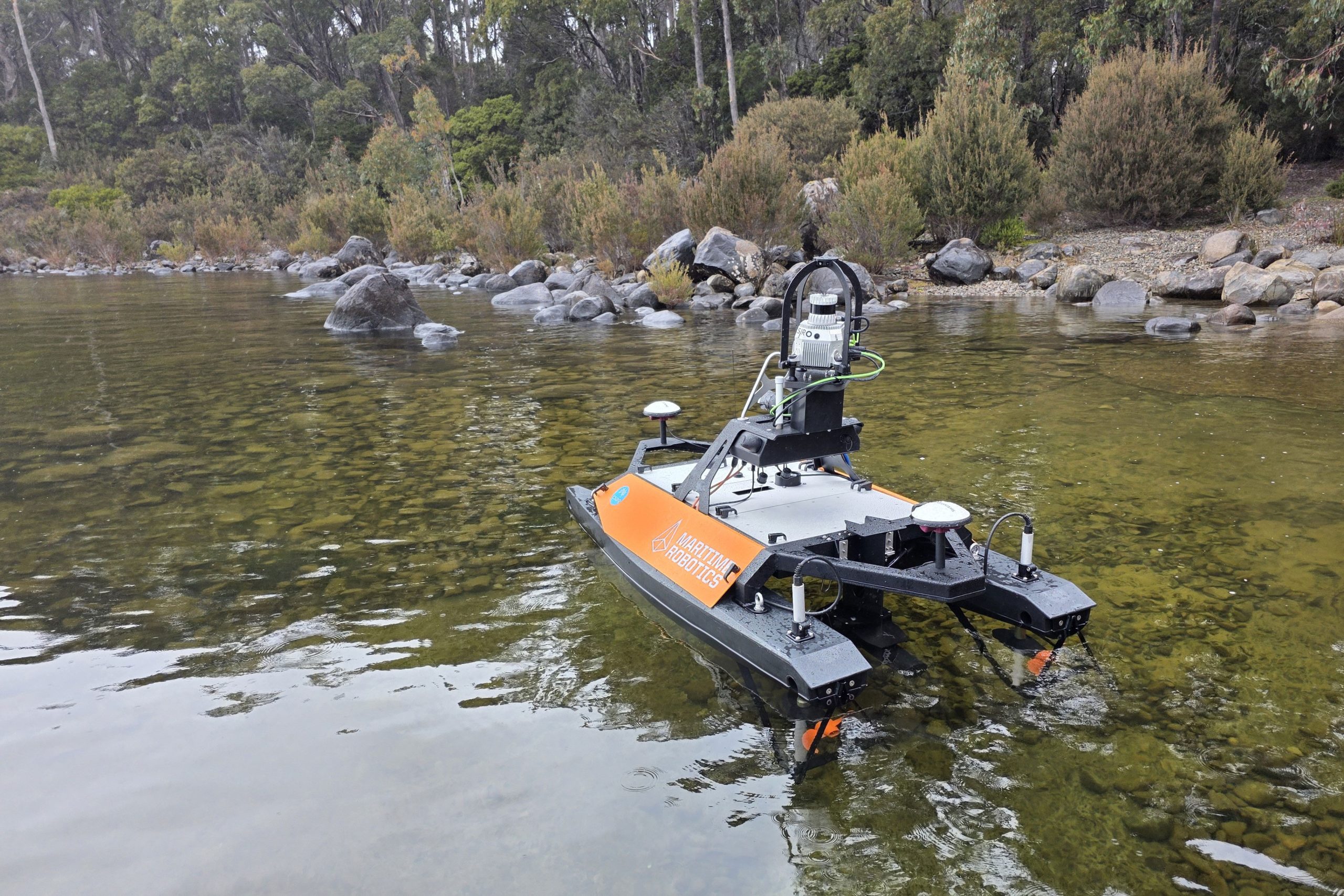
    The project relied on an eight-meter twin-hulled research vessel known as RV South Cape. In addition, the team deployed a two-meter unmanned remotely operated vessel called the Otter. Because of its smaller size, the Otter could safely survey shallow sections of the lake that were inaccessible to larger boats.

    The Otter was also equipped with LIDAR sensors to scan the lake’s shoreline. These measurements were combined with the underwater sonar data to create a single integrated three-dimensional model.

    Detailed data reveals features on the lakebed

    The resulting dataset captures the lake’s structure with remarkable precision, revealing previously unseen features along the bottom and edges of the lake.

    “The mapping is highly detailed and can identify objects as small as 50 centimeters in some places. Along the shoreline, it shows the trees that have fallen into the lake and, in deeper areas, has revealed several mysterious features on the lakebed, sparking curiosity about their origins,” Mr Déplante said.

    “While the data does not confirm the presence of a Lake St Clair ‘Loch Ness’ monster, it does offer a powerful new tool for exploring the lake’s hidden depths.

    “Importantly, the project provided us with the opportunity for cross-disciplinary training for our team and to integrate the latest technologies into our toolbox to enhance the capabilities we offer the research community.”

    Never miss a breakthrough: Join the SciTechDaily newsletter.
    Follow us on Google and Google News.

    Australia CSIRO Freshwater Geography Lakes Popular
    Share. Facebook Twitter Pinterest LinkedIn Email Reddit

    Related Articles

    New Zealand’s Southern Alps Glacier Melt Has Doubled – Up to 77% of Little Ice Age Glacier Volume Already Lost

    NASA Scientists Map Beirut Blast Damage – Devastating Explosion Rocked Port Area

    NASA Advanced Rapid Imaging Satellite Maps Blast Damage: Beirut Explosion Aftermath

    Discovered in Deep Ocean: New Current That Transports Water to One of World’s Largest “Waterfalls”

    Tracking California’s Sinking Coast From Space: San Francisco, Monterey Bay, Los Angeles, and San Diego Majorly Affected

    Deep-Earth Structures Discovered That May Signal Enormous Hidden Metal Lodes

    Earth From Space: An Incredible View of Abu Dhabi

    Vast Mineral Deposits in the Atacama Desert Seen From Space

    Rapidly Retreating Glacial Ice Leaves Species Threatened

    Leave A Reply Cancel Reply

    • Facebook
    • Twitter
    • Pinterest
    • YouTube

    Don't Miss a Discovery

    Subscribe for the Latest in Science & Tech!

    Trending News

    The Universe Is Expanding Too Fast and Scientists Can’t Explain Why

    “Like Liquid Metal”: Scientists Create Strange Shape-Shifting Material

    Early Warning Signals of Esophageal Cancer May Be Hiding in Plain Sight

    Common Blood Pressure Drug Shows Surprising Power Against Deadly Antibiotic-Resistant Superbug

    Scientists Uncover Dangerous Connection Between Serotonin and Heart Valve Disease

    Scientists Discover a “Protector” Protein That Could Help Reverse Hair Loss

    Bone-Strengthening Discovery Could Reverse Osteoporosis

    Scientists Uncover Hidden Trigger Behind Stem Cell Aging

    Follow SciTechDaily
    • Facebook
    • Twitter
    • YouTube
    • Pinterest
    • Newsletter
    • RSS
    SciTech News
    • Biology News
    • Chemistry News
    • Earth News
    • Health News
    • Physics News
    • Science News
    • Space News
    • Technology News
    Recent Posts
    • Scientists Crack Alfalfa’s Chromosome Mystery After Decades of Debate
    • Ancient Ant-Plant Alliance Collapses As Predatory Wasps Move In
    • Scientists Discover Tiny New Spider That Hunts Prey 6x Its Size
    • Natural Component From Licorice Shows Promise for Treating Inflammatory Bowel Disease
    • New Research Finds Shocking Link Between Chili Peppers and Cancer
    Copyright © 1998 - 2026 SciTechDaily. All Rights Reserved.
    • Science News
    • About
    • Contact
    • Editorial Board
    • Privacy Policy
    • Terms of Use

    Type above and press Enter to search. Press Esc to cancel.