Glaciers in the Southern Alps of New Zealand have lost more ice mass since pre-industrial times than remains today, according to a new study.
Research led by the University of Leeds, in collaboration with the National Institute of Water and Atmospheric Research (NIWA) in New Zealand, mapped Southern Alps ice loss from the end of the Little Ice Age — roughly 400 years ago — to 2019.
The study found that the rate of ice loss has doubled since glaciers were at their Little Ice Age peak extent. Relative to recent decades, the Southern Alps lost up to 77% of their total Little Ice Age glacier volume.
Climate change has had a significant impact on ice loss around the world. Not only do local communities depend on glaciers as sources of fresh water, hydropower and irrigation, but mountain glacier and ice cap melt presently accounts for 25% of global sea-level rise.
Rapid changes observed today for mountain glaciers need to be put into a longer-term context to understand global sea-level contributions, regional climate-glacier systems and local landscape evolution.
The study, published in the journal Scientific Reports, determined volume changes for 400 mountain glaciers across New Zealand’s Southern Alps for three time periods; the pre-industrial Little Ice Age to 1978, 1978 to 2009 and 2009 to 2019.
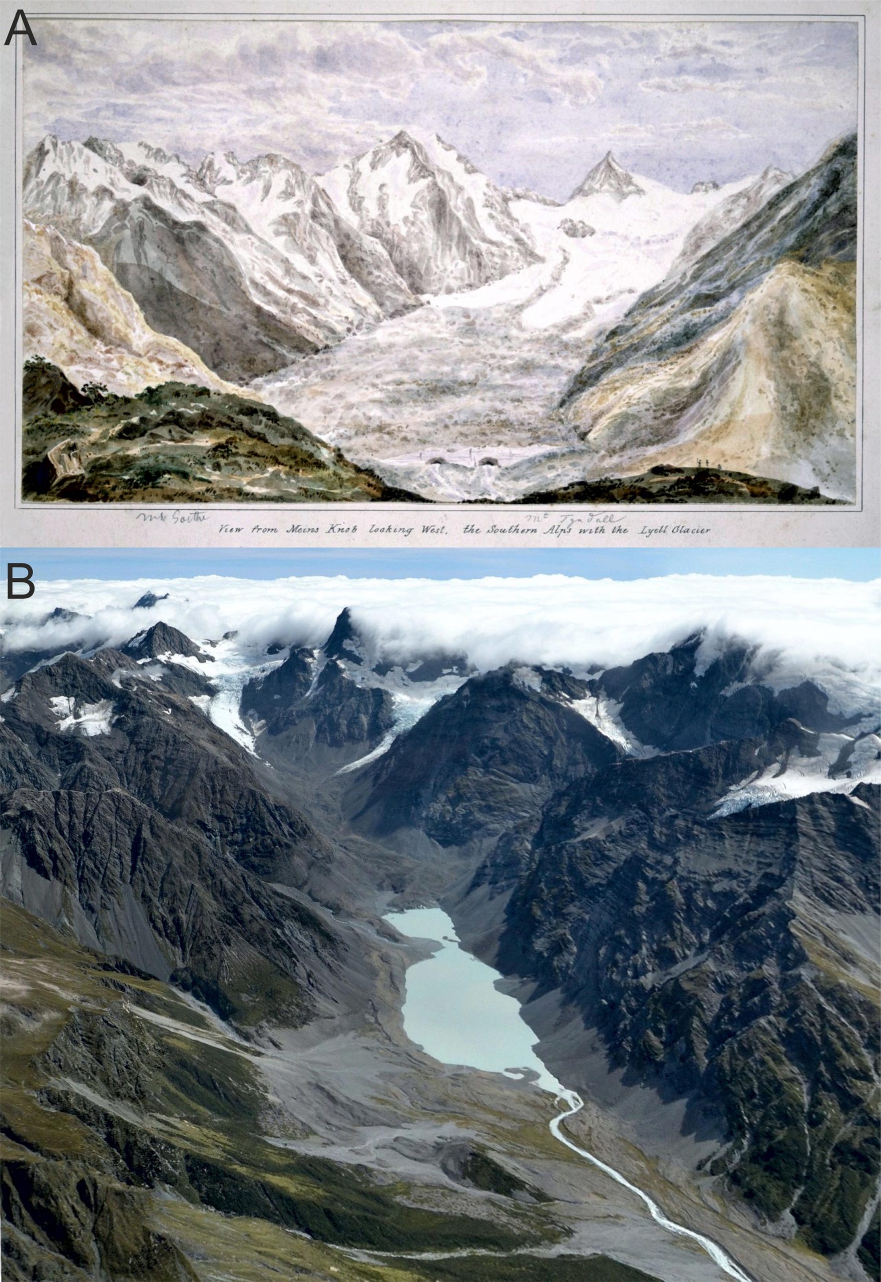
The team reconstructed glacier volumes using historical records of glacier outlines, as well as examinations of moraines and trimlines, which are accumulations of glacial debris and clear lines on the side of a valley formed by a glacier, respectively. Moraines and trimlines can indicate former ice margin extent and ice thickness changes through time.
By comparing changes in the glacier surface reconstructed during the Little Ice Age peak and the glacier surface in more recent digital elevation models, the study found that ice loss has increased two-fold since the Little Ice Age with a rapid increase in ice volume loss in the last 40 years.
Up to 17% of the volume that was present at the Little Ice Age was lost between 1978 and 2019 alone. In 2019, only 12% of ice mass remained in what was formerly the low-altitude part of the Little Ice Age glacier region — also called the ablation zone — and much of the what used to be ice-covered in the Little Ice Age ablation zone is now completely ice free.
Study lead author Dr. Jonathan Carrivick, from the School of Geography, said: “These findings quantify a trend in New Zealand’s ice loss. The acceleration in the rate of ice mass loss may only get worse as not only climate but also other local effects become more pronounced, such as more debris accumulating on glaciers surfaces and lakes at the bottom of glaciers swell, exacerbating melt.
“Our results suggest that the Southern Alps has probably already passed the time of ‘peak water’ or the tipping point of glacier melt supply. Looking forwards, planning must be made for mitigating the decreased runoff to glacier-fed rivers because that affects local water availability, landscape stability, and aquatic ecosystems.”
Co-author Dr. Andrew Lorrey is a Principal Scientist based at NIWA who was involved with the study. He says “The long-term ice volume decline, rising snowlines, and rapid disintegration of glaciers across the Southern Alps we have observed is alarming. Photographic evidence that has been regularly collected since the late 1970s show the situation has dramatically worsened since 2010.
“Our findings provide a conservative baseline for rates of Southern Alps ice volume change since pre-industrial times. They agree with palaeoclimate reconstructions, early historic evidence, and instrumental records that show our ice is shrinking from a warming climate.”
Reference: “Ice thickness and volume changes across the Southern Alps, New Zealand, from the little ice age to present” by Jonathan L. Carrivick, William H. M. James, Michael Grimes, Jenna L. Sutherland and Andrew M. Lorrey, 7 August 2020, Scientific Reports.
DOI: 10.1038/s41598-020-70276-8
Never miss a breakthrough: Join the SciTechDaily newsletter.
Follow us on Google and Google News.
2 Comments
“The study found that the rate of ice loss has doubled since glaciers were at their Little Ice Age peak extent.”
Why should we be surprised that ice loss has increased since the peak of the LIA? Or, that it is melting even faster since the end of the LIA? The very definition of the end of an ice age implies that there will be decreased ice accumulation and subsequently more ablation.
There is concern about water supplies. However, consider the alternative. If it were getting colder and less ice was melting, there would be less water available for human use. Climate is not static. It is always changing and humans must adapt.
I went through the paper published in Feb 2018 in The Journal of Geology about extraordinary biomass burning around 10,800 BCE. I found it fascinating.
Would anybody be willing to have a look at the following statement?
Any comments are appreciated. Thank you.
“Around 10,800 BCE, likely within the span of 21 years between 10,818 BCE and 10,797 BCE, ∼9% of Earth’s terrestrial biomass, on ∼10 million km2 (area as big as the US), burned.
The concentrations of soot, used to estimate the global amount of biomass burned, suggest that wildfires around 10,800 BCE consumed considerably more biomass than during the K-Pg extinction event.
It would be interesting to calculate how much CO2 must have been released when ∼9% of world terrestrial biomass on ∼10 million km2 burned.
The wildfires on 70,000 km² in Australia this year are estimated to release about 900 million tons of CO2, which equals to double the country’s total yearly fossil fuel emissions.”