
Snow drought and record warmth have pushed Lake Powell to its lowest level on record, deepening pressure on the Colorado River system.
Snow drought and exceptional warmth across the Colorado Basin in 2026 helped push water storage in major Western reservoirs to historic lows.
By summer, the effects of the weak mountain snowpack from winter 2025-2026 were clearly visible downstream at Lake Powell. With little snow left to melt and feed the Colorado River, inflows slowed dramatically. By late August and early September, Lake Powell, the second largest reservoir in the United States, had fallen to record low levels.
Satellite Images Show Lake Powell’s Dramatic Decline
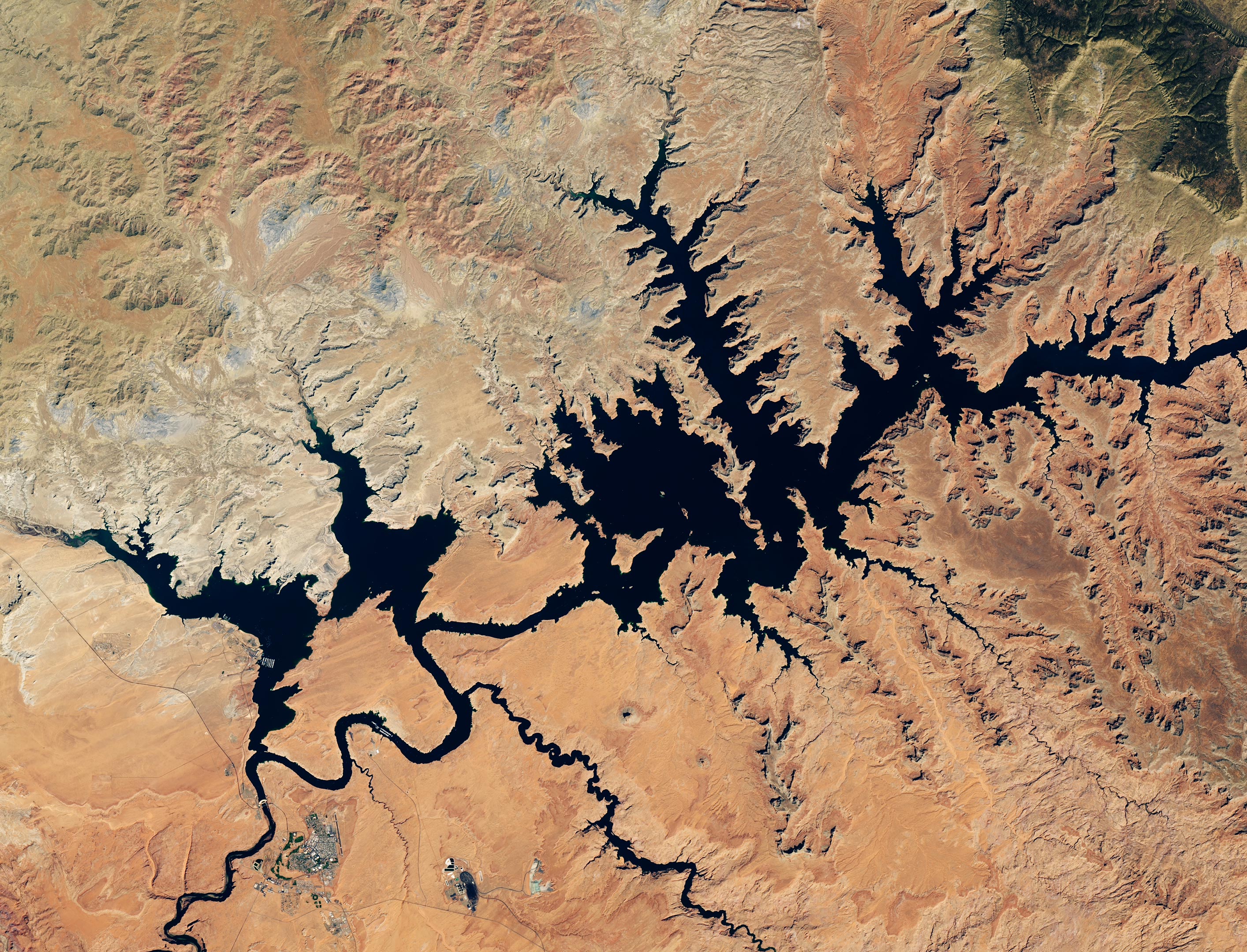
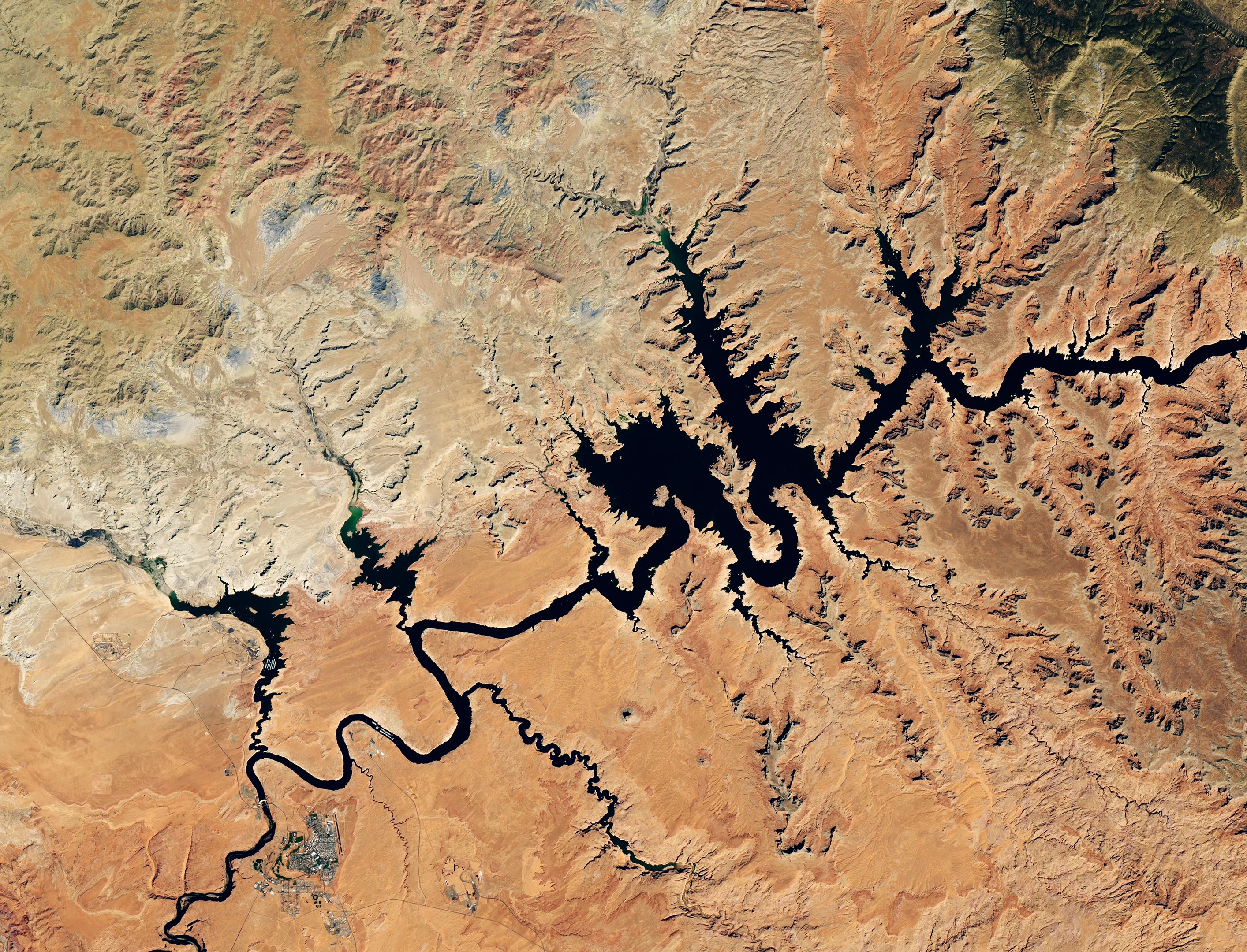
Satellite images captured a striking comparison between Lake Powell in 2017 and 2026. The images show an area just upstream from Glen Canyon Dam as seen by the OLI (Operational Land Imager) aboard the NASA USGS Landsat 8 satellite on September 1, 2017 (above), and September 10, 2026 (below).
When the 2026 image was acquired, Lake Powell’s water elevation measured 3,517.24 feet. Roughly a month earlier, the reservoir had already fallen below the previous record low of 3,519.92 feet, which was set on April 13, 2023. Water levels continued declining into early September. By contrast, the 2017 image captures Lake Powell during one of its highest water levels of the past decade.
The Colorado River flows into Lake Powell before continuing downstream toward Lake Mead. Lake Mead also reached record low levels in August 2026.
The river system, managed by the U.S. Bureau of Reclamation (USBR) and other agencies, is critical to the Southwest. It supplies water and electricity to more than 40 million people, including residents of Las Vegas, Phoenix, Los Angeles, and San Diego. It also provides irrigation water for about 5 million acres of farmland.
A Snow Drought Starved the Colorado River
Because much of the Colorado Basin is arid or semi arid, snow in the surrounding mountains serves as an important natural water reservoir. A substantial share of the Colorado River’s water begins as snow that accumulates at high elevations before melting during spring and early summer.
During winter 2025-2026, however, the Upper Colorado Basin received unusually little snow. Similar conditions affected mountainous regions across the U.S. West, creating what scientists call a snow drought.
Periods of record warmth made the situation worse by further reducing the snowpack. When spring arrived, there was far less snow available to melt and flow into rivers and reservoirs. As a result, the seasonal runoff that normally helps replenish Lake Powell provided relatively little relief.
Officials Move Water to Protect Hydropower
The U.S. Bureau of Reclamation began taking action in April 2026 to stabilize Lake Powell. Without intervention, the agency warned that the reservoir could fall below the elevation required for hydropower generation as early as August 2026.
To help maintain water levels, USBR began sending additional water from Flaming Gorge Reservoir in northern Utah and southern Wyoming into Lake Powell.
Officials also reduced the amount of water being released from Lake Powell toward Lake Mead. Other planned water releases were altered as well. The agency canceled a “controlled flood” planned for April that was intended to rebuild sandbars used as fish habitat. It also skipped a “cool mix” release in August that had been designed to help protect native species.
Decades of Drought Continue to Strain the Southwest
The latest reservoir decline comes against the backdrop of a much longer water shortage. Drought in the U.S. Southwest has persisted since around the beginning of the 21st century. Researchers have described the prolonged dry period as a megadrought.
Those conditions continue to put enormous pressure on the Colorado River system and the communities, farms, ecosystems, and power infrastructure that depend on it.
NASA-supported projects are helping water managers better understand changing conditions across the basin. Many combine satellite observations with ground measurements and computer modeling to track drought, snow, soil moisture, and water storage.
At the headwaters of the Colorado River, a dashboard built around the Western Land Data Assimilation System (WLDAS) provides current visualizations of soil moisture, snow water equivalent, and evapotranspiration. The information helps support Colorado’s drought task force and contributes to weekly U.S. Drought Monitor maps.
NASA Tools Track Drought Across the Basin
Closer to Lake Powell, the Drought Severity Evaluation Tool, developed in collaboration with the Navajo Nation, allows leaders to track local drought indicators, changes in precipitation, and vegetation health across tribal lands. (With funding from NOAA’s National Integrated Drought Information System, its adoption expanded to Oklahoma’s Chickasaw and Choctaw Nations in 2025.)
Researchers at Arizona State University, in partnership with the Central Arizona Project, created another resource: the Colorado River Integrated Assessment tool. It brings together improved modeling and information validated with NASA satellite observations in a single interactive platform.
The system includes data on snowpack, surface water, groundwater storage, soil moisture, and other conditions across the Colorado River Basin, giving decision-makers a broader view of how water supplies are changing throughout the region.
NASA Earth Observatory images by Lauren Dauphin, using Landsat data from the U.S. Geological Survey and lake elevation data from the U.S. Bureau of Reclamation.
Never miss a breakthrough: Join the SciTechDaily newsletter.
Follow us on Google and Google News.