
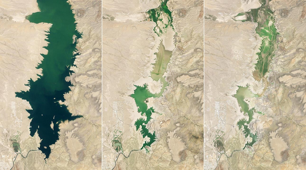
New Mexico’s largest reservoir plunged to just 1.4 percent capacity in July 2026, revealing the dramatic impact of prolonged drought and record early snowmelt.
NASA is using satellite data to help water managers understand the shrinking supply and prepare for future shortages.
When astronaut John Glenn remarked on the landscape below him while orbiting Earth in 1962, one feature caught his attention: a green, irrigated valley northwest of El Paso, Texas, surrounded by desert. Human-made lakes along the Rio Grande have helped make agriculture possible in this otherwise dry region. Irrigation water supports fields of alfalfa, cotton, onions, pecans, and Hatch green chiles, one of the area’s best-known crops.
Drought Tightens Its Grip on the Rio Grande
That agricultural lifeline has come under growing pressure as unusually dry conditions have persisted across the Rio Grande basin. Extreme drought has affected the region for several years, reducing the water available to replenish rivers and reservoirs.
Conditions became even more difficult in 2026. At the Rio Grande’s headwaters in the southern Rocky Mountains, the earliest snowmelt on record further reduced the amount of water available later in the season.
New Mexico’s Largest Reservoir Falls to 1.4 Percent
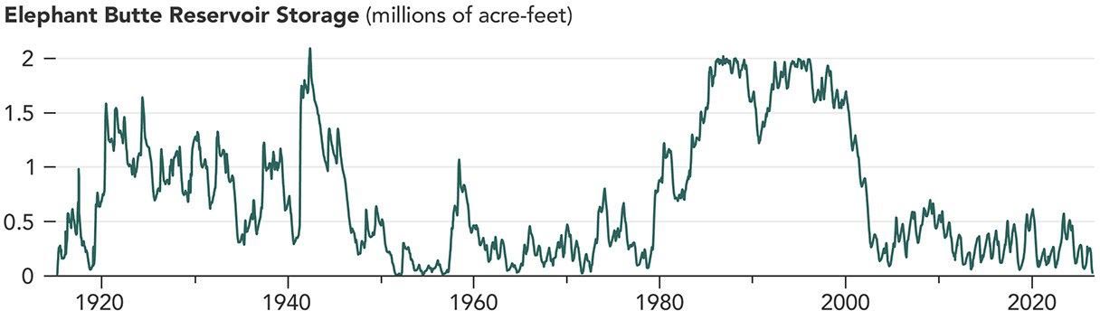
Together, these conditions helped push Elephant Butte Reservoir, the largest reservoir in New Mexico, to its lowest level since 1971. When the image above was captured on July 27, 2026 (right), the reservoir held just 1.4 percent of its capacity.
The contrast with earlier decades is striking. Elephant Butte was nearly full on June 2, 1994 (left), and water levels remained relatively high through much of the period from 1985 to 2000. During another major drought, the reservoir reached its annual low of 2.9 percent capacity on July 8, 2013 (center).
The exceptionally low water in 2026 exposed debris that had been hidden along the shoreline and left boat ramps at Elephant Butte Lake State Park coated with sediment. However, the reservoir appears to have reached its lowest point for the year in late July. Water releases for agriculture ended after July 28, according to state officials, allowing the reservoir to begin slowly gaining water again.
Managing a Shrinking Water Supply
The prolonged drought has underscored the broader challenges facing the Rio Grande and the communities that depend on it. Water users in both New Mexico and Texas draw on surface water and groundwater throughout the valley. With supplies under increasing strain, managers must carefully plan how water is stored, allocated, and shared.
Several projects supported by NASA’s Western Water Action Office (WWAO) are designed to give water managers better information for making those decisions. The projects combine satellite observations with other measurements to provide a more detailed picture of changing water conditions across the region.
NASA Satellites Help Track the Rio Grande
In one effort, researchers developed a model that uses NASA satellite observations of factors including soil moisture and evapotranspiration. Evapotranspiration measures water moving from the land into the atmosphere through evaporation and plant activity. The resulting near-real-time tool supplements the Elephant Butte Irrigation District’s existing system for allocating water.
Another project combined satellite measurements of water surface heights with observations collected by drones and instruments on the ground. Researchers used the combined data to examine how groundwater pumping changes the flow of the Rio Grande. The WWAO says this information can help water managers administer water rights.
NASA scientists are also participating in a federal study focused on the Upper Rio Grande. The effort seeks to better understand regional water needs, estimate how much water may be available in the future, and develop data-based tools that can help communities manage increasingly limited supplies.
NASA Earth Observatory images by Michala Garrison, using Landsat data from the U.S. Geological Survey and water volume data from the Texas Water Development Board.
Never miss a breakthrough: Join the SciTechDaily newsletter.
Follow us on Google and Google News.
1 Comment
This has as much to do with water useage policy as changing weather patterns. Adapt or else!