
A powerful climate signal is building across the tropical Pacific, and satellites can see it rising in the ocean itself.
El Niño returned in June 2026, marked by warmer-than-average waters in the central and eastern equatorial Pacific. NOAA declared the event on June 11 after sea surface temperatures stayed at least 0.5 degrees Celsius (0.9 degrees Fahrenheit) above normal for several months. By then, NASA and its partners were already tracking another warning sign from space: higher sea surface height.
That rising ocean surface matters because warm water expands. When a large mass of warm water spreads across the Pacific, satellites such as Sentinel-6 Michael Freilich can detect the subtle lift in sea level. In this case, the height changes are not just a surface detail. They reveal where the ocean is storing heat below the surface, which can help show whether El Niño has enough energy to reshape weather patterns months later.
El Niño can shift rainfall, heat, and storm tracks around the world. It often raises the odds of wetter conditions across the U.S. Southwest while increasing drought risk in parts of the western Pacific, including Indonesia and Australia. Its strongest effects often arrive during Northern Hemisphere winter, when changes in the tropical Pacific can ripple through the atmosphere and alter weather far from the ocean where they began.
How Space Tracks Hidden Ocean Heat
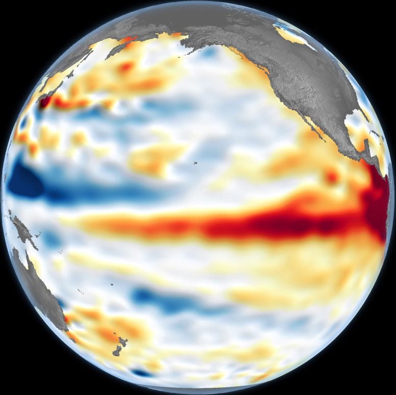
The June 8, 2026, satellite map showed higher-than-average sea levels across parts of the central and eastern Pacific. Red areas marked elevated sea surface height, white showed near-normal levels, and blue indicated lower-than-average water levels. Scientists removed seasonal patterns and long-term sea level trends from the data so shorter-term signals, including El Niño, stood out more clearly.
The observations came from the Sentinel-6 Michael Freilich satellite, launched in 2020 by NASA and led by ESA (European Space Agency). Scientists at NASA’s Jet Propulsion Laboratory (JPL) processed the data.
The buildup did not appear suddenly. Earlier in spring 2026, Sentinel-6 detected large pulses of warm water, called Kelvin waves, moving eastward across the equatorial Pacific. These waves can be an early sign that El Niño is forming. They often develop when trade winds weaken or briefly reverse, allowing warm water that had been pushed toward the western Pacific to slide back toward the Americas.
Kelvin Waves Fuel a Growing El Niño
As that warm water moves east, it deepens the warm upper layer of the ocean, pushes the thermocline farther down, and reduces the normal upwelling of cooler water along the Pacific coasts of the Americas. In simple terms, the ocean begins to cap itself with a deeper blanket of heat.
That is why sea surface height is so useful. A thin layer of warm surface water may fade quickly. A deeper reservoir of heat is harder to disrupt and can feed a stronger, longer-lasting El Niño.
Could 2026 Rival the Historic 1997 Event?
JPL sea level researcher Séverine Fournier, deputy project scientist for Sentinel-6 Michael Freilich, said conditions in the western Pacific on June 8 resembled those seen at the same point in 1997, when one of the most powerful El Niño events on record was taking shape. The 2026 event was not an exact repeat, however. Warm conditions in the eastern Pacific were still lagging behind 1997 because fewer Kelvin waves had arrived by that date.
Even so, more warm Kelvin waves appeared to be heading east, suggesting the event was still gaining strength. Whether 2026 approaches the scale of 1997 will depend on how the ocean and atmosphere interact in the weeks ahead. “For now, it looks like it’s going to be a big one—more so than I would have said last week—but we still need more observations to know what’s going to happen.”
Never miss a breakthrough: Join the SciTechDaily newsletter.
Follow us on Google and Google News.
5 Comments
.5c it should be 32.9f
What about implications of the el. Nino for southern Africa I. E Zimbabwe. You never write about that
Drain the resoviroirs of all the water behind the dams in the Colorado River basins. Allow all water to flow into the gulf and cool the seawater there. It will flow into the pacific and cool the El nino. Restore the natural balance and bring equilibrium to the seas.
Even if there were any water left to drain, your simple solution overlooks how one gets the water from the Gulf to the Pacific. If the water isn’t used for irrigation, what do you propose to do with all the bodies of the people who starve to death when the USA can’t export grain? I don’t think that you have thought this through!
The discontinuous red trace across the Pacific, with the highest temperatures localized near the volcanic Galapagos Islands, suggests to me that geothermal heat from submarine vents rises to the ocean surface and backs up against the shores of Ecuador with westerly winds.
Why should the ocean be “storing heat below the surface” if the source of heat (the sun) heats the surface more than waters immediately above the thermocline?
What is the source of the concurrent, similarly discontinuous heat plume, off the south-east coast of Japan?
In their zeal to blame fossil fuels for warming, I think that they are too quick to dismiss alternative hypotheses.