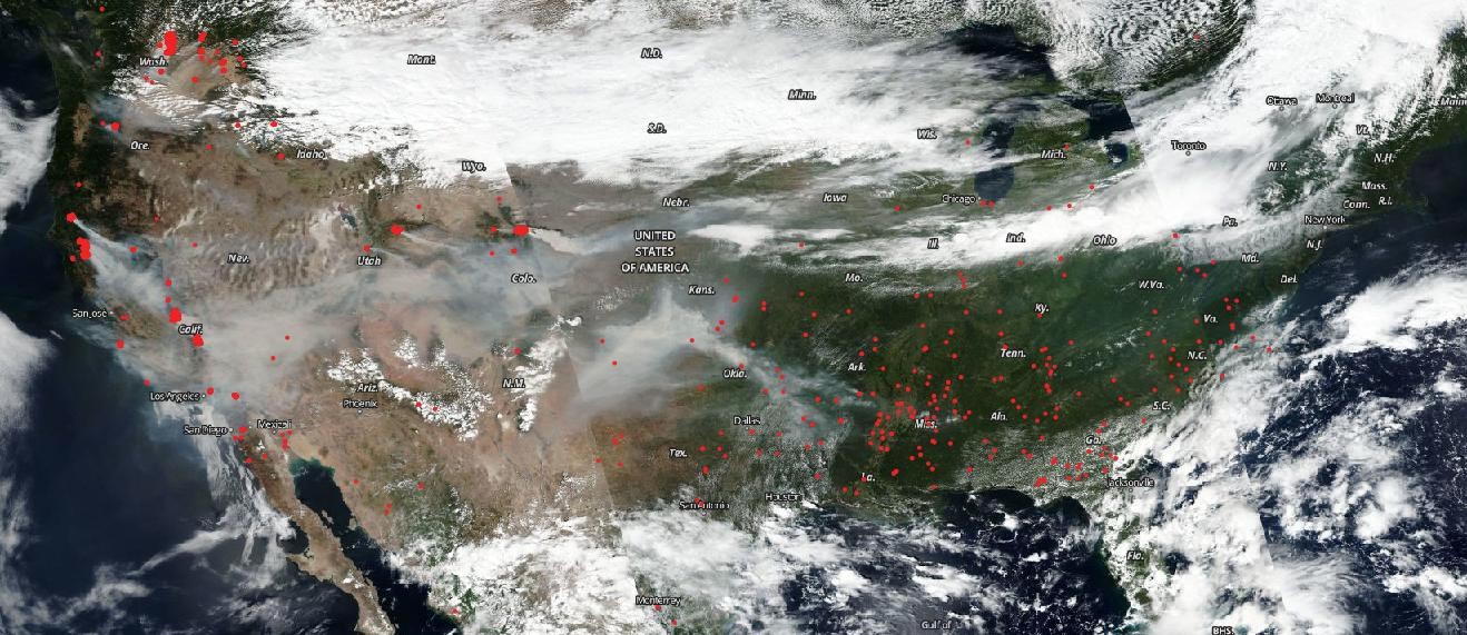
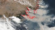
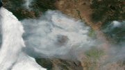
The NOAA/NASA Suomi NPP satellite captured an image of fires across America on September 7, 2020. Credit: NOAA/NASA
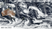
On September 7, 2020, NOAA/NASA’s Suomi NPP satellite provided two different views of how fires are affecting the U.S. A true-color image of the United States appears on the top image. Obscuring the surface is a blanket of smoke from California to Arkansas with a haze present over the East Coast as well. The Suomi NPP satellite also provided information about aerosols that were released from these fires and have traveled across the United States’ landscape as shown in the image below.
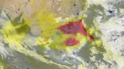
Although the OMPS suite was designed to measure ozone it also has the capability of measuring other atmospheric particles like sulfur dioxide and ash. The aerosol index (AI) value is related to both the thickness and height of the atmospheric aerosol layer. For most atmospheric events involving aerosols, the AI ranges from 0.0 to 5.0, with 5.0 indicating heavy concentrations of aerosols that could reduce visibilities or impact health. Color codes range from colorless (0.0) through yellow (.5 – 2.6), orange (2.7-3) deep red (>3 – 5.0). This image shows a significant area of deep red range which means aerosols in the area could potentially be dangerous to the health of those in that area.

The OMPS (Ozone Mapper and Profiler Suite) on the Suomi NPP satellite was used to provide this image of the aerosols released from the burning fires which have traveled east. Credit: NOAA/NASA
The smoke released by any type of fire (forest, brush, crop, structure, tires, waste or wood burning) is a mixture of particles and chemicals produced by incomplete burning of carbon-containing materials. All smoke contains carbon monoxide, carbon dioxide, and particulate matter (PM or soot). Smoke can contain many different chemicals, including aldehydes, acid gases, sulfur dioxide, nitrogen oxides, polycyclic aromatic hydrocarbons (PAHs), benzene, toluene, styrene, metals and dioxins. The type and amount of particles and chemicals in smoke varies depending on what is burning, how much oxygen is available, and the burn temperature.
High aerosol concentrations not only can affect climate and reduce visibility, they also can impact breathing, reproduction, the cardiovascular system, and the central nervous system, according to the U.S. Environmental Protection Agency. Since aerosols are able to remain suspended in the atmosphere and be carried in prevailing high-altitude wind streams, they can travel great distances away from their source as evidenced in these images and their effects can linger.
NASA’s Earth Observing System Data and Information System (EOSDIS) Worldview application provides the capability to interactively browse over 700 global, full-resolution satellite imagery layers and then download the underlying data. Many of the available imagery layers are updated within three hours of observation, essentially showing the entire Earth as it looks “right now.” Actively burning fires, detected by thermal bands, are shown as red points.
Images Courtesy: NASA Worldview, Earth Observing System Data and Information System (EOSDIS).
Be the first to comment on "NOAA-NASA Satellite Captures Fires, Smoke, Sulfur Dioxide, and Ash Across America"