
Close Menu
    Facebook X (Twitter) Instagram
    SciTechDaily
    • Biology
    • Chemistry
    • Earth
    • Health
    • Physics
    • Science
    • Space
    • Technology
    Facebook X (Twitter) Pinterest YouTube RSS
    SciTechDaily
    Home»Technology»Sandy Island, The Island That Wasn’t There
    Technology

    Sandy Island, The Island That Wasn’t There

    By SciTechDailyJanuary 7, 2013No Comments2 Mins Read
    Facebook Twitter Pinterest Telegram LinkedIn WhatsApp Email Reddit
    Share
    Facebook Twitter LinkedIn Pinterest Telegram Email Reddit
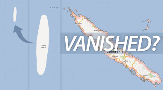
    sandy-island-missing
    The supposed Sandy Island in the Coral Sea, depicted on Google Earth and Google Maps between Australia and New Caledonia, couldn’t be found by Australian scientists during a recent geological expedition.

    A New Zealand researcher thinks that he has solved the riddle of a mysterious South Pacific island shown on Google Earth and world maps, but which doesn’t really exist. He thinks that a whaling ship from 1876 is to blame.

    The phantom landmass in the Coral Sea is shown as Sandy Island on Google Earth and Google Maps, and it is supposed to be midway between Australia and New Caledonia. The Times Atlas of the World identifies it as Sable Island, but Australian scientists who recently went searching for it during a geological expedition couldn’t find it.
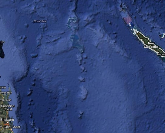
    A South Pacific island identified on Google Earth, now blacked out, never existed. Credit: Google Maps
    A South Pacific island identified on Google Earth, now blacked out, never existed. Credit: Google Maps

    Shaun Higgins, a researcher at the Auckland Museum, started investigating this. He claims that it never existed and that a whaling ship was the source of the original error. The whaling ship Velocity recorded the island, reporting a series of heavy breakers and some sandy islets.

    “My supposition is that they simply recorded a hazard at the time. They might have recorded a low-lying reef or thought they saw a reef. They could have been in the wrong place. There is all number of possibilities,” states Higgins.

    “But what we do have is a dotted shape on the map that’s been recorded at that time and it appears it’s simply been copied over time.”

    Sandy Island was also on Yahoo Maps as well as Bing Maps and Google told AFP last month it always welcomed feedback on maps and “continuously explore(s) ways to integrate new information from our users and authoritative partners into Google Maps.”

    It appears that Sandy Island has now been taken off Google Earth.

    Never miss a breakthrough: Join the SciTechDaily newsletter.
    Follow us on Google and Google News.

    GPS Imaging Map Satellites
    Share. Facebook Twitter Pinterest LinkedIn Email Reddit

    Related Articles

    Your GPS Lies in Cities. Scientists Finally Fixed It

    Nanoantennas Illuminate New Science: The Revolution in Radiative Decay Imaging

    Echoes of Innovation: Caltech’s 3D Leap in Laser Photoacoustic Imaging

    NanoVision Unleashed: PicoRulers Revolutionizing Cellular Imaging

    Soaring Beyond GPS: How Quantum Photonic Chips Can Revolutionize Drone Navigation

    Solving a “Holy Grail” Optical Imaging Problem – Scientists Develop Neural Wavefront Shaping Camera

    This Curious Device Could Usher In GPS-Free Navigation

    Apple Maps – 3 Times More Likely To Get You Lost Than Google

    Commercial Network of Microsatellites Aims to Help Weather Prediction

    Leave A Reply Cancel Reply

    • Facebook
    • Twitter
    • Pinterest
    • YouTube

    Don't Miss a Discovery

    Subscribe for the Latest in Science & Tech!

    Trending News

    Sitting Up Straight Could Actually Help You Make Better Decisions

    Never-Before-Seen Vortices Are Swirling Across the Sun

    This Common Amino Acid May Help the Body Fight Cancer and Viruses

    Low-Protein “Longevity Diet” Linked to Fat Loss, Muscle Preservation, and Healthy Aging

    How Prehistoric Poop Changed Earth’s Ecosystems Forever

    This Fossil Upends a Decades-Old Debate About Snake Evolution

    A Blood Test Years Before Cancer May Reveal a Hidden Warning Sign

    Starlink Satellites Reveal a Hidden Atmosphere 300 Miles Above Earth

    Follow SciTechDaily
    • Facebook
    • Twitter
    • YouTube
    • Pinterest
    • Newsletter
    • RSS
    SciTech News
    • Biology News
    • Chemistry News
    • Earth News
    • Health News
    • Physics News
    • Science News
    • Space News
    • Technology News
    Recent Posts
    • Astronomers Caught a Star Exploding Almost the Instant It Began
    • Empty Space May Not Be Empty After All: Magnetar Reveals a Bizarre Quantum Effect
    • Humanity May Soon Have the Technology To Reach Other Star Systems
    • A “Double Punch” Nanoparticle Could Reveal and Destroy Brain Cancer Cells
    • Popular GLP-1 Weight-Loss Drugs Linked to 30% Lower Breast Cancer Risk
    Copyright © 1998 - 2026 SciTechDaily. All Rights Reserved.
    • Science News
    • About
    • Contact
    • Editorial Board
    • Privacy Policy
    • Terms of Use

    Type above and press Enter to search. Press Esc to cancel.