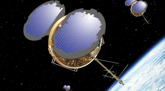
The COSMIC radio-sounding satellites are aging but may set the stage for a commercial system. Credit: OSC/UCAR
Most orbiting satellites point down towards Earth, but the satellites of the Constellation Observing System for Meteorology look sideways. Ionosphere and Climate (COSMIC) look towards the curving horizon in order to track the dozens of satellites that are part of the Global Positioning System. By tracking their radio signals, COSMIC is providing atmospheric data that enhances weather forecasts and climate models.
The fleet, which was launched six years ago and cost $100 million, is nearing the end of its operational life, with one satellite of the original six already scrapped. At a workshop last month at the University Corporation for Atmospheric Research (UCAR) in Boulder, Colorado, researchers proposed a network of 24 microsatellites, dubbed Community Initiative for Cellular Earth Remote Observation (CICERO) to replace it. These microsatellites could help address a gap in atmospheric data.
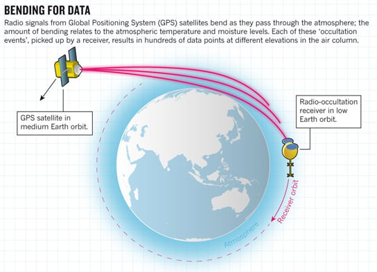
Infographic via Nature
COSMIC uses the length of the delay in GPS radio signals to measure the atmospheric density, which provides information on temperature and moisture levels. Many of these measurements are taken each day.
Radio-occultation has been used in planetary science since 1965. It was used by NASA’s Mariner 5 spacecraft to measure the pressure of Mars, and by the Voyager probes to sample the atmospheres of Jupiter, Saturn, Uranus and Neptune.
The mission has demonstrated its benefits since satellites relying on IR sounders cannot see through clouds. Microwave sounders can be confounded by moisture, but the radio waves seen by COSMIC pass through the worst storms. The radio occultation measurements depend only on the arrival of a signal, which can be timed using atomic clocks and compared between satellite systems.
A possible successor mission, COSMIC-2, could be launched in 2016 and use six satellites to orbit a narrow section of the tropics, gathering data and reducing the uncertainty in measurements of hurricane intensities by 25%.
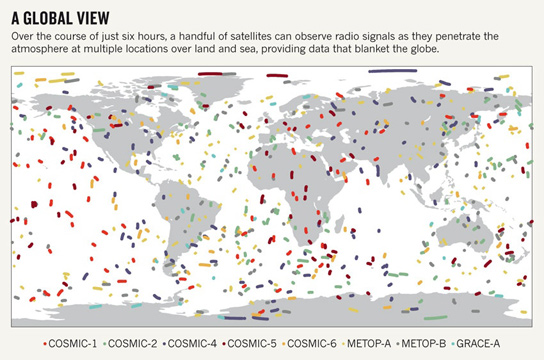
Infographic via Nature. Source: ECMWF
CICERO has it is advantages and would observe many more occultations than COSMIC because each would track not only the 32 GPS satellites, but also the 24 spacecraft in the Russian Global Navigation Satellite System and the 30 satellites that will comprise Europe’s Galileo system by the end of the decade. CICERO could generate 30,000 soundings per day, or even more.
This could help overcome a drawback of radio-occultation data since conventional weather satellites offer precise horizontal resolution relative to a specific spot on the Earth, whereas radio soundings provide high-resolution measurements vertically through the air column, with coarse horizontal resolution. CICERO will make up for that by surrounding Earth with sensors that will allow for observations along crossing sightlines, sharpening the horizontal resolution of the measurements.
The plan is for CICERO to be built and launched with private funds, and then license the data to agencies in the United States and, potentially, elsewhere. It’s hoped that CICERO will be launched before NOAA’s JPSS, a $12.9-billion program of five weather satellites with microwave and IR sensors.






Be the first to comment on "Commercial Network of Microsatellites Aims to Help Weather Prediction"