
Researchers created the first detailed electrical map beneath the United States, improving the ability to monitor solar storm risks and understand hidden geological structures.
A solar storm on the scale of the event that triggered a nine-hour blackout in Québec in 1989 could cause far greater disruption if it struck the eastern United States today. Scientists have now developed improved methods to detect these storms before they hit by mapping hidden electrical structures beneath the ground, revealing how underground geology can influence damage to power grids.
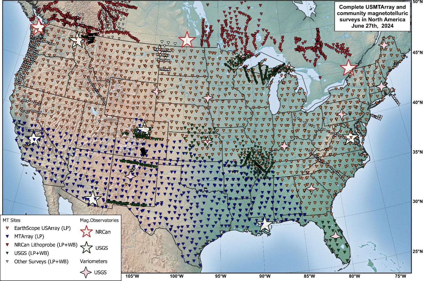
After 18 years of research and measurements taken at more than 1,800 locations nationwide, the United States Magnetotelluric Array (USMTArray) has completed the first large-scale survey of the continent’s underground electrical properties. In a new study, researchers from the Center for Astrophysics | Harvard & Smithsonian (CfA) unveiled a three-dimensional map showing how electrical currents move through buried rocks, fluids, and ancient geological formations. The map exposes hidden structures and conductive pathways deep beneath North America.
The USMTArray measures natural fluctuations in Earth’s electric and magnetic fields at the surface. Because electrical conductivity underground is influenced by minerals, fluids, and temperature, these measurements allow scientists to examine structures ranging from shallow sediment layers to ancient formations more than a billion years old that support the continent’s foundation.
“Magnetotelluric data, which measures natural electric and magnetic field variations on the Earth’s surface to map subsurface electrical resistivity, responds very strongly to things like fluids and melt,” said Anna Kelbert, an Earth Science Project Scientist at the CfA and the lead author of the new paper.
New 3D Earth Map Could Improve Solar Storm Warnings
Kelbert said the USMTArray also provides a three-dimensional view of electrical resistivity extending from Earth’s surface down into the mantle. “That gives us a fundamentally different window into the Earth compared to seismic data.”
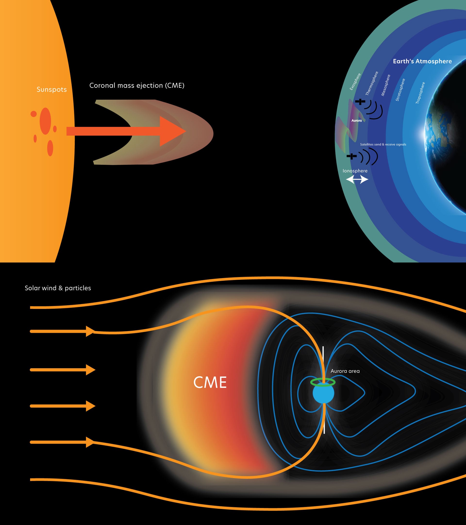
The findings carry important practical implications. During geomagnetic storms, energy released from the Sun can generate electrical currents that move through the ground and into power infrastructure. The 1989 Québec blackout demonstrated the danger when storm-driven geoelectric fields overwhelmed the Hydro-Québec power system, cutting electricity to millions of people.
Kelbert and her colleagues found that during the same storm, geoelectric field amplitudes at a site in Maine reached 22.79 volts per kilometer (36.7 volts per mile). At that intensity, the ground conducted electricity far beyond the limits most power systems are designed to withstand. Electrical grids are built to manage alternating current, not direct current.
“I believe that anything above 1 V/km is considered a threat by the power grid industry,” Kelbert said. “For anything like 20 V/km, if the geoelectric field of that amplitude was oriented along a typical 200-km power line in Maine, we’d be looking at voltages of 4,000 V, which would be driving a strong quasi-DC current across that line.”
Solar Storms Pose Growing Threat to Power Grids
A prolonged surge of direct current can overload transformers, causing overheating and potentially destroying equipment that is expensive and slow to replace. A major event larger than the 1989 blackout could leave large parts of the country without power for an extended period.
Kelbert said the USMTArray significantly improves the ability to assess these risks. In the past, researchers relied on simplified one-dimensional models to estimate how electricity moved underground. The new survey shows that underground geology across the United States is far more complicated. Geoelectric risks can vary sharply even between locations only a few miles apart, with some nearby areas showing differences as large as sites separated by hundreds of miles.
Today, information from the USMTArray feeds into a real-time hazard map operated by the National Oceanic and Atmospheric Administration (NOAA) and the United States Geological Survey (USGS). The system tracks electric fields across the country during geomagnetic storms, helping scientists and emergency officials estimate risks at specific locations with far greater detail than before.
Massive Survey Reveals Ancient Structures Beneath North America
The project began in 2006 with the goal of building a detailed image of North America’s deep geological structure. The resulting three-dimensional electrical model traces the movement of ancient landmasses that collided long ago, maps stable continental regions that have survived for billions of years, and reveals how North America formed. Unlike seismic techniques, these electrical measurements can identify features such as inactive ancient subduction zones marked by conductive materials like graphite and sulfide minerals buried deep underground.
Because the map can identify underground fluids and electrically conductive minerals, researchers say it may also help locate valuable resources, including mineral deposits and underground heat sources.
“There is still a gap between knowing the geoelectric fields in real-time and using this information to make timely operational decisions,” Kelbert said. “Prediction, not just detection, is the next frontier.”
Reference: “The United States Magnetotelluric Array and the National Impedance Map” by Anna Kelbert, Paul A. Bedrosian, Adam Schultz, Gary D. Egbert, Louise Pellerin, Jeffrey J. Love, Andrew Frassetto and Benjamin S. Murphy, 1 May 2026, Reviews of Geophysics.
DOI: 10.1029/2024RG000850
Never miss a breakthrough: Join the SciTechDaily newsletter.
Follow us on Google and Google News.
3 Comments
Shocking!
Americans have it coming, they’ll be at the bottom of the ocean where they belong.
How is that hate talk contributing anything substantive to what should be a discussion of science? Is that the best you can do? Don’t you have ANYTHING to contribute that would demonstrate that you are anything but a foreign agent ‘bot?