A new map of Mars is altering our perception of the planet’s watery past, and indicating potential landing sites for future missions.
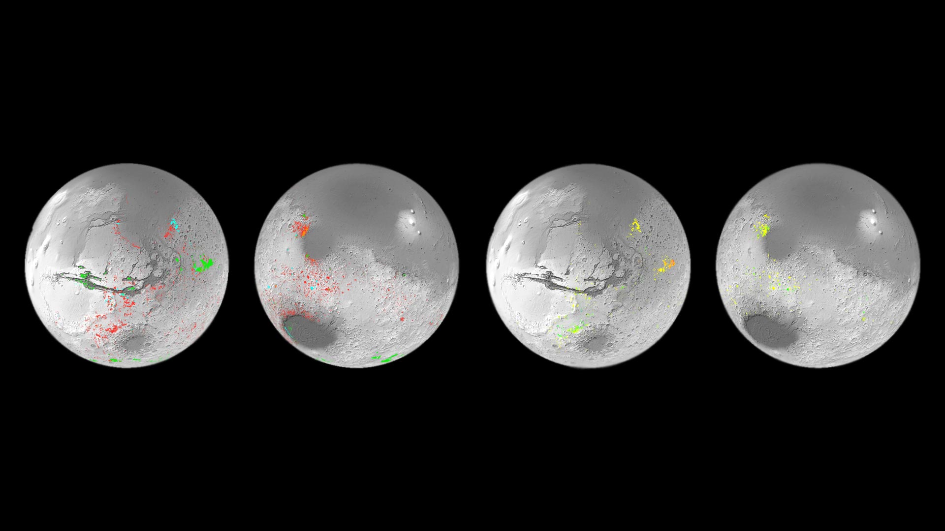
The map shows mineral deposits across the red planet. It has been painstakingly created over the last decade using data from ESA’s Mars Express Observatoire pour la Mineralogie, l’Eau, les Glaces et l’Activité (OMEGA) instrument and NASA’s Mars Reconnaissance Orbiter Compact Reconnaissance Imaging Spectrometer for Mars (CRISM) instrument.
Specifically, the map displays the locations and abundances of aqueous minerals. These come from rocks that have been chemically transformed by the action of water in the past, and have typically been converted into clays and salts.
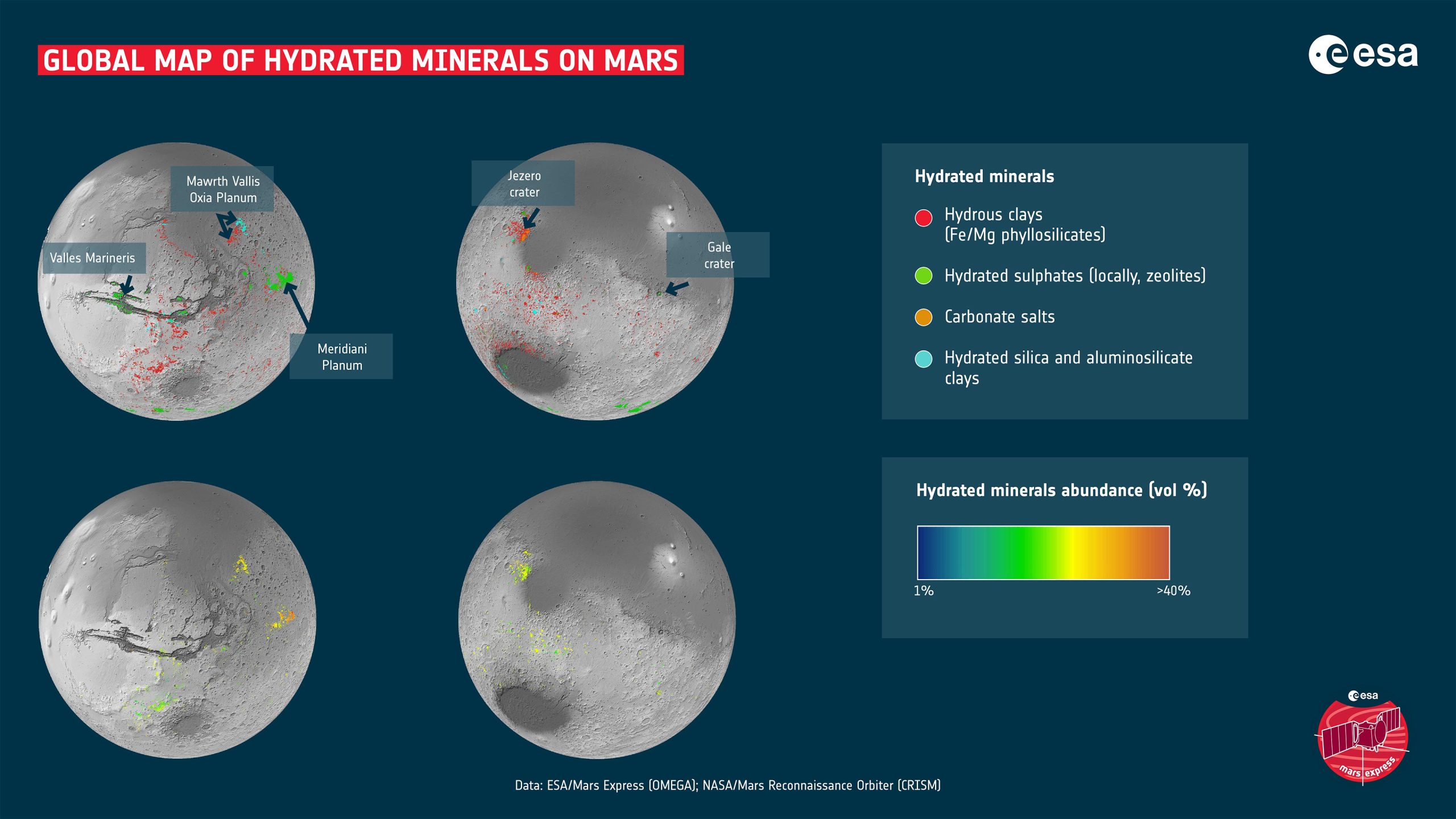
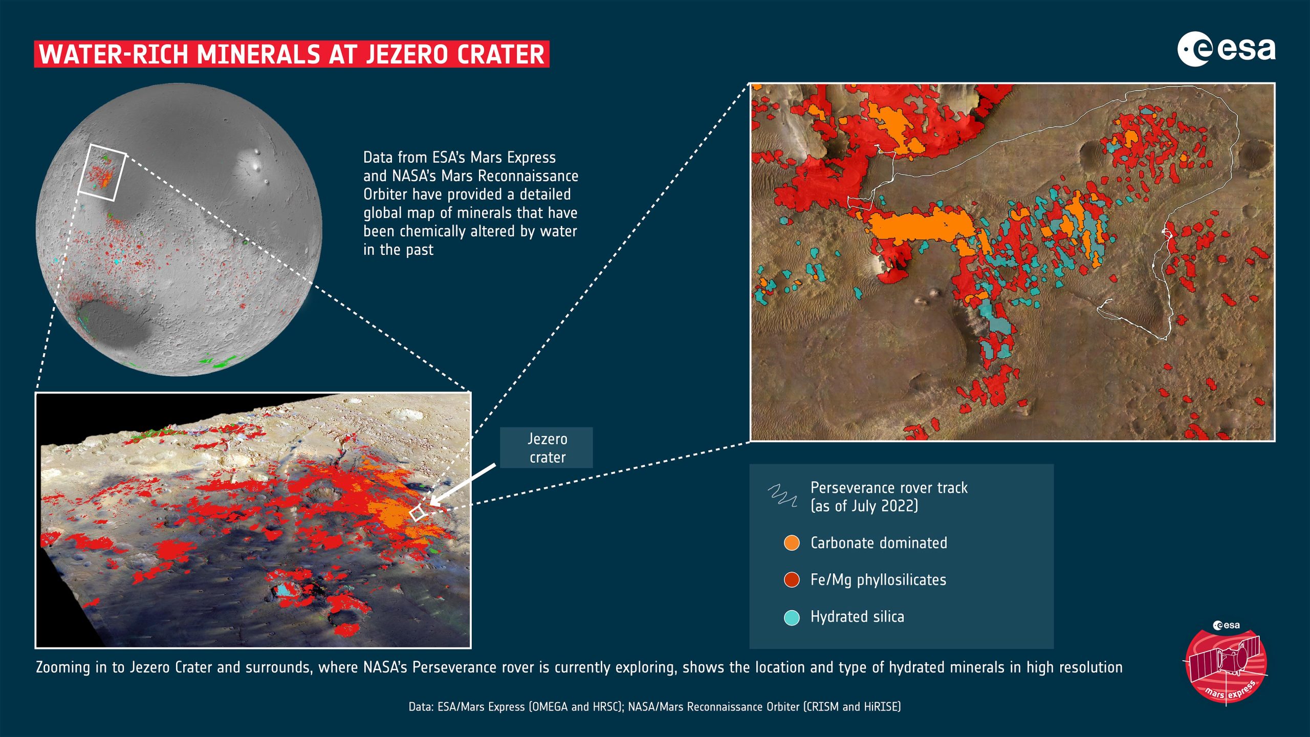
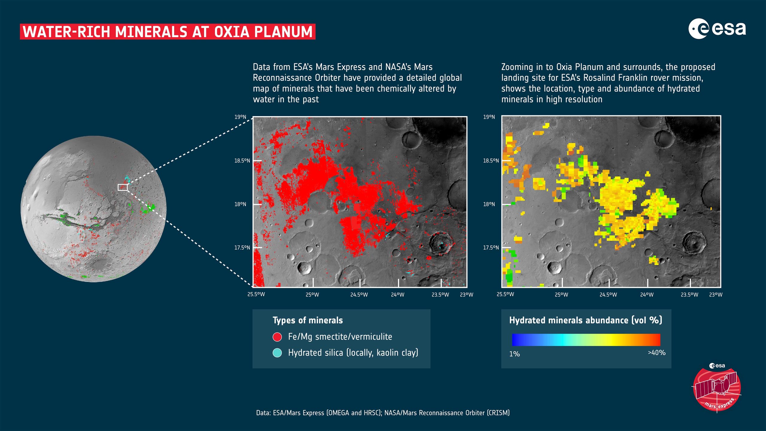
Various landing sites and areas of interest are shown on the map. Mawrth Vallis is an ancient water outflow channel that is rich in clays. Oxia Planum is another clay-rich region and has been selected as the landing site for ESA’s Rosalind Franklin rover. Meridiani Planum straddles the martian equator and was the landing spot for NASA’s Mars Exploration Rover Opportunity in 2004. Valles Marineris is one of the largest canyons in the Solar System. Gale crater and Jezero crater were the landing sites of NASA’s Curiosity and Perseverance rovers in 2012 and 2020 respectively.
The clays shown on the map include iron and magnesium phyllosilicates, zeolites, and aluminosilicate clays. The salts shown are carbonates made of carbon and oxygen. Credit: ESA/Mars Express (OMEGA) and NASA/Mars Reconnaissance Orbiter (CRISM)
Discovery of Widespread Aqueous Minerals
On Earth, clays are created when water interacts with rocks, with different conditions giving rise to different types of clays. For instance, clay minerals such as smectite and vermiculite form when relatively small amounts of water interact with the rock. Therefore, they retain mostly the same chemical elements as the original volcanic rocks. In the case of smectite and vermiculite, those elements are iron and magnesium. The rocks can be altered more when the amount of water is relatively high. Soluble elements tend to be carried away leaving behind aluminum-rich clays such as kaolin.
The big surprise for researchers is the prevalence of these minerals. Ten years ago, planetary scientists only knew of around 1000 outcrops on Mars. This made them interesting as geological oddities. However, the new map has reversed the situation, revealing hundreds of thousands of such areas in the oldest parts of the planet.
“This work has now established that when you are studying the ancient terrains in detail, not seeing these minerals is actually the oddity,” says John Carter, Institut d’Astrophysique Spatiale (IAS) and Laboratoire d’Astrophysique de Marseille (LAM), Université Paris-Saclay and Aix Marseille Université, France.
ESA’s Mars Express and NASA’s Mars Reconnaissance Orbiter have mapped water-rich rocks across Mars. The new global map is changing the way we think about the planet’s watery past, and shows where we could land future missions for further exploration. A big surprise is the prevalence of these minerals, with the map revealing hundreds of thousands of water-affected locations in the oldest parts of the planet. The new data will help answer exciting questions about Mars’ climate history, whether water was globally persistent or confined to short, intense episodes, and whether the conditions were ever suitable for life. Credit: ESA – European Space Agency
This is a paradigm shift in our understanding of the red planet’s history. It seemed plausible that water was limited in its extent and duration based on the smaller number of aqueous minerals that we previously knew were present. However, now there can be no doubt that water played a huge role in shaping the geology all around the planet.
Now, the key issue at point is whether the water was persistent or confined to shorter, more intense episodes. While not yet providing a definitive answer, the new results certainly give scientists a stronger tool for pursuing the answer.
“I think we have collectively oversimplified Mars,” says Carter. He explains that planetary scientists have tended to think that only a few types of clay minerals on Mars were created during its wet period, then as the water gradually dried up, salts were produced across the planet.
Complex Mineralogical History of Mars
This new map shows that it’s more complicated than previously thought. While many of the Martian salts probably did form later than the clays, the map shows many exceptions where there is intimate mixing of salts and clays. There are even some salts that are presumed to be older than some clays.
“The evolution from lots of water to no water is not as clear cut as we thought, the water didn’t just stop overnight. We see a huge diversity of geological contexts, so that no one process or simple timeline can explain the evolution of the mineralogy of Mars. That’s the first result of our study. The second is that if you exclude life processes on Earth, Mars exhibits a diversity of mineralogy in geological settings just as Earth does,” he says.
In other words, the closer we look, the more complex Mars’s past becomes.
The OMEGA and CRISM instruments are ideally suited to this survey. Their datasets are highly complementary, working over the same wavelength range, and sensitive to the same minerals. CRISM uniquely provides high-resolution spectral imaging of the surface (down to 15m/pixel) for highly localized patches of Mars, and makes it the most suitable for mapping small regions of interest, such as rover landing sites. For instance, the mapping shows that Jezero crater where NASA’s 2020 Perseverance rover is currently exploring, displays a rich variety of hydrated minerals.
On the other hand, OMEGA provides global coverage of Mars at higher spectral resolution and with a better signal-to-noise ratio. This makes it better suited for global and regional mapping, and discriminating between the different alteration minerals.
Implications for Future Mars Missions
The results are presented in a pair of scientific papers, written by Carter, Lucie Riu, and colleagues. Lucie was at the Institute of Space and Astronautical Science (ISAS), Japanese Aerospace eXploration Agency (JAXA), Sagamihara, Japan, when part of the work was performed but is now an ESA Research Fellow at ESA’s European Space Astronomy Center (ESAC) in Madrid.
With the basic detections in hand, Lucie decided to take the next step and quantify the amounts of the minerals that were present. “If we know where, and in which percentage each mineral is present, it gives us a better idea of how those minerals could have been formed,” she says.
Due to two factors, this work also provides mission planners with several excellent candidates for potential future landing sites. First off, water molecules are still present in the aqueous minerals. Together with known locations of buried water-ice, this offers potential areas for water extraction for In-situ Resource Utilization, which is essential to the building of human bases on Mars. Salts and clays are often used construction materials on Earth.
Secondly, even before humans go to Mars, the aqueous minerals provide fantastic locations in which to perform science. As part of this mineral mapping campaign, the clay-rich site of Oxia Planum was discovered. These ancient clays include the iron and magnesium-rich minerals of smectite and vermiculite. Not only can they help unlock the planet’s past climate, but they are perfect sites to investigate whether there was once life on Mars. As such, Oxia Planum was proposed and finally selected as the landing site for ESA’s Rosalind Franklin rover.
“This is what I am interested in, and I think this kind of mapping work will help open up those studies going forward,” says Lucie.
As ever when dealing with Mars, the more we learn about the planet, the more fascinating it becomes.
References:
“A Mars Orbital Catalog of Aqueous Alteration Signatures (MOCAAS)” by John Carter, Lucie Riu, François Poulet, Jean-Pierre Bibring, Yves Langevin and Brigitte Gondet, 20 August 2022, Icarus.
DOI: 10.1016/j.icarus.2022.115164
“The M3 project: 3 – Global abundance distribution of hydrated silicates at Mars” by Lucie Riu, John Carter and François Poulet, 25 November 2021, Icarus.
DOI: 10.1016/j.icarus.2021.114809
Never miss a breakthrough: Join the SciTechDaily newsletter.
Follow us on Google and Google News.
1 Comment
This is groovy, but we need to go to the moon first.