
Puerto Rico went from no drought to widespread extreme drought in just months as rainfall collapsed and water shortages spread.
Puerto Rico usually enters its wet season in May. In 2026, however, the expected rains largely failed to arrive through late August, leaving much of the U.S. territory in drought. The prolonged dry spell has contributed to water shortages and rationing in some communities, prompting Puerto Rico’s governor to declare a state of emergency in late July. In late August, the U.S. government also approved a drought disaster declaration covering more than two dozen cities and towns.
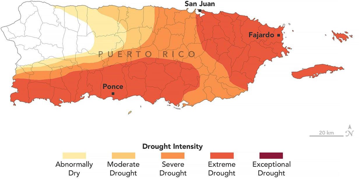
Mapping Puerto Rico’s Expanding Drought
A map dated August 25, 2026, shows the extent and intensity of drought across Puerto Rico. It was created by the U.S. Drought Monitor, a collaborative effort involving the National Drought Mitigation Center at the University of Nebraska-Lincoln, the U.S. Department of Agriculture (USDA), the National Oceanic and Atmospheric Administration, and NASA.
NASA has supported the U.S. Drought Monitor for years by contributing Earth observations and scientific expertise. That role expanded in 2026 when two NASA scientists joined the small group responsible for producing the project’s weekly drought assessments.
Satellites and Ground Data Reveal the Drying
David Mocko, a senior research scientist in the Hydrological Sciences Laboratory at NASA’s Goddard Space Flight Center, said signs of the hot and dry conditions were visible across several types of satellite data and ground observations used by the U.S. Drought Monitor.
For recent Puerto Rico assessments, particularly important measurements included satellite estimates of soil moisture, along with weather data and observations of streamflow and well conditions, Mocko said.
Mocko authored the U.S. Drought Monitor update for August 18, 2026. He and Jonathan Case of NASA’s Marshall Space Flight Center are the first NASA scientists to produce the weekly maps.
Extreme Drought Covers 44 Percent of Puerto Rico
By August 25, 2026, about three-quarters of Puerto Rico was experiencing at least moderate drought, according to the U.S. Drought Monitor assessment. Areas classified as extreme drought (dark orange), concentrated in eastern and southwestern parts of the main island, had expanded during the previous week and covered 44 percent of the territory.

The speed of the change was striking. Just three months earlier, none of Puerto Rico was in drought, and less than 20 percent of the territory was considered abnormally dry.
Late winter and early spring had actually brought wetter-than-normal conditions across the U.S. Caribbean, according to the National Integrated Drought Information System (NIDIS). Conditions then shifted sharply toward dryness.
Rainfall Fell Far Below Normal
Between mid-May and mid-July, most of Puerto Rico received less than 60 percent of its normal precipitation, according to NIDIS. Conditions were even more severe in the south and southwest, where rainfall totals fell below 20 percent of normal. That translated to a rainfall deficit of 3 to 6 inches (76 to 152 millimeters).
Unusually high temperatures made the drying worse. San Juan, for example, experienced one of its warmest Julys on record.
Rivers also showed the effects. Streamflow dropped to record-low levels in waterways including the Rio Fajardo in northeastern Puerto Rico.
Water Shortages Hit Residents and Farms
The strain on water supplies has affected residents, farmers, and ranchers across Puerto Rico. Water rationing has been in effect in several municipalities since early August, according to news reports.
Observers have also pointed to infrastructure issues as a factor making shortages more difficult to manage.
For farmers, dry soils have disrupted the growth of fruit trees, cacao, bananas, coffee, and other crops, contributing to agricultural losses. Ranchers, meanwhile, are dealing with shrinking reserves of hay for livestock.
Drought Maps Help Direct Emergency Aid
The U.S. Drought Monitor has published weekly drought maps since 1999. The assessments help federal, state, local, and tribal officials determine how to respond as drought conditions develop and intensify.
The USDA, for example, uses the maps in a “fast track” process for disaster designations. Those declarations can help unlock emergency resources for communities, farmers, and others affected by severe drought.
NASA Earth Observatory image by Michala Garrison, using data from the U.S. Drought Monitor at the University of Nebraska-Lincoln.
Never miss a breakthrough: Join the SciTechDaily newsletter.
Follow us on Google and Google News.