Close Menu
    Facebook X (Twitter) Instagram
    SciTechDaily
    • Biology
    • Chemistry
    • Earth
    • Health
    • Physics
    • Science
    • Space
    • Technology
    Facebook X (Twitter) Pinterest YouTube RSS
    SciTechDaily
    Home»Earth»A Vivid Space Perspective: Nueva Vizcaya, Philippines
    Earth

    A Vivid Space Perspective: Nueva Vizcaya, Philippines

    By European Space Agency (ESA)December 22, 2023No Comments3 Mins Read
    Facebook Twitter Pinterest Telegram LinkedIn WhatsApp Email Reddit
    Share
    Facebook Twitter LinkedIn Pinterest Telegram Email Reddit
    Nueva Vizcaya Philippines From Space
    This Copernicus Sentinel-2 image showcases Nueva Vizcaya Province in the Philippines, highlighting its agricultural landscape and urban areas through a false-color composite. In the image, different seasons are represented with varying colors, revealing intricate details about crop growth stages, waterlogged fields for rice production, and urbanization. Credit: Contains modified Copernicus Sentinel data (2022-23), processed by ESA, CC BY-SA 3.0 IGO

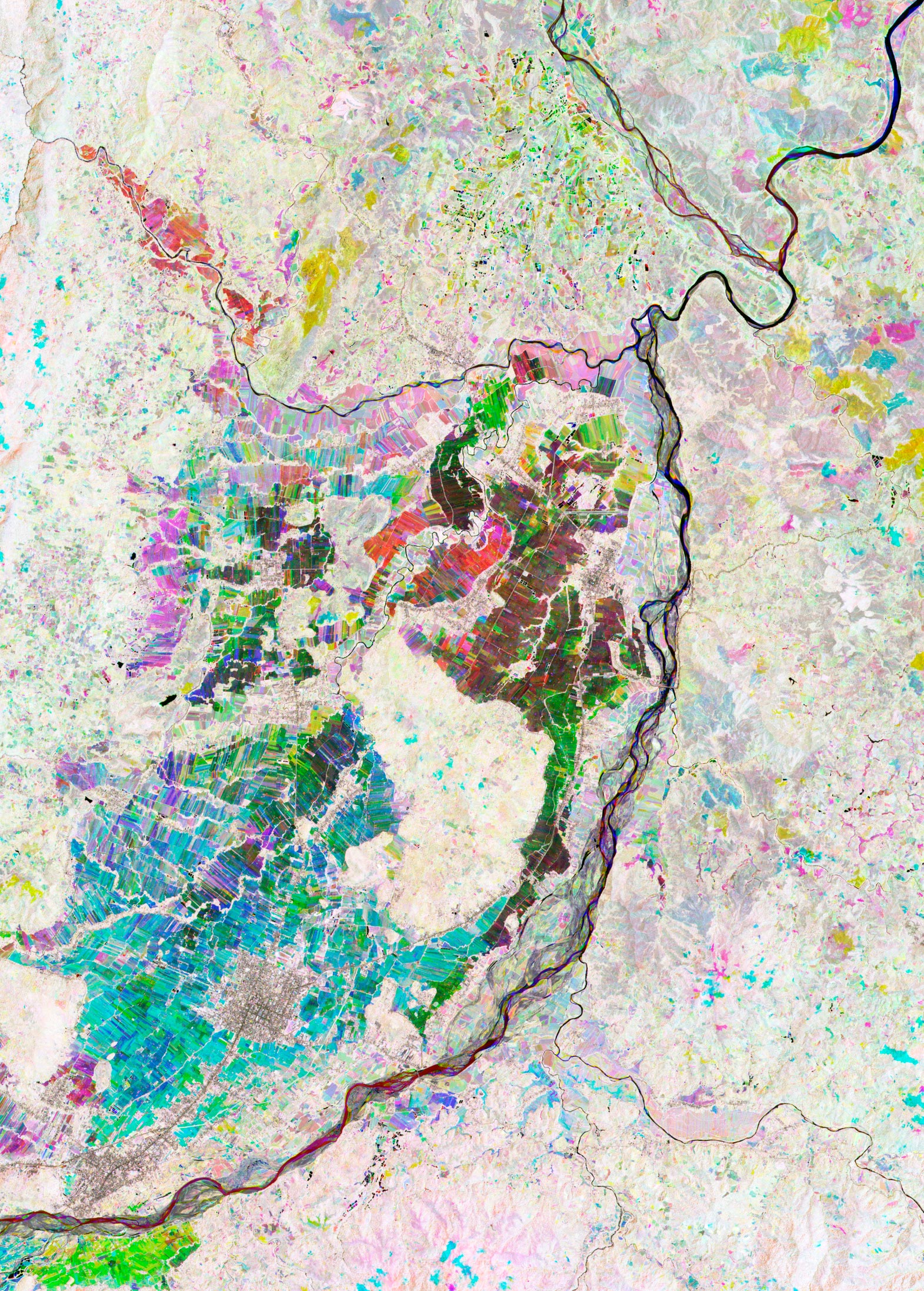
    The heart of the Nueva Vizcaya Province on Luzon, the largest and most populated island of the Philippines, shows up brightly in this Copernicus Sentinel-2 false-color satellite image.

    The colors in the image are due to it being a multitemporal composite, made up of three Copernicus Sentinel-2 images acquired with the mission’s near-infrared channel over a period of 10 months. Different colors have been assigned to each acquisition: red to an acquisition in May 2022 during the hot dry season, green to one in September 2022 during the wet season, and blue to one in March 2023 in the cool dry season. 

    This combination highlights different features, such as crop types, and changes that occurred between acquisitions which show the different growth stages.

    A patchwork of colorful agricultural fields stand out in the center to bottom left of the image. Areas in shades of red and green mean that the plant growth took place in May and September respectively. Fields visible in shades of blue, which dominate the image, show that the plant growth occurred mainly in March during the cool dry season.

    Most fields are left waterlogged all year round, probably for intensive rice production, with canals between them. Bright white areas, as in the middle of the fields, indicate zones covered with dense vegetation.

    Straight lines and areas in grey depict roads and urban areas. These include Solano, the largest town in Nueva Vizcaya, visible in the bottom left surrounded by blue fields, and further south is Bayombong, the capital of the province.

    The dark winding lines depict rivers, with the biggest, Magat River, flowing in a north-easterly direction across the image. Taking a closer look, different colors can be spotted along the course of the rivers. This is most likely due to changes in water volume and in the river paths at different times of the year.

    With its 13 spectral channels, Copernicus Sentinel-2 is designed to provide data that can be used to map and monitor croplands and the mission’s frequent revisits over the same area and high spatial resolution allow changes in inland water bodies to be closely monitored.

    In January 2023, ESA and the European Commission signed an agreement to build a Copernicus mirror site in the Philippines – the first of its kind in southeast Asia. This new initiative will enhance the response capability and resilience of the Philippines to natural and human-made disasters through the strategic use of space data.

    Never miss a breakthrough: Join the SciTechDaily newsletter.
    Follow us on Google and Google News.

    European Space Agency Geography
    Share. Facebook Twitter Pinterest LinkedIn Email Reddit

    Related Articles

    Breathtaking View of Andros, Bahamas From Space [Video]

    Stunning Views of Houston Texas From Copernicus Sentinel-1 Satellite

    Earth From Space: Bolivian Highland Heart [Video]

    Flevoland, Netherlands From Space: One of the Largest Land Reclamation Projects in the World

    Earth From Space: Lake George, Uganda – A Center for Biological Diversity [Video]

    Deforestation in Bolivia Spied From Space Satellite

    Earth From Space: Japanese Archipelago [Video]

    Earth From Space: Faroe Islands [Video]

    Earth From Space: Tromsø, Norway [Video]

    Leave A Reply Cancel Reply

    • Facebook
    • Twitter
    • Pinterest
    • YouTube

    Don't Miss a Discovery

    Subscribe for the Latest in Science & Tech!

    Trending News

    Massive Study Warns Marijuana Use in Teens Is Linked to Serious Mental Illness

    Scientists Discover a Completely Unexpected Way T Cells Kill Cancer

    Scientists Just Found the Solar System’s Original “Planet Factory”

    Study Warns Widely Used Food Preservatives Linked to High Blood Pressure and Heart Disease

    New Treatment Could Reverse Osteoarthritis Within Weeks

    Physicists Have Measured “Negative Time” in Bizarre Quantum Experiment

    The Deadly Tapeworm Spreading Across America Has Reached the Pacific Northwest

    Could Low Vitamin D Be Making Your Pain Worse?

    Follow SciTechDaily
    • Facebook
    • Twitter
    • YouTube
    • Pinterest
    • Newsletter
    • RSS
    SciTech News
    • Biology News
    • Chemistry News
    • Earth News
    • Health News
    • Physics News
    • Science News
    • Space News
    • Technology News
    Recent Posts
    • Scientists Discover Two Strange Dead Stars That Defy Astronomical Expectations
    • Scientists Find a Smarter Way To Measure the Universe Using Exploding Stars
    • Earth May Be Seeding Venus With Life, According to New Research
    • Streetlights Are Trapping Thousands of Isopods in Mysterious “Death Spirals”
    • Scientists Have Discovered These Deadly Parasites Are Secretly Swapping DNA
    Copyright © 1998 - 2026 SciTechDaily. All Rights Reserved.
    • Science News
    • About
    • Contact
    • Editorial Board
    • Privacy Policy
    • Terms of Use

    Type above and press Enter to search. Press Esc to cancel.