December 15 – 16, 2021
Hurricane-force winds, dust storms, tornadoes, wildfires, snow squalls, heavy rain, and record-breaking heat accompanied an unusual December storm system.
An anomalous and historic December derecho—a windstorm associated with an unusually strong and fast-moving line of thunderstorms—swept from the U.S. Southwest to the Upper Midwest on December 15, 2021. High-wind warnings were issued from the Central and Southern High Plains to the Great Lakes, including storm warnings over the Great Lakes.
The storm brought hurricane-force winds, dust storms, tornadoes, wildfires, snow squalls, and heavy rain across the middle of the country. Hundreds of thousands of homes and businesses lost electric power, and roughly 100 million Americans were under some type of weather warning that day.
The animation above shows the evolution of the storm front and wind field between 6 p.m. Central Time on December 14 (midnight UTC, December 15) and 3 a.m. CT (9:00 UTC) on December 16. The strongest winds appear bright yellow to white; more moderate winds (still gale-force) are shades of orange and bright purple. (35 meters per second equals roughly 80 miles per hour.) Atmospheric data were run through the Goddard Earth Observing System Model-5 (GEOS-5), a data assimilation model that scientists at NASA use to analyze global weather phenomena. The GEOS model ingests wind data from more than 30 sources, including ships, buoys, radiosondes, dropsondes, aircraft, and satellites. The model output is spaced out on a 0.25 to 0.3 degree grid, so it does not necessarily capture peak gusts and extremes as measured by individual instruments on the surface.
The natural-color image below was acquired around 2 p.m. CT (20:00 UTC) on December 15 by the Visible Infrared Imaging Radiometer Suite (VIIRS) on the NOAA-20 spacecraft.
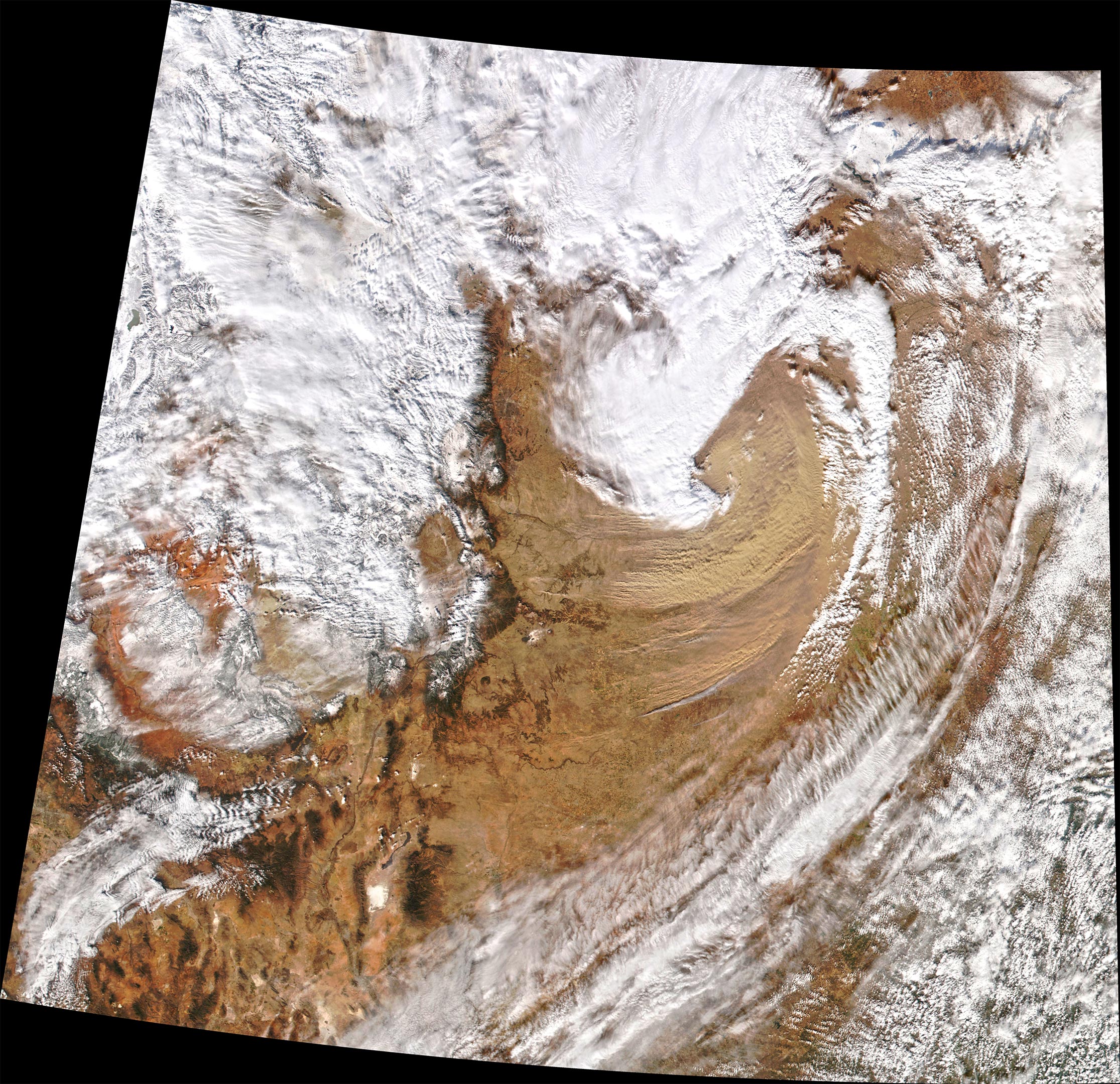
The derecho was spawned by the interaction of a deep-low pressure system over the Northern High Plains and a high-pressure system to the west. This created a tight pressure gradient over the Rocky Mountains that generated fierce winds. The storm generated at least 55 hurricane-force gusts (those exceeding 75 miles per hour), breaking the previous one-day record (since tracking began in 2004). All previous records were set during the summer months.
In Colorado, wind gusts exceeded 100 miles (160 kilometers) per hour and dust storms swirled in the southeastern part of the state and in western Kansas. Snow and rain showers, along with at least 20 tornadoes, were reported along the squall line.
Meanwhile, ahead of the front, parts of the Southern Plains into the Upper Midwest saw record-breaking warm temperatures. In Wisconsin and Iowa, temperatures reached above 70 degrees Fahrenheit (21° Celsius). The heat and the high winds also prompted extreme fire weather warnings for parts of the Central and Southern Plains, as wildfires broke out in Kansas, Texas, and Oklahoma.
NASA Earth Observatory images by Joshua Stevens, using VIIRS data from NASA EOSDIS LANCE, GIBS/Worldview, and the Joint Polar Satellite System (JPSS), and GEOS-5 data from the Global Modeling and Assimilation Office at NASA GSFC.
Never miss a breakthrough: Join the SciTechDaily newsletter.
Follow us on Google and Google News.
2 Comments
This is absolute bull sh*t spin. Was here for real derecho in 2020
“record-breaking heat”
I think that an objective report would have said, “record-breaking warmth.” Yes, it is spin!